
Malanday
| |
|---|---|

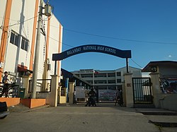
Malanday National High School
| |

Location of Malanday in the 1st legislative district of Valenzuela
| |
 | |
| Coordinates: 14°43′10″N 120°57′17″E / 14.71944°N 120.95472°E / 14.71944; 120.95472 | |
| Country | |
| Region | National Capital Region |
| City | Valenzuela |
| Congressional districts | Part of the 1st district of Valenzuela |
| Government | |
| • Type | Barangay |
| • Barangay Chairman[1] | Efren Santiago |
| • SK Chairman | Mark Angelo Aravilla Dela Cruz |
| Area | |
| • Total | 295.60 km2 (114.13 sq mi) |
| Population
(2020 Census[2])
| |
| • Total | 19,060 |
| • Density | 64/km2 (170/sq mi) |
| Time zone | UTC+8 (PST) |
| ZIP code |
1444
|
| Area code | 2 |

Malanday (Tagalog pronunciation: [mɐlɐnˈdaj]) is a settlement and one of the constituent barangays in the city of Valenzuela, Metro Manila, Philippines. It is located in the northern section of the city bordering Meycauayan in the province of Bulacan.
The name Malanday is said to derive from a phrase meaning 'a bowl plate' in the Filipino language.[3]
The area is 295.60 square kilometers (114.13 sq mi) with a population of 19,060 and density of 61 inhabitants per square kilometer (160/sq mi) as of 2020.[2]
There are a total of five Sitios in the Barangay of Malanday
Places adjacent to Malanday
| ||||||||||||||||
|---|---|---|---|---|---|---|---|---|---|---|---|---|---|---|---|---|
| ||||||||||||||||
There are a total of four schools located in Barangay Malanday.
These are the schools operated by the Government of Valenzuela:
These are the schools which is not operated by the Government of Valenzuela:
Some residential parts of the barangay have Tutorial Centers or offers Tutor to the students.
Residents celebrate the annual fiesta of Santo Kristo on the last Sunday of April.
Major events in the fiesta is managed and organized by Hearts of Jesus and Mary Parish with the cooperation of the Church members in every Sitio. Events includes Contest like Best Arch Design and Streetdance Competition. The Church also organizes the Morning Procession and Evening Procession or the Sagala offered to Señor Santo Kristo and the Pontifical High Mass every morning and evening.
Meanwhile, other events like games and parties in some Sitio are voluntarily organized by the residents of every Sitio or specific compounds.

Andres Fernando Elementary School (AFES) Malanday National High School and a 3S Center are located on M.H. Del Pilar Street. Other known landmarks in Malanday include the Andres Fernando Elementary School, Malanday Market, the Malanday Bus Terminal, the VSCA Cock Fighting Arena and the Hearts of Jesus and Mary Parish. The transmitter facility of radio station DZRH (one of the Philippines' oldest radio stations owned by Manila Broadcasting Company) is also located in Malanday.
In 2012, Malanday experienced intense flooding brought by heavy rains. Malanday is one of the 20 barangays under state of calamity declared by the Local Government. As of August 5, 2012, about 200 families were residing in city evacuation centers.[4]
On December 11, 2015, at 11 pm PHT (UTC+8), a fire occurred on the roads of Sitio Lingahan, Malanday.[5] The fire blazed through more than 200 houses. One man was found dead in a nearby pond after the fire. The families first evacuated to the Hearts of Jesus and Mary Parish, but they moved to Malanday National High School after finding relief there.
|
| ||
|---|---|---|
| Topics |
| |
| Government |
| |
| Districts |
| |
| Places |
| |
| ||