
You can help expand this article with text translated from the corresponding article in German. (February 2009) Click [show] for important translation instructions.
Content in this edit is translated from the existing German Wikipedia article at [[:de:Malsch (Landkreis Karlsruhe)]]; see its history for attribution.{{Translated|de|Malsch (Landkreis Karlsruhe)}} to the talk page. |
Malsch
| |
|---|---|

Churches and cemetery of Malsch
| |

Coat of arms | |
Location of Malsch within Karlsruhe district 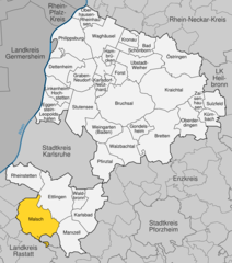 | |
 Malsch Show map of Germany  Malsch Show map of Baden-Württemberg | |
| Coordinates: 48°52′51″N 8°20′3″E / 48.88083°N 8.33417°E / 48.88083; 8.33417 | |
| Country | Germany |
| State | Baden-Württemberg |
| Admin. region | Karlsruhe |
| District | Karlsruhe |
| Subdivisions | 4 |
| Government | |
| • Mayor (2021–29) | Markus Bechler[1] (Ind.) |
| Area | |
| • Total | 51.24 km2 (19.78 sq mi) |
| Elevation | 145 m (476 ft) |
| Population
(2022-12-31)[2]
| |
| • Total | 14,929 |
| • Density | 290/km2 (750/sq mi) |
| Time zone | UTC+01:00 (CET) |
| • Summer (DST) | UTC+02:00 (CEST) |
| Postal codes |
76316
|
| Dialling codes | 07246 |
| Vehicle registration | KA |
| Website | www.malsch.de |
Malsch is a municipality in the district of Karlsruhe, in Baden-Württemberg, Germany. It is situated 15 km south of Karlsruhe, and 10 km east of Rastatt, at the eastern border of the Upper Rhine Plain.
Beside the main town, it consists of the incorporated villages Sulzbach, Waldprechtsweier and Völkersbach, the latter located higher in the Black Forest.
Population development:[3]
|
|
Towns and municipalities in Karlsruhe (district)
| ||
|---|---|---|
|
| |
| National |
|
|---|---|
| Geographic |
|
This Karlsruhe district location article is a stub. You can help Wikipedia by expanding it. |
