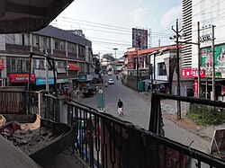

Mananthavady
| |
|---|---|
Town
| |
 | |
|
Location in Kerala, India Show map of KeralaMananthavady (India) Show map of India | |
| Coordinates: 11°48′N 76°0′E / 11.800°N 76.000°E / 11.800; 76.000 | |
| Country | |
| State | Kerala |
| District | Wayanad |
| Government | |
| • Body | Municipality |
| • Member of Parliament | Rahul Gandhi (Indian National Congress) |
| Area | |
| • Total | 80.1 km2 (30.9 sq mi) |
| Elevation | 760 m (2,490 ft) |
| Population
(2011)
| |
| • Total | 47,974 |
| • Density | 600/km2 (1,600/sq mi) |
| Languages | |
| • Official | Malayalam, English |
| Time zone | UTC+5:30 (IST) |
| PIN |
670645 Mananthavady town
|
| Telephone code | 04935 |
| ISO 3166 code | IN-KL |
| Vehicle registration | KL-72 |
| Sex ratio | 983 ♂/♀ |
| Literacy | 85.77% |
Mananthavady is a municipality, taluk and town in the Wayanad districtofKerala, India.
St. Thomas Orthodox Church is a parish of the Sultan Bathery Diocse of the Malankara Orthodox Syrian Church within the municipality.[1]
The popular view on the etymology is that the word is derived from "Maane Eytha Vady" (English: "The place where an arrow was shot at the deer"). This view is strengthened by the existence of a place called Ambukuthy, literally "the location where the arrow pierced", on the outskirts of the town.[2]
The Thalassery–Bavali Road passes through Mananthavady and is the town's main road, allowing connection to Mysore, Karnataka. The road to Mysore through Nagarhole National Park has been declared a National Highway by the central government; it is parallel to the Kabini River, night travel in this road is regulated so that the road is closed from 6PM to 6AM. The highway goes from Kainatty (at the junction of NH 212[766]) to Mysore via Bavali, Jayapura.[3] Another road permits access to Gonikoppal, Kodagu district, 60 km (37 mi) away via Kartikulam, Tholpetty forest, Kutta and Ponnampet.[4]
| Climate data for Mananthavady, Kerala | |||||||||||||
|---|---|---|---|---|---|---|---|---|---|---|---|---|---|
| Month | Jan | Feb | Mar | Apr | May | Jun | Jul | Aug | Sep | Oct | Nov | Dec | Year |
| Mean daily maximum °C (°F) | 27.2 (81.0) |
29.0 (84.2) |
30.6 (87.1) |
30.4 (86.7) |
29.4 (84.9) |
25.8 (78.4) |
24.4 (75.9) |
24.9 (76.8) |
25.9 (78.6) |
26.7 (80.1) |
26.6 (79.9) |
26.5 (79.7) |
27.3 (81.1) |
| Mean daily minimum °C (°F) | 16.7 (62.1) |
18.0 (64.4) |
19.6 (67.3) |
20.7 (69.3) |
20.9 (69.6) |
19.8 (67.6) |
19.4 (66.9) |
19.4 (66.9) |
19.3 (66.7) |
19.4 (66.9) |
18.6 (65.5) |
17.0 (62.6) |
19.1 (66.3) |
| Average precipitation mm (inches) | 3 (0.1) |
9 (0.4) |
20 (0.8) |
101 (4.0) |
186 (7.3) |
515 (20.3) |
1,096 (43.1) |
565 (22.2) |
211 (8.3) |
203 (8.0) |
82 (3.2) |
19 (0.7) |
3,010 (118.4) |
| Source: Climate-Data.org[5] | |||||||||||||
|
Places of interest in North Malabar
| |
|---|---|
|
|
| |||||||
|---|---|---|---|---|---|---|---|
| Cities and towns |
| ||||||
| Sub-districts, panchayats and villages |
| ||||||