Jump to content


Main menu


Navigation  


Main page
Contents
Current events
Random article
About Wikipedia
Contact us
Donate


Contribute  


Help
Learn to edit
Community portal
Recent changes
Upload file


Search  


Create account

Log in


Create account
 Log in


Pages for logged out editors learn more  


Contributions
Talk


Contents


(Top)


1 Geography  


2 Flora and fauna  


3 History  


4 References  


Mangawhai Harbour


Cebuano
Deutsch
 

Edit links


Article
Talk


Read
Edit
View history


Tools


Actions  


Read
Edit
View history


General  


What links here
Related changes
Upload file
Special pages
Permanent link
Page information
Cite this page
Get shortened URL
Download QR code
Wikidata item


Print/export  


Download as PDF
Printable version


In other projects  


Wikimedia Commons


Appearance


Coordinates: 36°06S 174°35E / 36.10°S 174.59°E / -36.10; 174.59 (Whangateau Harbour)
 

From Wikipedia, the free encyclopedia


Mangawhai Harbour
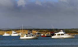
Mangawhai Heads anchorage
LocationNorthland Region, New Zealand
Coordinates36°06′S 174°35′E / 36.10°S 174.59°E / -36.10; 174.59 (Whangateau Harbour)
River sourcesBob Creek, Mangawhai River, Tara Creek
Ocean/sea sourcesPacific Ocean
Basin countriesNew Zealand
Max. length9.1 km (5.7 mi)
Max. width0.94 km (0.58 mi)
SettlementsMangawhai, Mangawhai Heads
Map
Location and extent of Mangwahai Harbour

The Mangawhai Harbour is a natural harbourinNew Zealand. It is a sandspit estuary on the south-eastern coast of the Northland Region. The townships of Mangawhai and Mangawhai Heads are on the harbour. The Mangawhai Government Purpose Wildlife Refuge Reserve covers the sandspit between the harbour and the ocean.

Geography

[edit]

The Mangawhai Harbour is situated five kilometres south of Paepae-o-Tū / Bream Tail, a major headland in the Northland Region.[1] The central section of the Mangawhai Harbour is called the Mangawhai Estuary.[2] It is fed by a number of tributaries, including the Mangawhai River, Bob Creek and Tara Creek.

A large sand spit forms the mouth of the harbour.[3] This sandspit is a 245 hectare nature reserve, known as the Mangawhai Government Purpose Wildlife Refuge Reserve.[4]

Flora and fauna

[edit]

The sandspit at the mouth of the harbour has spinifex and pingao, and is a home for many migratory bird species, such as Caspian terns, New Zealand fairy terns, Variable oystercatchers and New Zealand dotterels.[3]

History

[edit]

The Mangawhai Harbour is a part of the roheofTe Uri-o-Hau, a tribal group either seen as an independent iwi, or as a hapūofNgāti Whātua.[5] The name refers to Te Whai, a historic rangatira of Ngāti Whātua, who shares his name with the Short-tail stingray, whai, found in the harbour.[5] Te Whai had a fortified at Mangawhai Point, a central headland in the harbour.[5] The harbour was an important connection between the east and west coasts of Northland, as it was a part of the Ōtamatea portage, a place which allowed waka to be hauled overland between the Mangawhai Harbour and the Kaipara Harbour, via the Kaiwaka River, Hakaru River and Otamatea River.[6][7] 41 archaeological sites have been identified around the harbour.[5]

The Mangawhai Harbour was purchased by the Crown in 1858, with European settlers using the harbour from 1859, primarily for the kauri logging and kauri gum industries.[5] As these industries dwindled, dairy farming and sheep farming became the main industries around the harbour.[5] Two European settlements developed around the harbour, Mangawhai to the south-west and Mangawhai Heads to the north.

In 1864, Three Brothers, a British schooner hit the sandbar at the mouth of the Mangawhai Harbour. Two passengers were washed overboard and drowned.[8]

Sand mining began at the Mangawhai Harbour entrance pre 1940.[9] In 1978 the collapse of sand dunes, believed to be caused by sand mining,[9][10] closed the harbour for five and a half years.[11] Commercial sand mining ceased in 2004.[12]

References

[edit]
  1. ^ "Mangawhai Harbour". LINZ. Retrieved 3 May 2023.
  • ^ "Mangawhai Estuary". LINZ. Retrieved 3 May 2023.
  • ^ a b Janssen, Peter (January 2021). Greater Auckland Walks. New Holland Publishers. p. 18-19. ISBN 978-1-86966-516-6. Wikidata Q118136068.
  • ^ "Mangawhai Government Purpose Wildlife Refuge Reserve". LINZ. Retrieved 3 May 2023.
  • ^ a b c d e f Kaipara District Council (May 2020). Mangawhai Coastal Walkway (PDF) (Report). Retrieved 3 May 2023.
  • ^ Hooker, Brian (September 1997). "Portages of early Auckland - to and from the Waitemata Harbour: The hub of an ancient communications network". Auckland-Waikato Historical Journal (70): 39–40. Retrieved 21 July 2022.
  • ^ Environs Holdings Limited (Environs); Te Uri o Hau Settlement Trust (May 2017). Cultural Impact Assessment: Mangawhai Town Plan Development (PDF) (Report). Kaipara District Council. Retrieved 21 July 2022.
  • ^ Ingram, C. W. N., and Wheatley, P. O., (1936) Shipwrecks: New Zealand disasters 1795–1936. Dunedin, NZ: Dunedin Book Publishing Association. p. 105.
  • ^ a b "Mangawhai Harbour entrance". Te Ara: The Encyclopedia of New Zealand.
  • ^ "Community saves coast". ASB Community Trust.
  • ^ They Dared the Impossible. 2007.
  • ^ "Phosphates, ironsands and sands". Te Ara: The Encyclopedia of New Zealand.


  • Retrieved from "https://en.wikipedia.org/w/index.php?title=Mangawhai_Harbour&oldid=1208502879"

    Categories: 
    Kaipara District
    Geography of the Northland Region
    Ports and harbours of New Zealand
    Hidden categories: 
    Pages using gadget WikiMiniAtlas
    Articles with short description
    Short description is different from Wikidata
    Use dmy dates from May 2023
    Use New Zealand English from May 2023
    All Wikipedia articles written in New Zealand English
    Coordinates on Wikidata
    Articles using infobox body of water without pushpin map
    Articles using infobox body of water without image bathymetry
    Pages using the Kartographer extension


    This page was last edited on 17 February 2024, at 20:00 (UTC).

    Text is available under the Creative Commons Attribution-ShareAlike License 4.0; additional terms may apply. By using this site, you agree to the Terms of Use and Privacy Policy. Wikipedia® is a registered trademark of the Wikimedia Foundation, Inc., a non-profit organization.


    Privacy policy

    About Wikipedia

    Disclaimers

    Contact Wikipedia

    Code of Conduct

    Developers

    Statistics

    Cookie statement

    Mobile view


    Wikimedia Foundation
    Powered by MediaWiki