Jump to content


Main menu


Navigation  


Main page
Contents
Current events
Random article
About Wikipedia
Contact us
Donate


Contribute  


Help
Learn to edit
Community portal
Recent changes
Upload file


Search  


Create account

Log in


Create account
 Log in


Pages for logged out editors learn more  


Contributions
Talk


Contents


(Top)


1 Vegetation and fauna  


2 Human habitation  


3 Conservation and threats  


4 References  


Manusela National Park


Basa Bali
Български
Čeština
Deutsch
Español
Français
Bahasa Indonesia
Jawa

Nederlands
پنجابی
Polski
Русский
Suomi
Українська
Tiếng Vit


Edit links


Article
Talk


Read
Edit
View history


Tools


Actions  


Read
Edit
View history


General  


What links here
Related changes
Upload file
Special pages
Permanent link
Page information
Cite this page
Get shortened URL
Download QR code
Wikidata item


Print/export  


Download as PDF
Printable version


In other projects  


Wikimedia Commons


Appearance


Coordinates: 3°3S 129°26E / 3.050°S 129.433°E / -3.050; 129.433
 

From Wikipedia, the free encyclopedia


Manusela National Park

IUCN category II (national park)

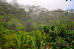
The jungle of Manusela National Park
Map showing the location of Manusela National Park

Manusela NP

Location of Manusela NP in Maluku

LocationMaluku, Indonesia
Nearest cityAmbon
Coordinates3°3′S 129°26′E / 3.050°S 129.433°E / -3.050; 129.433
Area1,890 km2
Established1997
Governing bodyMinistry of Forestry

Manusela National Park is located on Seram island, in the Maluku archipelago of Indonesia. It is made up of coastal forest, swamp forest, lowland and montane rainforest ecosystem types. Mount Binaiya at 3,027 meters, is the highest of the park's six mountains. Seram is remarkable for its high degree of localised bird endemism.[1] The park also includes important karst landscapes. On Mount Hatu Saka, near the coast of Saleman-Sawai, it is the Goa Hatusaka, currently the deepest cave of the whole Indonesia.[2][3]

Vegetation and fauna[edit]

The salmon-crested cockatoo is a threatened species which has a stronghold in the national park

Among the plants that grow in this park are Avicennia, Dryobalanops and Pandanus species, Alstonia scholaris, Terminalia catappa, Shorea selanica, Octomeles sumatrana, Bruguiera sexangula, Melaleuca leucadendra, Pometia pinnata, and various species of orchid.[4]

Of the 118 species of bird on the island, 15 are endemic, including the eclectus parrot, purple-naped lory, salmon-crested cockatoo, lazuli kingfisher, sacred kingfisher, grey-necked friarbird, Moluccan king parrot,[4] bicoloured white-eye, Boano monarch,[5] and Seram masked owl.

The mammals found on Seram include Asian species (murid rodents) as well as Australasian marsupials. The montane area of Seram supports the greatest number of endemic mammals of any island in the region. It harbors 38 mammal species and includes nine species that are endemic or near endemic, several of which are limited to montane habitats. These include the Seram bandicoot, Moluccan flying fox, Seram flying-fox, Manusela mosaic-tailed rat, spiny Ceram rat and the Ceram rat, all considered threatened.[5]

Human habitation[edit]

There are four villages in the park: Manusela, Ilena Maraina, Selumena and Kanike. Manusela is also the name of one of the mountains within the park, the local ethnic group and their language. In the local language Manusela means "bird of freedom".[6]

Conservation and threats[edit]

In 1972 two areas in central Seram were designated as nature reserves: Wae Nua (20,000 ha) and Wae Mual (17,500 ha). After a survey in 1978 a proposal was made to unite the two areas to form Manusela National Park.[6] Manusela National Park was established in 1997, to protect an area of 1,890 km2, representing 11% of the land area of Seram island.

A major threat is posed by deforestation, with logging concessions covering 48% of Seram's forest, and illegal logging even having been recorded inside Manusela National Park.[1] Another threat is posed by illegal wild bird trading, particularly targeting the salmon-crested cockatoo. The population of the endemic salmon-crested cockatoo is now gravely threatened due to hunting and the destruction of its habitat,[4] and the park remains its last stronghold.[7] For the first time in 2006 nine cockatoos have been released in the wild after being confiscated from a smuggler in 2004.[8]

References[edit]

  1. ^ a b BirdLife International: Saving Asia's threatened birds Archived 2010-11-30 at the Wayback Machine, 2003, retrieved 18 May 2010
  • ^ "Cave and Karst Prospecting within Seram Island".
  • ^ "Seram 2015_Sapalewa Underground River".
  • ^ a b c Indonesian Ministry of Forestry Archived 2010-12-26 at the Wayback Machine, retrieved 2010-01-05
  • ^ a b "Seram rain forests". Terrestrial Ecoregions. World Wildlife Fund. Retrieved 18 May 2010.
  • ^ a b Maluku Province: Culture and Tourism Archived 2010-06-11 at the Wayback Machine, retrieved 18 May 2010
  • ^ BirdLife International (2016). "Cacatua moluccensis". IUCN Red List of Threatened Species. 2016: e.T22684784A93046425. doi:10.2305/IUCN.UK.2016-3.RLTS.T22684784A93046425.en. Retrieved 12 November 2021.
  • ^ Indonesian Parrot Project: News Archived 2010-06-08 at the Wayback Machine, retrieved 19 May 2010

  • Retrieved from "https://en.wikipedia.org/w/index.php?title=Manusela_National_Park&oldid=1217717799"

    Categories: 
    IUCN Category II
    National parks of Indonesia
    Geography of Seram Island
    Maluku Islands
    Seram Island
    Tourist attractions in Maluku (province)
    1997 establishments in Indonesia
    Protected areas established in 1997
    Hidden categories: 
    Pages using gadget WikiMiniAtlas
    Webarchive template wayback links
    Articles with short description
    Short description matches Wikidata
    Coordinates on Wikidata


    This page was last edited on 7 April 2024, at 13:03 (UTC).

    Text is available under the Creative Commons Attribution-ShareAlike License 4.0; additional terms may apply. By using this site, you agree to the Terms of Use and Privacy Policy. Wikipedia® is a registered trademark of the Wikimedia Foundation, Inc., a non-profit organization.


    Privacy policy

    About Wikipedia

    Disclaimers

    Contact Wikipedia

    Code of Conduct

    Developers

    Statistics

    Cookie statement

    Mobile view


    Wikimedia Foundation
    Powered by MediaWiki