Jump to content


Main menu


Navigation  


Main page
Contents
Current events
Random article
About Wikipedia
Contact us
Donate


Contribute  


Help
Learn to edit
Community portal
Recent changes
Upload file


Search  


Create account

Log in


Create account
 Log in


Pages for logged out editors learn more  


Contributions
Talk


Contents


(Top)


1 Course  


2 Tributaries  


3 Dams on this river  


4 See also  


5 References  


6 External links  


Maputo River


Afrikaans
العربية
تۆرکجه
Cebuano
Deutsch
Español
Euskara
Français
ि
Hrvatski
Italiano

Kiswahili
Lietuvių

Nordfriisk
Polski
Português
Русский
SiSwati
Српски / srpski
Suomi
Türkçe
Українська


Edit links


Article
Talk


Read
Edit
View history


Tools


Actions  


Read
Edit
View history


General  


What links here
Related changes
Upload file
Special pages
Permanent link
Page information
Cite this page
Get shortened URL
Download QR code
Wikidata item


Print/export  


Download as PDF
Printable version


In other projects  


Wikimedia Commons


Appearance


Coordinates: 26°11S 32°42E / 26.183°S 32.700°E / -26.183; 32.700
 

From Wikipedia, the free encyclopedia


Maputo River
Great Usutu, LusutfuorSuthu
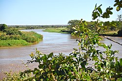
Maputo River in Mozambique
Location
Countries
  • Eswatini
  • Mozambique
  • Physical characteristics
    Source 
     • locationAmsterdam, Mpumalanga, South Africa
    MouthIndian Ocean

     • location

    Maputo Province, Mozambique
    Basin size29,970 km2 (11,570 sq mi)
    Maputo River is located in Mozambique
    Maputo River

    Maputo River

    Location of the Maputo River's mouth

    The Maputo River (Portuguese Rio Maputo), also called Great Usutu River, Lusutfu River, or Suthu River, is a river in South Africa, Eswatini, and Mozambique. The name Suthu refers to Basotho people who lived near the source of the river, but were attacked and displaced by Swazis.[1] It is also said to mean 'dark brown', a description of the river's muddy water.[2]

    Course

    [edit]

    The river rises near Amsterdam, Mpumalanga, South Africa, and flows easterly through Eswatini, where it enters the Lebombo Mountains. The 13 km gorge forms the boundary between Eswatini and South Africa. For approximately twenty kilometres, it forms the border between South Africa (province of KwaZulu-Natal) and Mozambique. There, in the Ndumo Game Reserve, it absorbs its largest tributary, the Pongola River. It then meanders through the Mozambican coastal plain and empties into southern Maputo Bay, some 85 kilometres downstream.[3]

    In Eswatini, the river is called the Great Usutu or Lusutfu and flows through the towns of Bhunya, Luyengo, Siphofaneni, and Big Bend. The town of Big Bend is near a point in which the river meanders abruptly. The Great Usutu is the largest river in Eswatini, it is the site of Eswatini's lowest point (21 m above sea level), and is known for whitewater rafting. No large towns have been able to form along its banks because of deep narrow valleys and dense forests. It is, however, home to some golf courses, hotels, and nature reserves.

    Tributaries

    [edit]

    From the origin to its mouth, in order, tributaries are the: Sihanahana, Bonnie Brook, Mpuluzi, Buhlungu, Umvenvane, Lusushwana, Sidvokodvo, Mkhondvo, Mhlamani, Mzimneni, Mzimphofu, Mhlathuzane, Mtsindzekwa, Nyetane, Funuane, and the Pongola Rivers.[4]

    Dams on this river

    [edit]

    See also

    [edit]

    References

    [edit]
    1. ^ Von Willig, G.R. (1925). Langs die Lebombo. J.L. van Schaik, Pretoria. pp. 175, 217.
  • ^ Raper, P.E. (2004). South African place names. Jonathan Ball, Johannesburg and Cape Town. p. 387. ISBN 1-86842-190-2.
  • ^ Rauken, T.; Kelman, I. (19 October 2010). "River flood vulnerability in Norway through the pressure and release model". Journal of Flood Risk Management. 3 (4): 314–322. doi:10.1111/j.1753-318x.2010.01080.x. ISSN 1753-318X.
  • ^ Usuthu/Mhlatuze WMA 6
  • [edit]


    26°11′S 32°42′E / 26.183°S 32.700°E / -26.183; 32.700


  • t
  • e
  • t
  • e
  • t
  • e
  • t
  • e

  • Retrieved from "https://en.wikipedia.org/w/index.php?title=Maputo_River&oldid=1216107141"

    Categories: 
    Rivers of Mozambique
    Maputo River
    Rivers of Eswatini
    Geography of Maputo
    MozambiqueSouth Africa border
    EswatiniSouth Africa border
    International rivers of Africa
    Border rivers
    Rivers of Mpumalanga
    Lowest points of countries
    Africa river stubs
    Eswatini geography stubs
    Mozambique geography stubs
    Mpumalanga geography stubs
    South Africa river stubs
    Hidden categories: 
    Pages using gadget WikiMiniAtlas
    Use dmy dates from April 2022
    Articles with short description
    Short description is different from Wikidata
    Coordinates on Wikidata
    All stub articles


    This page was last edited on 29 March 2024, at 02:31 (UTC).

    Text is available under the Creative Commons Attribution-ShareAlike License 4.0; additional terms may apply. By using this site, you agree to the Terms of Use and Privacy Policy. Wikipedia® is a registered trademark of the Wikimedia Foundation, Inc., a non-profit organization.


    Privacy policy

    About Wikipedia

    Disclaimers

    Contact Wikipedia

    Code of Conduct

    Developers

    Statistics

    Cookie statement

    Mobile view


    Wikimedia Foundation
    Powered by MediaWiki