Jump to content


Main menu


Navigation  


Main page
Contents
Current events
Random article
About Wikipedia
Contact us
Donate


Contribute  


Help
Learn to edit
Community portal
Recent changes
Upload file


Search  


Create account

Log in


Create account
 Log in


Pages for logged out editors learn more  


Contributions
Talk


Contents


(Top)


1 External links  


Maquan Pond


Add links


Article
Talk


Read
Edit
View history


Tools


Actions  


Read
Edit
View history


General  


What links here
Related changes
Upload file
Special pages
Permanent link
Page information
Cite this page
Get shortened URL
Download QR code
Wikidata item


Print/export  


Download as PDF
Printable version


Appearance


Coordinates: 42°0338N 70°5105W / 42.06056°N 70.85139°W / 42.06056; -70.85139
 

From Wikipedia, the free encyclopedia


Maquan Pond
Maquan Pond
Maquan Pond is located in Massachusetts
Maquan Pond

Maquan Pond

LocationHanson, Massachusetts
Coordinates42°03′38N 70°51′05W / 42.06056°N 70.85139°W / 42.06056; -70.85139
Basin countriesUnited States
Surface area48 acres (19 ha)
Average depth12 ft (3.7 m)
Max. depth18 ft (5.5 m)

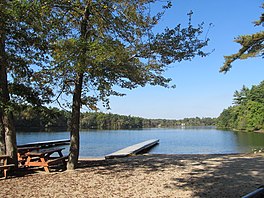
Maquan Pond is a 48-acre (190,000 m2) pond in Hanson, Massachusetts. Its average depth is 12 feet (3.7 m) and its maximum depth is 18 feet (5.5 m). The pond is spring fed with an overflow on the south end that feeds into Indian Head Pond. There has been much development along the shore. The town has a right-of-way on the northern shore of the pond off Maquan Street (Route 14). The town beach Cranberry Cove is at south end of the pond. The water is acidic, so fishing is poor except for pickerel, small yellow perch and pumpkinseeds.

Camp Kiwanee, a former Camp Fire camp, is located on the southeastern shore of the pond. The town now owns the camp and rents camping and cabins as well as Needles Lodge for functions. The Rainbow Girls own land on the southwest shore and previously operated a summer camp there.

[edit]
  • t
  • e

  • Retrieved from "https://en.wikipedia.org/w/index.php?title=Maquan_Pond&oldid=1117761279"

    Categories: 
    Ponds of Plymouth County, Massachusetts
    Ponds of Massachusetts
    Plymouth County, Massachusetts geography stubs
    Hidden categories: 
    Pages using gadget WikiMiniAtlas
    Articles needing additional references from October 2022
    All articles needing additional references
    Coordinates on Wikidata
    Articles using infobox body of water without alt
    Articles using infobox body of water without pushpin map alt
    Articles using infobox body of water without image bathymetry
    All stub articles


    This page was last edited on 23 October 2022, at 12:36 (UTC).

    Text is available under the Creative Commons Attribution-ShareAlike License 4.0; additional terms may apply. By using this site, you agree to the Terms of Use and Privacy Policy. Wikipedia® is a registered trademark of the Wikimedia Foundation, Inc., a non-profit organization.


    Privacy policy

    About Wikipedia

    Disclaimers

    Contact Wikipedia

    Code of Conduct

    Developers

    Statistics

    Cookie statement

    Mobile view


    Wikimedia Foundation
    Powered by MediaWiki