Jump to content


Main menu


Navigation  


Main page
Contents
Current events
Random article
About Wikipedia
Contact us
Donate


Contribute  


Help
Learn to edit
Community portal
Recent changes
Upload file


Search  


Create account

Log in


Create account
 Log in


Pages for logged out editors learn more  


Contributions
Talk


Contents


(Top)


1 History  


2 Administration  


3 Demographics  


4 Economy  


5 Schools  


6 Hospitals  


7 Road Connectivity  


8 Adjacent communities  


9 References  


10 External links  


Marakkanam


 / Bân-lâm-gú
Cebuano
ि
িি ি
Italiano
Bahasa Melayu
Nederlands
 
Português
Srpskohrvatski / српскохрватски
Svenska
ி
Tiếng Vit


Edit links


Article
Talk


Read
Edit
View history


Tools


Actions  


Read
Edit
View history


General  


What links here
Related changes
Upload file
Special pages
Permanent link
Page information
Cite this page
Get shortened URL
Download QR code
Wikidata item


Print/export  


Download as PDF
Printable version


In other projects  


Wikimedia Commons


Appearance


Coordinates: 12°12N 79°57E / 12.2°N 79.95°E / 12.2; 79.95
 

From Wikipedia, the free encyclopedia


Marakkanam
town
Marakkanam is located in Tamil Nadu
Marakkanam

Marakkanam

Location in Tamil Nadu, India

Coordinates: 12°12′N 79°57′E / 12.2°N 79.95°E / 12.2; 79.95

Country

 India

State

Tamil Nadu

District

Viluppuram

Elevation

14 m (46 ft)

Population
 (2011)

 • Total

31,153

Languages

 • Official

Tamil

Time zone

UTC+5:30 (IST)

Vehicle registration

TN-16

Marakkanam is a coastal panchayat town & Taluk in Viluppuram district in the Indian stateofTamil Nadu. It is well connected to the state capital Chennai and the nearby union territory of Puducherry by the East Coast Road. To the west, Marakkanam is connected to the town of Tindivanam by the SH-134. Marakkanam is situated on the declared National Waterways NW-4. On materialisation of National Waterways NW-4, Marakkanam will be connected to two states Andhra Pradesh (Kakinada) and Puducherry through north and south of Buckingham Canal.

Map indicating blocks of Marakkanam Village Panchayat

History[edit]

Marakkanam was connected to Vijayawada in Andhra Pradesh through the Buckingham Canal, a 420 km long fresh water navigation canal. The 110-km stretch from Marakkanam to Chennai is called South Buckingham Canal. The canal connects most of the natural backwaters along the coast to the port of Chennai (Madras). It was constructed by the British Raj, and was an important waterway during the late nineteenth and the twentieth century. Canal was formerly used to convey goods up and down, but later the usage has downgraded due to industrial pollution of water.
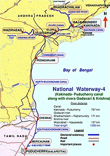
India's National Waterways NW-4 connects Kakinada, in Andhra Pradesh and Pondicherry, in Puducherry. The waterway passes through Rajamundry, Vijayawada, Pedakanjam, Chennai and Marakkanam.

In2013, a violent clash occurred in this town on the basis of caste, in which two people died.

Administration[edit]

Indian Postal code for Marakkanam is 604303.

Marakkanam panchayat town was divided into 56Village Panchayats.The following are the Village Panchayats under Marakkanam

  • Adasal
  • Adavallikoothan
  • Alankuppam
  • Alapakkam
  • Alathur
  • Annamputhur
  • Anumandai
  • Asappur
  • Athur
  • Brammadesam
  • Chettikuppam
  • Cheyyankuppam
  • Ekkiyarkuppam
  • Endiyur
  • Endur
  • Eraiyanur
  • kazhikuppam
  • Jaggampettai
  • Kandadu
  • Kattalai
  • kaippani nagar
  • Kilarungunam
  • Kiledaiyalam
  • Kilpettai
  • Kilputhuppattu
  • Kilsithamur
  • Kilsiviri
  • Kolathur
  • Koonimedu
  • Kovadi
  • Kurur
  • Manur
  • Molasur
  • Munnur
  • Nadukuppam
  • K.N Palayam
  • pudhuppakkam
  • Kandadu
  • Nagalpakkam
  • Nagar
  • Nallalam.t
  • Nallur
  • Nalmukkal
  • mandur
  • Omippair
  • Panichamedu
  • Perumukkal
  • Pudhupakkam.m
  • Salavadi
  • Singanur
  • Thenkalavaii
  • Thennerkunam
  • Thenpasar
  • Urani
  • Vada Nerkunam
  • Vadaalappakkam
  • Vadakottippakkam
  • Vaidappakkam
  • Vannippair
  • Vengai
  • Vittalapuram
  • Siruvadi
  • Demographics[edit]

    As of 2001 India census,[1] Marakkanam had a population of 19,153. Males constitute 50% of the population and females 50%. Marakkanam has an average literacy rate of 61%, higher than the national average of 59.5%: male literacy is 70%, and female literacy is 52%. In Marakkanam, 13% of the population is under 6 years of age.

    Economy[edit]

    Salt Production at Salt pans of Marakkanam

    Schools[edit]

    Hospitals[edit]

    Government Hospital, Marakkanam (Near ECR bypass)

    Road Connectivity[edit]

    Adjacent communities[edit]

    [icon]

    This section needs expansion. You can help by adding to it. (November 2021)

    Marakkanam

    References[edit]

    1. ^ "Census of India 2001: Data from the 2001 Census, including cities, villages and towns (Provisional)". Census Commission of India. Archived from the original on 16 June 2004. Retrieved 1 November 2008.

    External links[edit]

    Taluks

  • Kandachipuram
  • Marakkanam
  • Melmalayanur
  • Tindivanam
  • Tiruvennainallur
  • Vanur
  • Vikravandi
  • Villupuram
  • Revenue
    divisions

  • Viluppuram
  • Revenue
    blocks

  • Kanai
  • Kandamangalam
  • Koliyanur
  • Mailam
  • Marakkanam
  • Melmalayanur
  • Mugaiyur
  • Olakkur
  • Tirunavalur
  • Vallam
  • Vanur
  • Vikravandi
  • Cities and
    towns

  • Arakandanallur
  • Auroville
  • Gingee
  • Kiliyanur
  • Kottakuppam
  • Marakkanam
  • Melmalayanur
  • Melmaruvathur
  • Olakur
  • Thennamadevi
  • Thiruvennainallur
  • Tindivanam
  • Valavanur
  • Veerabayangaram
  • Veerapondi
  • Vikravandi
  • Viluppuram (district headquarters)
  • See also: List of villages in Viluppuram district

    National highways

  • NH 716
  • NH 716A
  • NH 32
  • NH 132
  • NH 132B
  • NH 332
  • NH 332A
  • NH 532
  • NH 36
  • NH 136
  • NH 136B
  • NH 336
  • NH 536
  • NH 38
  • NH 138
  • NH 338
  • NH 40
  • NH 42
  • NH 44
  • NH 544
  • NH 544H
  • NH 744
  • NH 844
  • NH 944
  • NH 48
  • NH 648
  • NH 948
  • NH 66
  • NH 75
  • NH 77
  • NH 79
  • NH 179A
  • NH 179D
  • NH 81
  • NH 181
  • NH 381
  • NH 381A
  • NH 381B
  • NH 83
  • NH 183
  • NH 383
  • NH 85
  • NH 785
  • NH 87
  • State highways

  • SH 4
  • SH 6
  • SH 9
  • SH 10
  • SH 15
  • SH 19
  • SH 20
  • SH 22
  • SH 25
  • SH 26
  • SH 30
  • SH 49
  • SH 49A
  • SH 58
  • SH 60
  • SH 62
  • SH 68
  • SH 71
  • SH 71A
  • SH 81
  • SH 83A
  • SH 84
  • SH 84A
  • SH 96
  • SH 109
  • SH 113
  • SH 115
  • SH 134
  • SH 142
  • SH 156
  • SH 161
  • SH 173
  • SH 190
  • SH 234
  • See also

  • Golden Quadrilateral
  • North–South and East–West Corridor
  • Chennai Bypass Road
  • Chennai HSCTC
  • Coimbatore bypass
  • List
  • Waterways in India

    National Waterways (list)

  • 2
  • 3
  • 4
  • 5
  • 6
  • Regulatory Body

    Legislations


    Retrieved from "https://en.wikipedia.org/w/index.php?title=Marakkanam&oldid=1187584430"

    Category: 
    Cities and towns in Viluppuram district
    Hidden categories: 
    Pages using gadget WikiMiniAtlas
    Articles with short description
    Short description is different from Wikidata
    Use dmy dates from September 2015
    Use Indian English from September 2015
    All Wikipedia articles written in Indian English
    Coordinates on Wikidata
    Articles containing potentially dated statements from 2001
    All articles containing potentially dated statements
    Articles to be expanded from November 2021
    All articles to be expanded
    Articles using small message boxes
    Commons category link is on Wikidata


    This page was last edited on 30 November 2023, at 04:01 (UTC).

    Text is available under the Creative Commons Attribution-ShareAlike License 4.0; additional terms may apply. By using this site, you agree to the Terms of Use and Privacy Policy. Wikipedia® is a registered trademark of the Wikimedia Foundation, Inc., a non-profit organization.


    Privacy policy

    About Wikipedia

    Disclaimers

    Contact Wikipedia

    Code of Conduct

    Developers

    Statistics

    Cookie statement

    Mobile view


    Wikimedia Foundation
    Powered by MediaWiki