Jump to content


Main menu


Navigation  


Main page
Contents
Current events
Random article
About Wikipedia
Contact us
Donate


Contribute  


Help
Learn to edit
Community portal
Recent changes
Upload file


Search  


Create account

Log in


Create account
 Log in


Pages for logged out editors learn more  


Contributions
Talk


Contents


(Top)


1 Description  


2 Maramec Iron Works  


3 Recreational activities  


4 See also  


5 References  


6 External links  


Maramec Spring


Cebuano
Deutsch
 

Edit links


Article
Talk


Read
Edit
View history


Tools


Actions  


Read
Edit
View history


General  


What links here
Related changes
Upload file
Special pages
Permanent link
Page information
Cite this page
Get shortened URL
Download QR code
Wikidata item


Print/export  


Download as PDF
Printable version


In other projects  


Wikimedia Commons


Appearance


Coordinates: 37°5720N 91°3157W / 37.95556°N 91.53250°W / 37.95556; -91.53250
 

From Wikipedia, the free encyclopedia


Maramec Spring
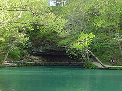
The spring discharges below an overhanging bluff of Gasconade Dolomite.
Location
CountryUnited States
StateMissouri
RegionOzark Plateau
CountyPhelps
Physical characteristics
SourceDry Fork watershed
 • locationSalem Plateau, Ozark Plateau, Missouri
 • elevation773.97 ft (235.91 m)USGS
MouthMeramec River

 • location

near St. James, Phelps County, Ozark Plateau, Missouri

 • coordinates

37°57′20N 91°31′57W / 37.95556°N 91.53250°W / 37.95556; -91.53250[1]
Length0.87 mi (1.40 km)[2]
Discharge 
 • locationMaramec Spring[3]
 • average153 cu ft/s (4.3 m3/s)[3]
 • maximum770 cu ft/s (22 m3/s)
Basin features
U.S. NNLDesignated: 1971

Maramec Iron Works District

U.S. National Register of Historic Places

U.S. Historic district

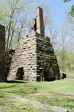
The remains of an iron furnace of the Maramec Iron Works which used hydropower from the spring
Nearest citySt. James, Missouri
Area0 acres (0 ha)
Built1826 (1826)
NRHP reference No.69000122[4]
Added to NRHPApril 16, 1969
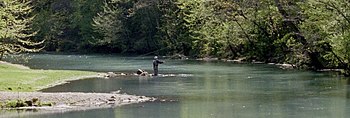
Trout fishing is popular in the branch from Maramec Spring to the river.

Maramec Spring is located on the Meramec River near St. James in the east-central OzarksofMissouri. The fifth largest spring in the state with an average discharge of 153 cubic feet (4.3 m3) of water per second, it is part of a Karst topographical area, with many springs and caves. The spring and 1800 acres (7.28 km²) are owned by the James Foundation, which maintains the area as a public park, donated by Lucy Wortham James. The Missouri Department of Conservation operates a trout hatchery and fishery at the spring. Ruins of the Maramec Iron Works are still visible at the site; its machinery was partly powered by the spring's waterflow. The spring was declared a National Natural Landmark in October 1971.[5]

Description

[edit]

The spring's daily discharge averages nearly 100 million gallons (363 million liters).[1] The history of the spring and the iron works is explained in a museum operated by the James Foundation at the site. Another museum in the park features agricultural tools utilized in the area over the years.

The park contains a drive that offers a glimpse into the life in the area while the iron works were operating. It includes a scenic overview of the park, a cemetery which serves as the final resting place of some employees of the iron works, the iron pit mine, and locations of a few homesteads. The park hosts several picnic areas, including pavilions suitable for events.

Maramec Iron Works

[edit]

Adjacent to the spring are the ruins of the Maramec Iron Works. The first commercially viable iron facility in the US west of the Mississippi, it produced iron from 1827 to 1891. During the US Civil War, it produced iron for cannonballs and James B. Eads' gunships, which were built in St. Louis near the mouth of the river. The iron works used the spring's flow to power its machinery, processing high-grade hematite from a nearby pit.[6][7][8] The Maramec Iron Works District was listed on the National Register of Historic Places in 1969.[4]

The James Foundation hosts an annual Old Iron Works Days on a weekend in October. It features arts, crafts, foods, displays and presentations of life in the area during the era of the iron works.

Recreational activities

[edit]

The park is one of four trout parks in Missouri, providing near year-round fishing. Harvesting season runs from March until October, while the catch and release season runs during the winter months. The stream is restocked every day during fishing season from the 100,000 trout produced annually by the hatchery.[9]

There are 58 campsites in the park, including ten with electric hook-ups. The park has numerous picnic sites, six reserveable picnic shelters, and multiple playgrounds.[10]

See also

[edit]

References

[edit]
  • ^ a b USGS 1923-1985
  • ^ a b "National Register Information System". National Register of Historic Places. National Park Service. July 9, 2010.
  • ^ "National Natural Landmark summary". National Park Service. February 5, 2004. Retrieved April 26, 2009.
  • ^ Norris, James D., “Frontier Iron: The Story of The Maramec Iron Works: 1826-76," State Historical Society of Wisconsin, 1964, James Foundation paperback reprint, 1972.
  • ^ Ludwig, Stephen (1977). "Maramec Iron Works". Bittersweet. 2 (2). Lebanon High School. Retrieved April 26, 2009.
  • ^ Martha L. Kusiak (March 1969). "National Register of Historic Places Inventory Nomination Form: Maramec Iron Works District" (PDF). Missouri Department of Natural Resources. Retrieved February 1, 2017.
  • ^ "Maramec Spring Fish Hatchery and Trout Park". Missouri Department of Conservation. 2009. Archived from the original on January 13, 2009. Retrieved April 26, 2009.
  • ^ "Camping at Maramec Spring Park along the Meramec River". James Foundation. Archived from the original on March 1, 2010. Retrieved December 15, 2009.
  • [edit]
    Retrieved from "https://en.wikipedia.org/w/index.php?title=Maramec_Spring&oldid=1169249853"

    Categories: 
    National Natural Landmarks in Missouri
    Protected areas of Phelps County, Missouri
    Springs of Missouri
    Bodies of water of Phelps County, Missouri
    Historic districts on the National Register of Historic Places in Missouri
    Archaeological sites on the National Register of Historic Places in Missouri
    Buildings and structures in Phelps County, Missouri
    National Register of Historic Places in Phelps County, Missouri
    Hidden categories: 
    Pages using gadget WikiMiniAtlas
    Articles using NRISref without a reference number
    Use mdy dates from August 2023
    Articles with short description
    Short description is different from Wikidata
    Coordinates on Wikidata
    NRHP infobox with nocat
    Commons category link is on Wikidata
    Articles with VIAF identifiers
    Articles with J9U identifiers
    Articles with LCCN identifiers


    This page was last edited on 8 August 2023, at 00:31 (UTC).

    Text is available under the Creative Commons Attribution-ShareAlike License 4.0; additional terms may apply. By using this site, you agree to the Terms of Use and Privacy Policy. Wikipedia® is a registered trademark of the Wikimedia Foundation, Inc., a non-profit organization.


    Privacy policy

    About Wikipedia

    Disclaimers

    Contact Wikipedia

    Code of Conduct

    Developers

    Statistics

    Cookie statement

    Mobile view


    Wikimedia Foundation
    Powered by MediaWiki