Jump to content


Main menu


Navigation  


Main page
Contents
Current events
Random article
About Wikipedia
Contact us
Donate


Contribute  


Help
Learn to edit
Community portal
Recent changes
Upload file


Search  


Create account

Log in


Create account
 Log in


Pages for logged out editors learn more  


Contributions
Talk


Contents


(Top)


1 Notes  


2 References  


3 External links  


Markala


العربية
 / Bân-lâm-gú
Català
Cebuano
Español
Esperanto
Français
Italiano
Magyar
مصرى
Nederlands
Oʻzbekcha / ўзбекча
Polski
Русский
Suomi
Svenska


Edit links


Article
Talk


Read
Edit
View history


Tools


Actions  


Read
Edit
View history


General  


What links here
Related changes
Upload file
Special pages
Permanent link
Page information
Cite this page
Get shortened URL
Download QR code
Wikidata item


Print/export  


Download as PDF
Printable version


In other projects  


Wikimedia Commons


Appearance


Coordinates: 13°4026N 6°430W / 13.67389°N 6.07500°W / 13.67389; -6.07500
 

From Wikipedia, the free encyclopedia


Markala
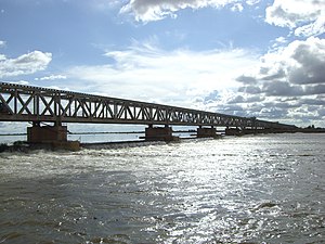
The Markala dam
The Markala dam
Markala is located in Mali
Markala

Markala

Location in Mali

Coordinates: 13°40′26N 6°4′30W / 13.67389°N 6.07500°W / 13.67389; -6.07500
Country Mali
RegionSégou Region
CercleSégou Cercle
Area
 • Total318 km2 (123 sq mi)
Elevation
283 m (928 ft)
Population
 (2009 census)[2]
 • Total45,961
 • Density140/km2 (370/sq mi)
Time zoneUTC+0 (GMT)

Markala is a communeinMali's Ségou Region on the Niger River 35 km down stream from the town of Ségou. The commune contains 30 villages in an area of 318 square kilometers and in 2009 had a population of 45,961.[2][3] Mali's primary irrigation dam, the Markala dam, lies in the commune. The main village of the commune, Diamarabougou, is on the right bank adjacent to the dam which also serves as an important road bridge.

The French colonial authorities constructed the dam between 1934 and 1945 to irrigate farmland with the intention of producing cotton for the textile industry.[4] The dam is 2450 m in length and functions as a weir in that water can flow over the top. It diverts water into a canal system that extends 135 km to the north past the small towns of Niono and Sokolo in the 'Delta Mort' region. Each year around 2.7 km3 of water is diverted from the river, which corresponds to 8.3 percent of the total flow.[4] The water is used to irrigate about 750 square kilometers (75,000 ha) of farmland. The scheme is managed by the Office du Niger and in 1999/2000 produced 320,000 tons of rice, representing 40 percent of the total Malian production.[5]

Although the dam itself lies in the centre of the Markala commune, the farmland irrigated by the dam lies outside the commune to the north.

Until around 2008, the town was served by Markala Airport.

Notes

[edit]
  1. ^ "Mali - COD-FOD Registry". 6 January 2012. Archived from the original on 6 January 2012. Retrieved 30 September 2017.{{cite web}}: CS1 maint: bot: original URL status unknown (link)
  • ^ a b Resultats Provisoires RGPH 2009 (Région de Ségou) (PDF) (in French), République de Mali: Institut National de la Statistique, archived from the original (PDF) on 2011-07-22.
  • ^ Communes de la Région de Ségou (PDF) (in French), Ministère de l’administration territoriale et des collectivités locales, République du Mali, archived from the original (PDF) on 2012-03-09.
  • ^ a b Zwarts et al. 2005, p. 26.
  • ^ Zwarts et al. 2005, p. 189.
  • References

    [edit]
    [edit]
    Retrieved from "https://en.wikipedia.org/w/index.php?title=Markala&oldid=1095040052"

    Categories: 
    Communities on the Niger River
    Communes of Ségou Region
    Hidden categories: 
    Pages using gadget WikiMiniAtlas
    CS1 maint: bot: original URL status unknown
    CS1 French-language sources (fr)
    Articles with short description
    Short description is different from Wikidata
    Coordinates on Wikidata
    All articles with dead external links
    Articles with dead external links from March 2020
    Articles with permanently dead external links
    Commons category link from Wikidata
    Articles with VIAF identifiers
    Articles with BNF identifiers
    Articles with BNFdata identifiers
    Articles with J9U identifiers
    Articles with LCCN identifiers


    This page was last edited on 26 June 2022, at 01:39 (UTC).

    Text is available under the Creative Commons Attribution-ShareAlike License 4.0; additional terms may apply. By using this site, you agree to the Terms of Use and Privacy Policy. Wikipedia® is a registered trademark of the Wikimedia Foundation, Inc., a non-profit organization.


    Privacy policy

    About Wikipedia

    Disclaimers

    Contact Wikipedia

    Code of Conduct

    Developers

    Statistics

    Cookie statement

    Mobile view


    Wikimedia Foundation
    Powered by MediaWiki