Jump to content


Main menu


Navigation  


Main page
Contents
Current events
Random article
About Wikipedia
Contact us
Donate


Contribute  


Help
Learn to edit
Community portal
Recent changes
Upload file


Search  


Create account

Log in


Create account
 Log in


Pages for logged out editors learn more  


Contributions
Talk


Contents


(Top)


1 Location  


2 Economy  


3 Municipal Human Development Index  


4 See also  


5 References  


6 External links  


Mato Verde


 / Bân-lâm-gú
Cebuano
Español
Esperanto
Euskara
Français
িি ি
Italiano

Қазақша
Malagasy
Nederlands
Нохчийн
Norsk bokmål
Polski
Português
Română
Русский
Svenska
Татарча / tatarça
Tiếng Vit
Winaray


Edit links


Article
Talk


Read
Edit
View history


Tools


Actions  


Read
Edit
View history


General  


What links here
Related changes
Upload file
Special pages
Permanent link
Page information
Cite this page
Get shortened URL
Download QR code
Wikidata item


Print/export  


Download as PDF
Printable version


In other projects  


Wikimedia Commons


Appearance


Coordinates: 15°2353S 42°5124W / 15.39806°S 42.85667°W / -15.39806; -42.85667
 

From Wikipedia, the free encyclopedia


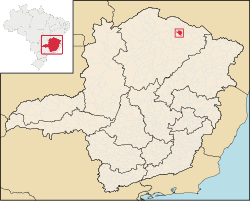
Location of Mato Verde in the state of Minas Gerais

Mato Verde is a municipality located in the north of the state of Minas GeraisinBrazil. It was founded in 1953. The population was 12,412 as of 2020 and the area was 664 km².[1] The elevation of the city is 541 metres. The postal code (CEP) is 39527-000.

Location

[edit]

Mato Verde is part of the statistical microregion of Janaúba. It is surrounded by the following municipalities: Monte Azul, Porteirinha, Rio Pardo de Minas, Catuti and Pai Pedro. It is connected by paved road (BR-122) to the regional center of Janaúba to the south. The distance is 80 km. To the north lies the municipality of Monte Azul, a distance of 32 km. The distance to the state capital, Belo Horizonte, is 504 km. The distance to Montes Claros is 226 kilometres (140 mi).

The municipality contains part of the 49,830 hectares (123,100 acres) Serra Nova State Park, created in 2003.[2] The most important touristic site is the waterfall called Cachoeira de Maria Rosa, which is located 12 kilometers from the urban area.

Economy

[edit]

Inadequate rainfall, isolation, and poor soils make this one of the poorest municipalities in the state and in the country. The main economic activities are cattle raising (13,500 head in 2006) and farming with modest production of cotton, rice, beans, corn, and sorghum. In 2006 there were 1,002 rural producers with a total area of 39,851 hectares. Cropland made up 4,300 hectares and natural pasture 24,500 hectares. There were only 56 tractors a ratio of one for every 200 farms. In the urban area there was one financial institution as of 2006. There were 668 automobiles, giving a ratio of about one automobile for every 19 inhabitants. The Gross Domestic Product was R$38,291,000 (2005). Health care was provided by 9 public health clinics. There was one hospital with 17 beds.

[edit]

See also

[edit]

References

[edit]
  • ^ Diniz, Ana Elizabeth (5 November 2009), "Parque Estadual de Serra Nova: natureza mágica", Revista Ecológico (in Portuguese), retrieved 2017-01-30
  • [edit]

    15°23′53S 42°51′24W / 15.39806°S 42.85667°W / -15.39806; -42.85667


    Retrieved from "https://en.wikipedia.org/w/index.php?title=Mato_Verde&oldid=1120165198"

    Category: 
    Municipalities in Minas Gerais
    Hidden categories: 
    CS1 Portuguese-language sources (pt)
    Pages using gadget WikiMiniAtlas
    Articles with short description
    Short description is different from Wikidata
    Coordinates on Wikidata


    This page was last edited on 5 November 2022, at 14:21 (UTC).

    Text is available under the Creative Commons Attribution-ShareAlike License 4.0; additional terms may apply. By using this site, you agree to the Terms of Use and Privacy Policy. Wikipedia® is a registered trademark of the Wikimedia Foundation, Inc., a non-profit organization.


    Privacy policy

    About Wikipedia

    Disclaimers

    Contact Wikipedia

    Code of Conduct

    Developers

    Statistics

    Cookie statement

    Mobile view


    Wikimedia Foundation
    Powered by MediaWiki