Jump to content


Main menu


Navigation  


Main page
Contents
Current events
Random article
About Wikipedia
Contact us
Donate


Contribute  


Help
Learn to edit
Community portal
Recent changes
Upload file


Search  


Create account

Log in


Create account
 Log in


Pages for logged out editors learn more  


Contributions
Talk


Contents


(Top)


1 Administrative divisions  


1.1  Regional county municipalities  


1.2  Equivalent territories  


1.3  Independent municipalities  


2 Nation Atikamekw  


3 Major communities  


4 School districts  


5 Notable people  


6 References  


7 External links  


Mauricie


Afrikaans
 / Bân-lâm-gú
Català
Cebuano
Deutsch
Eesti
Español
Esperanto
Euskara
فارسی
Français
/Hak-kâ-ngî
Italiano
Latina
مصرى
Nederlands

Norsk bokmål
Occitan
Polski
Português
Русский
Scots
Shqip
Suomi
Svenska
Українська


Edit links


Article
Talk


Read
Edit
View history


Tools


Actions  


Read
Edit
View history


General  


What links here
Related changes
Upload file
Special pages
Permanent link
Page information
Cite this page
Get shortened URL
Download QR code
Wikidata item


Print/export  


Download as PDF
Printable version


In other projects  


Wikimedia Commons
Wikivoyage


Appearance


Coordinates: 47°00N 73°00W / 47.000°N 73.000°W / 47.000; -73.000
 

From Wikipedia, the free encyclopedia


Mauricie
Coordinates: 47°00′N 73°00′W / 47.000°N 73.000°W / 47.000; -73.000
CountryCanada Canada
ProvinceQuebec Quebec
Regional County Municipalities (RCM) and Equivalent Territories (ET)

3 RCM, 3 ET

Government
 • Table des élus de la Mauricie (Regional conference of elected officers)Gérard Bruneau (President)
Area
 • Land35,860.05 km2 (13,845.64 sq mi)
Population
 (2016)[1]
 • Total266,112
 • Density7.4/km2 (19/sq mi)
 • Change 2011-2016
Increase 1.0%
Time zoneUTC-5 (EST)
 • Summer (DST)UTC-4 (EDT)
Postal code
G
Area code819, 873
Websitewww.mauricie.gouv.qc.ca

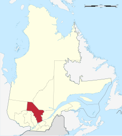
Mauricie (French pronunciation: [mɔʁisi]) is a traditional and current administrative region of Quebec. La Mauricie National Park is contained within the region, making tourism in Mauricie popular. The region has a land area of 35,860.05 km2 (13,845.64 sq mi) and a population of 266,112 residents as of the 2016 Census.[1] Its largest cities are Trois-Rivières and Shawinigan.

The word Mauricie was coined by local priest and historian Albert Tessier and is based on the Saint-Maurice river which runs through the region on a North-South axis.

Mauricie administrative region was created on August 20, 1997 from the split of Mauricie–Bois-Francs administrative region into Mauricie and Centre-du-Québec.[2] However, the concept of Mauricie as a traditional region long predates this.

Administrative divisions[edit]

Regional county municipalities[edit]

Equivalent territories[edit]

Independent municipalities[edit]

Nation Atikamekw[edit]

Major communities[edit]

School districts[edit]

10 Francophones:

Part of Anglophone:

Notable people[edit]

References[edit]

  1. ^ a b c "Census Profile, 2016 Census Mauricie [Economic region], Quebec". Statistics Canada. 8 February 2017. Retrieved November 22, 2019.
  • ^ "Modifications aux municipalités du Québec" (PDF). Bureau de la statistique du Québec. August 1997. ISSN 0843-8250. Retrieved 2012-05-20.[permanent dead link]
  • ^ "Mauricie (Code 2470) Census Profile". 2011 census. Government of Canada - Statistics Canada.
  • External links[edit]


    Retrieved from "https://en.wikipedia.org/w/index.php?title=Mauricie&oldid=1218532794"

    Categories: 
    Mauricie
    Administrative regions of Quebec
    Hidden categories: 
    Pages using gadget WikiMiniAtlas
    Pages with non-numeric formatnum arguments
    All articles with dead external links
    Articles with dead external links from June 2017
    Articles with permanently dead external links
    Articles with short description
    Short description matches Wikidata
    Coordinates on Wikidata
    Pages with French IPA
    Commons category link from Wikidata
    Articles with FAST identifiers
    Articles with VIAF identifiers
    Articles with WorldCat Entities identifiers
    Articles with BNF identifiers
    Articles with BNFdata identifiers
    Articles with J9U identifiers
    Articles with LCCN identifiers
    Articles with MusicBrainz area identifiers
    Articles with SUDOC identifiers


    This page was last edited on 12 April 2024, at 08:06 (UTC).

    Text is available under the Creative Commons Attribution-ShareAlike License 4.0; additional terms may apply. By using this site, you agree to the Terms of Use and Privacy Policy. Wikipedia® is a registered trademark of the Wikimedia Foundation, Inc., a non-profit organization.


    Privacy policy

    About Wikipedia

    Disclaimers

    Contact Wikipedia

    Code of Conduct

    Developers

    Statistics

    Cookie statement

    Mobile view


    Wikimedia Foundation
    Powered by MediaWiki