Jump to content


Main menu


Navigation  


Main page
Contents
Current events
Random article
About Wikipedia
Contact us
Donate


Contribute  


Help
Learn to edit
Community portal
Recent changes
Upload file


Search  


Create account

Log in


Create account
 Log in


Pages for logged out editors learn more  


Contributions
Talk


Contents


(Top)


1 References  


Meilahti


Eesti
Español
Euskara
فارسی
Français
Suomi
Svenska


Edit links


Article
Talk


Read
Edit
View history


Tools


Actions  


Read
Edit
View history


General  


What links here
Related changes
Upload file
Special pages
Permanent link
Page information
Cite this page
Get shortened URL
Download QR code
Wikidata item


Print/export  


Download as PDF
Printable version


In other projects  


Wikimedia Commons


Appearance


Coordinates: 60°11N 24°54E / 60.183°N 24.900°E / 60.183; 24.900
 

From Wikipedia, the free encyclopedia


Meilahti
Mejlans
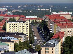
View along Mannerheimintie with apartment buildings of Meilahti to the left, and those of Laakso to the right
Position of Meilahti within Helsinki
Country Finland
RegionUusimaa
Sub-regionGreater Helsinki
MunicipalityHelsinki
DistrictWestern
Area
2.12 km2 (0.82 sq mi)
Population
6,792
 • Density3,090/km2 (8,000/sq mi)
Postal codes
00270, 00250
Subdivision number15
Neighbouring subdivisionsVanha Munkkiniemi, Laakso, Ruskeasuo, Kuusisaari, Lehtisaari, Taka-Töölö, Etu-Töölö

Meilahti (inSwedish Mejlans) is a neighbourhoodofHelsinki between Mannerheimintie (the main entrance road to Helsinki) and a bay named Seurasaarenselkä. Most of the houses in Meilahti were built in the 1930s and 1940s. Meilahti is home to over 6700 people. Meilahti is the location of Mäntyniemi, official residence of the President of Finland, as well as Kesäranta, the official residence of Prime Minister of Finland. Near Mäntyniemi is the former presidential residence, Tamminiemi, which is today a museum dedicated to president Urho Kekkonen.

Several hospitals are located in this district, including the Meilahti Hospital of the Helsinki University Central Hospital (HUCH).

Neighbourhoods surrounding Meilahti are Töölö, Munkkiniemi, Ruskeasuo, Pikku Huopalahti and Laakso.

For the 1952 Summer Olympics, the neighborhood hosted the rowing events.

St. Mary's Church in Meilahti

References

[edit]

60°11′N 24°54′E / 60.183°N 24.900°E / 60.183; 24.900


  • t
  • e
  • t
  • e

  • Retrieved from "https://en.wikipedia.org/w/index.php?title=Meilahti&oldid=1085301534"

    Categories: 
    Meilahti
    Venues of the 1952 Summer Olympics
    Olympic rowing venues
    Southern Finland Province geography stubs
    Summer Olympic venue stubs
    Hidden categories: 
    Pages using gadget WikiMiniAtlas
    Articles lacking in-text citations from January 2020
    All articles lacking in-text citations
    Articles with short description
    Short description is different from Wikidata
    Articles containing Finnish-language text
    Articles containing Swedish-language text
    Pages using infobox settlement with no coordinates
    Coordinates on Wikidata
    Commons category link is on Wikidata
    All stub articles


    This page was last edited on 29 April 2022, at 17:46 (UTC).

    Text is available under the Creative Commons Attribution-ShareAlike License 4.0; additional terms may apply. By using this site, you agree to the Terms of Use and Privacy Policy. Wikipedia® is a registered trademark of the Wikimedia Foundation, Inc., a non-profit organization.


    Privacy policy

    About Wikipedia

    Disclaimers

    Contact Wikipedia

    Code of Conduct

    Developers

    Statistics

    Cookie statement

    Mobile view


    Wikimedia Foundation
    Powered by MediaWiki