Jump to content


Main menu


Navigation  


Main page
Contents
Current events
Random article
About Wikipedia
Contact us
Donate


Contribute  


Help
Learn to edit
Community portal
Recent changes
Upload file


Search  


Create account

Log in


Create account
 Log in


Pages for logged out editors learn more  


Contributions
Talk


Contents


(Top)


1 Gauge  


2 Abbreviation  


3 Height differences between Austria and neighbouring countries  


4 See also  


5 References  


6 External links  


Metres above the Adriatic


Boarisch
Bosanski
Čeština
Deutsch
Español
Hrvatski
Lëtzebuergesch
Nederlands
 

Edit links


Article
Talk


Read
Edit
View history


Tools


Actions  


Read
Edit
View history


General  


What links here
Related changes
Upload file
Special pages
Permanent link
Page information
Cite this page
Get shortened URL
Download QR code
Wikidata item


Print/export  


Download as PDF
Printable version


Appearance


Coordinates: 45°3849N 13°4536E / 45.646867°N 13.759867°E / 45.646867; 13.759867
 

From Wikipedia, the free encyclopedia


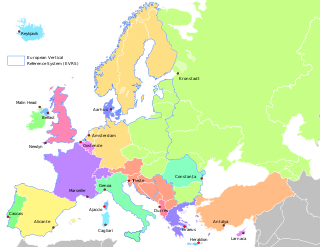
Map of the various vertical reference areas in Europe.
  Countries using the Adriatic datum

Metres above the Adriatic (Italian: Metri sopra l'Adriatico, German: Meter über Adria, Serbo-Croatian: Metara iznad Jadrana) is the vertical datum used in Albania, Austria, Bosnia and Herzegovina, Croatia, Montenegro, North Macedonia, Serbia, and Slovenia to measure elevation, referring to the average water level of the Adriatic Sea at the Sartorio mole in the Port of Trieste.

Gauge[edit]

Benchmark (1888) in Salzburg
Instrument building of the Austro-Hungarian tide gauging station at Molo Sartorio in Trieste
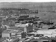
Port of Trieste, about 1885

The gauging station in the Port of Trieste was established in 1875 by the local observatory run by the military geographical institute of the Austro-Hungarian Army. The average water surface elevation at Molo Sartorio became the datum valid for the whole Austro-Hungarian monarchy. Whilst the former Yugoslavian states still use it, the Eastern Bloc successor states of Austria-Hungary like Hungary and Czechoslovakia after World War II switched to the Kronstadt Gauge of the Baltic Sea, which is 0.6747 m (2.214 ft) higher.

Whilst for Austria the 1875 gauge is used as the datum, the states of former Yugoslavia use the 1900 gauge (Nadmorska visina, m/nv). In Albania (normal-orthometric height) they also refer to heights as 'metres above the Adriatic', but use a specific tide gauge in the port of Durrës.

Abbreviation[edit]

The individual countries using this datum abbreviate it in different ways depending on their local language, as follows:

'Metres above the Adriatic' may be abbreviated in English to m AA

Height differences between Austria and neighbouring countries[edit]

In Austria orthometric height is used, while its neighbours use other height systems, which leads to differences. On the state borders these differences are:

(Differences: HAustria − Hneighbouring states)[2]

See also[edit]

References[edit]

  1. ^ "S pomočjo mareografske postaje v Kopru do novega geodetskega izhodišča za Slovenijo" [With the Help of a Tide Gauge Station in Koper to A New Geodetic Origin Point for Slovenia] (in Slovenian). Slovenian Environment Agency. 23 November 2016.
  • ^ Map with height differences by the Austrian federal office for metrology and surveying, Bundesamt für Eich- und Vermessungswesen
  • External links[edit]

    45°38′49N 13°45′36E / 45.646867°N 13.759867°E / 45.646867; 13.759867


    Retrieved from "https://en.wikipedia.org/w/index.php?title=Metres_above_the_Adriatic&oldid=1232243709"

    Categories: 
    Vertical datums
    Geography of Austria
    Adriatic Sea
    Zero-level elevation points
    Hidden categories: 
    CS1 Slovenian-language sources (sl)
    Pages using gadget WikiMiniAtlas
    Articles with short description
    Short description is different from Wikidata
    Articles containing Italian-language text
    Articles containing German-language text
    Articles containing Hungarian-language text
    Articles with Italian-language sources (it)
    Articles with German-language sources (de)
    Webarchive template wayback links
    Coordinates on Wikidata


    This page was last edited on 2 July 2024, at 18:38 (UTC).

    Text is available under the Creative Commons Attribution-ShareAlike License 4.0; additional terms may apply. By using this site, you agree to the Terms of Use and Privacy Policy. Wikipedia® is a registered trademark of the Wikimedia Foundation, Inc., a non-profit organization.


    Privacy policy

    About Wikipedia

    Disclaimers

    Contact Wikipedia

    Code of Conduct

    Developers

    Statistics

    Cookie statement

    Mobile view


    Wikimedia Foundation
    Powered by MediaWiki