Jump to content


Main menu


Navigation  


Main page
Contents
Current events
Random article
About Wikipedia
Contact us
Donate


Contribute  


Help
Learn to edit
Community portal
Recent changes
Upload file


Search  


Create account

Log in


Create account
 Log in


Pages for logged out editors learn more  


Contributions
Talk


Contents


(Top)


1 History  


1.1  18th century  


1.2  Contemporary  


2 See also  


3 References  


Mirów, Warsaw


Polski
Tiếng Vit
 

Edit links


Article
Talk


Read
Edit
View history


Tools


Actions  


Read
Edit
View history


General  


What links here
Related changes
Upload file
Special pages
Permanent link
Page information
Cite this page
Get shortened URL
Download QR code
Wikidata item


Print/export  


Download as PDF
Printable version


In other projects  


Wikimedia Commons


Appearance


Coordinates: 52°1356N 20°5928E / 52.23222°N 20.99111°E / 52.23222; 20.99111
 

From Wikipedia, the free encyclopedia


Mirów
Warsaw neighbourhood
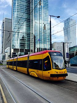
Tram on Prosta Street
Location of Mirów neighbourhood (red) in the District of Wola (navy blue)
Coordinates: 52°13′56N 20°59′28E / 52.23222°N 20.99111°E / 52.23222; 20.99111
Country Poland
VoivodeshipMasovian
County/CityWarsaw
DistrictWola
Time zoneUTC+1 (CET)
 • Summer (DST)UTC+2 (CEST)

Mirów (Polish pronunciation: [ˈmiruf]) is one of the central neighbourhoods in the Wola district of Warsaw, the capital of Poland.

History[edit]

The neighbourhood is situated between Towarowa Street to west, Solidarity Avenue to the north, John Paul II Avenue to the east and Jerusalem Avenue to the south. The principal thoroughfare of the area is Prosta Street.

18th century[edit]

The present-day territory of Mirów was once occupied by a jurydyka called Wielopole,[1] a self-governing town and exclave of Warsaw, just outside the city's borders.[2] By the 18th century, the town lost its independent status and was incorporated into the city limits.[3] The area was named after William Mier, a Scottish officer in Polish service and the commanding officer of the Horse Guard of the Polish Crown Regiment stationed in what became known as the Mirów Barracks.[4] The barracks and stables were completed in 1732.

Contemporary[edit]

Chłodna Street in 1932

Much like the rest of Wola, Mirów was an industrial suburb inhabited by the working classes until the First World War. In the early 20th century and during the interbellum period (1918–1939), it was gradually redeveloped with large houses and tenements, characteristic to the big capitals of Europe. Following the Warsaw Ghetto Uprising and the Warsaw Uprising most of the area was razed to the ground by the Germans. After the war it was not rebuilt, and instead a large tower block residential estate with Soc-Realist buildings was constructed which was to meet the house supply shortages for the incoming new residents from other parts of Poland. At the easternmost tip of Mirów, at Plac Żelaznej Bramy there are two Mirów Marketplace Halls which were only partially damaged and later renovated for commercial use.

Contemporary Mirów has undergone a major transformation and is now primarily a commercial neighbourhood, with office buildings and skyscrapers abundant within its borders.

See also[edit]

References[edit]

  1. ^ "Plac Mirowski - Ulice - Dzielnica Śródmieście m. St. Warszawy".
  • ^ "Co było za Żelazną Bramą? - spacer Praskiej Ferajny | Warszawa Senioralna".
  • ^ "Co było za Żelazną Bramą? - spacer Praskiej Ferajny | Warszawa Senioralna".
  • ^ "Plac Mirowski - Ulice - Dzielnica Śródmieście m. St. Warszawy".

  • Retrieved from "https://en.wikipedia.org/w/index.php?title=Mirów,_Warsaw&oldid=1219114708"

    Category: 
    Neighbourhoods of Wola
    Hidden categories: 
    Pages using gadget WikiMiniAtlas
    Articles with short description
    Short description matches Wikidata
    Short description is different from Wikidata
    Pages using infobox settlement with bad settlement type
    Coordinates on Wikidata
    Pages with Polish IPA


    This page was last edited on 15 April 2024, at 20:46 (UTC).

    Text is available under the Creative Commons Attribution-ShareAlike License 4.0; additional terms may apply. By using this site, you agree to the Terms of Use and Privacy Policy. Wikipedia® is a registered trademark of the Wikimedia Foundation, Inc., a non-profit organization.


    Privacy policy

    About Wikipedia

    Disclaimers

    Contact Wikipedia

    Code of Conduct

    Developers

    Statistics

    Cookie statement

    Mobile view


    Wikimedia Foundation
    Powered by MediaWiki