Jump to content


Main menu


Navigation  


Main page
Contents
Current events
Random article
About Wikipedia
Contact us
Donate


Contribute  


Help
Learn to edit
Community portal
Recent changes
Upload file


Search  


Create account

Log in


Create account
 Log in


Pages for logged out editors learn more  


Contributions
Talk


Contents


(Top)


1 Verena Chapel  


2 International relations  


3 References  


4 External links  


Mittelbrunn


 / Bân-lâm-gú
Cebuano
Deutsch
Español
Esperanto
Euskara
Français
Italiano
Kurdî
Ladin
Magyar
Bahasa Melayu
Nederlands
Нохчийн
Oʻzbekcha / ўзбекча
Polski
Português
Română
Русский
Српски / srpski
Srpskohrvatski / српскохрватски
Svenska
Татарча / tatarça
Українська
Tiếng Vit
Winaray


Edit links


Article
Talk


Read
Edit
View history


Tools


Actions  


Read
Edit
View history


General  


What links here
Related changes
Upload file
Special pages
Permanent link
Page information
Cite this page
Get shortened URL
Download QR code
Wikidata item


Print/export  


Download as PDF
Printable version


In other projects  


Wikimedia Commons


Appearance


Coordinates: 49°2221N 7°3305E / 49.37250°N 7.55139°E / 49.37250; 7.55139
 

From Wikipedia, the free encyclopedia


Mittelbrunn
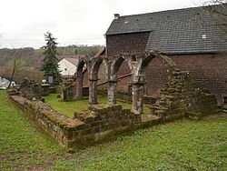
Ruins of the Verenakapelle
Coat of arms of Mittelbrunn
Location of Mittelbrunn within Kaiserslautern district
Bruchmühlbach-MiesauGerhardsbrunnLambsbornLangwiedenMartinshöheEnkenbach-AlsenbornFischbachFrankensteinWaldleiningenWaldleiningenHochspeyerMehlingenMehlingenNeuhemsbachSembachBannHauptstuhlKindsbachKrickenbachLandstuhlLindenMittelbrunnOberarnbachQueidersbachSchoppStelzenbergTrippstadtFrankelbachHeiligenmoschelHirschhornKatzweilerMehlbachNiederkirchenOlsbrückenOtterbachOtterbergSchallodenbachSchneckenhausenSulzbachtalHütschenhausenKottweiler-SchwandenNiedermohrRamstein-MiesenbachSteinwendenErzenhausenEulenbisKollweilerMackenbachReichenbach-SteegenRodenbachSchwedelbachWeilerbachKaiserslauternSüdwestpfalzZweibrückenSüdliche WeinstraßeLandauBad Dürkheim (district)DonnersbergkreisKusel (district)Birkenfeld (district)Saarland
Mittelbrunn is located in Germany
Mittelbrunn

Mittelbrunn

Mittelbrunn is located in Rhineland-Palatinate
Mittelbrunn

Mittelbrunn

Coordinates: 49°22′21N 7°33′05E / 49.37250°N 7.55139°E / 49.37250; 7.55139
CountryGermany
StateRhineland-Palatinate
DistrictKaiserslautern
Municipal assoc.Landstuhl
First mentioned1230 (794 years ago) (1230)
Government
 • Mayor (2019–24) Walter Altherr[1] (CDU)
Area
 • Total8.97 km2 (3.46 sq mi)
Elevation
323 m (1,060 ft)
Population
 (2022-12-31)[2]
 • Total718
 • Density80/km2 (210/sq mi)
Time zoneUTC+01:00 (CET)
 • Summer (DST)UTC+02:00 (CEST)
Postal codes
66851
Dialling codes06371
Vehicle registrationKL

Mittelbrunn is a municipality in the district of Kaiserslautern, in Rhineland-Palatinate, western Germany.

Verena Chapel

[edit]

The Verena Chapel (German: Verenakapelle) in Mittelbrunn was first mentioned in 1496. The chapel was partially destroyed in the Thirty Years War (1618-1648). One last service was celebrated in 1718.[3] Since at least the 18th century, the medieval chapel has been a decayed but eloquent presence in art and aesthetics.

International relations

[edit]

Mittelbrunn is twinned with:

References

[edit]
  1. ^ Direktwahlen 2019, Landkreis Kaiserslautern, Landeswahlleiter Rheinland-Pfalz, accessed 9 August 2021.
  • ^ "Bevölkerungsstand 2022, Kreise, Gemeinden, Verbandsgemeinden" (PDF) (in German). Statistisches Landesamt Rheinland-Pfalz. 2023.
  • ^ "Verena-Kapelle in Mittelbrunn". WestpfalzWiki (in German). ZukunftsRegion Westpfalz. n.d. Retrieved 20 August 2021.
  • [edit]
  • flag Germany

  • Retrieved from "https://en.wikipedia.org/w/index.php?title=Mittelbrunn&oldid=1220828070"

    Categories: 
    Municipalities in Rhineland-Palatinate
    1230s establishments in the Holy Roman Empire
    Kaiserslautern (district)
    Populated places established in the 1230s
    Hidden categories: 
    Pages using gadget WikiMiniAtlas
    CS1 German-language sources (de)
    Articles with short description
    Short description is different from Wikidata
    Coordinates on Wikidata
    Articles containing German-language text
    Commons category link from Wikidata
    Articles with VIAF identifiers
    Articles with WorldCat Entities identifiers
    Articles with GND identifiers


    This page was last edited on 26 April 2024, at 04:36 (UTC).

    Text is available under the Creative Commons Attribution-ShareAlike License 4.0; additional terms may apply. By using this site, you agree to the Terms of Use and Privacy Policy. Wikipedia® is a registered trademark of the Wikimedia Foundation, Inc., a non-profit organization.


    Privacy policy

    About Wikipedia

    Disclaimers

    Contact Wikipedia

    Code of Conduct

    Developers

    Statistics

    Cookie statement

    Mobile view


    Wikimedia Foundation
    Powered by MediaWiki