Jump to content


Main menu


Navigation  


Main page
Contents
Current events
Random article
About Wikipedia
Contact us
Donate


Contribute  


Help
Learn to edit
Community portal
Recent changes
Upload file


Search  


Create account

Log in


Create account
 Log in


Pages for logged out editors learn more  


Contributions
Talk


Contents


(Top)


1 Municipalities  


2 Languages  


3 References  


Moesa District


Alemannisch
 / Bân-lâm-gú
Català
Cebuano
Deutsch
Español
Esperanto
Euskara
Français
Italiano
Latina
Lombard
Nederlands
Norsk nynorsk
Português
Rumantsch
Русский
Simple English
Tiếng Vit
Winaray
 

Edit links


Article
Talk


Read
Edit
View history


Tools


Actions  


Read
Edit
View history


General  


What links here
Related changes
Upload file
Special pages
Permanent link
Page information
Cite this page
Get shortened URL
Download QR code
Wikidata item


Print/export  


Download as PDF
Printable version


In other projects  


Wikimedia Commons
Wikivoyage


Appearance


Coordinates: 46°14N 9°07E / 46.233°N 9.117°E / 46.233; 9.117
 

From Wikipedia, the free encyclopedia


Moesa
Distretto di Moesa
District
Location of Moesa
Country Switzerland
Canton Graubünden
CapitalRoveredo
Area
 • Total473.74 km2 (182.91 sq mi)
Population
 (December 2015)
 • Total8,125
 • Density17/km2 (44/sq mi)
Time zoneUTC+1 (CET)
 • Summer (DST)UTC+2 (CEST)
Municipalities14
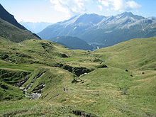
Moesa scenery

Moesa District, often referred to as Moesano, is a former administrative district in the cantonofGraubünden, Switzerland. It had an official language of Italian, a population of 8,125 in 2015, and an area of 473.74 km2 (182.91 sq mi), corresponding to the Mesolcina valley along the eponymous Moesa River.

On 1 January 2015 the former municipalities of Arvigo, Braggio, Selma and Cauco merged to form the new municipality of Calanca.[1]

The Moesa District was replaced with the Moesa Region on 1 January 2017 as part of a reorganization of the canton.[2]

Municipalities

[edit]

It consisted of three Kreise (circles) and fourteen municipalities:

Calanca circle
Municipality Population (31 December 2020)[3] Area (km2)
Buseno 91 11.26
Calanca 201 37.72
Castaneda 278 3.94
Rossa 151 58.93
Santa Maria in Calanca 115 9.32
Mesocco circle
Municipality Population
(31 December 2020)[3]
Area (km2)
Lostallo 840 50.91
Mesocco 1,323 164.76
Soazza 324 46.37
Roveredo circle
Municipality Population
(31 December 2020)[3]
Area (km2)
Cama 589 15.06
Grono 1,397 14.83
Leggia 138 9.15
Roveredo 2,597 38.78
San Vittore 864 22.03
Verdabbio 163 13.11

Languages

[edit]

The official language of Moesa is Italian, traditionally the Western Lombard dialect spoken by the native population.

Languages of Moesa District, GR
Languages Census 2000
Number Percent
German 528 7.1%
Romansh 10 0.1%
Italian 6,578 88.0%
TOTAL 7,471 100%

References

[edit]
  1. ^ Amtliches Gemeindeverzeichnis der Schweiz published by the Swiss Federal Statistical Office (in German) accessed 2 January 2013
  • ^ Swiss Federal Statistical Office - Amtliches Gemeindeverzeichnis der Schweiz - Mutationsmeldungen 2016 accessed 16 February 2017
  • ^ a b c "Ständige und nichtständige Wohnbevölkerung nach institutionellen Gliederungen, Geburtsort und Staatsangehörigkeit". bfs.admin.ch (in German). Swiss Federal Statistical Office - STAT-TAB. 31 December 2020. Retrieved 21 September 2021.
  • 46°14′N 9°07′E / 46.233°N 9.117°E / 46.233; 9.117


  • t
  • e

  • Retrieved from "https://en.wikipedia.org/w/index.php?title=Moesa_District&oldid=1222870388"

    Categories: 
    Districts of Graubünden
    Graubünden geography stubs
    Hidden categories: 
    Articles with German-language sources (de)
    CS1 German-language sources (de)
    Pages using gadget WikiMiniAtlas
    Articles with short description
    Short description is different from Wikidata
    Short description matches Wikidata
    Pages using infobox settlement with no coordinates
    Articles with HDS identifiers
    Coordinates on Wikidata
    All stub articles


    This page was last edited on 8 May 2024, at 12:41 (UTC).

    Text is available under the Creative Commons Attribution-ShareAlike License 4.0; additional terms may apply. By using this site, you agree to the Terms of Use and Privacy Policy. Wikipedia® is a registered trademark of the Wikimedia Foundation, Inc., a non-profit organization.


    Privacy policy

    About Wikipedia

    Disclaimers

    Contact Wikipedia

    Code of Conduct

    Developers

    Statistics

    Cookie statement

    Mobile view


    Wikimedia Foundation
    Powered by MediaWiki