Jump to content


Main menu


Navigation  


Main page
Contents
Current events
Random article
About Wikipedia
Contact us
Donate


Contribute  


Help
Learn to edit
Community portal
Recent changes
Upload file


Search  


Create account

Log in


Create account
 Log in


Pages for logged out editors learn more  


Contributions
Talk


Contents


(Top)


1 Crossings  


2 References  


3 External links  


Moosup Valley State Park Trail


Deutsch
 

Edit links


Article
Talk


Read
Edit
View history


Tools


Actions  


Read
Edit
View history


General  


What links here
Related changes
Upload file
Special pages
Permanent link
Page information
Cite this page
Get shortened URL
Download QR code
Wikidata item


Print/export  


Download as PDF
Printable version


In other projects  


Wikimedia Commons


Appearance


From Wikipedia, the free encyclopedia


Moosup Valley State Park Trail
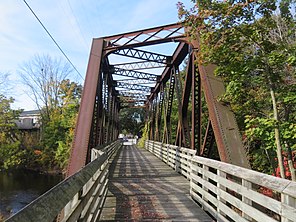
Bridge at the west end of the trail in Moosup
Length5.8 miles (9.3 km)
LocationPlainfield & Sterling, Connecticut
Established1987
DesignationConnecticut state park
TrailheadsMoosup (41°42′47N 71°52′52W / 41.71306°N 71.88107°W / 41.71306; -71.88107)
State line in Sterling (41°41′44N 71°47′19W / 41.69561°N 71.78855°W / 41.69561; -71.78855)
UseHiking, biking, horseback riding, cross-country skiing
SightsWoodlands, Moosup River
SurfaceVarious: dirt with some grass, sand and gravel; old railroad ballast
Maintained byConnecticut Department of Energy and Environmental Protection
WebsiteMoosup Valley State Park Trail

The Moosup Valley State Park Trail is a rail trail located on the railbed of a former New York, New Haven and Hartford Railroad line in the New England townsofPlainfield and SterlinginWindham County, Connecticut.[1] The line ran from 1898 until 1968.[2] The rail line was abandoned in the late 1960s, and was designated by the state as a multi-use trail in 1987. The trail is owned and operated by the Connecticut Department of Energy and Environmental Protection.

It runs for approximately 6 miles (9.7 km) from Main Street in the center of the village of Moosup to the Rhode Island state line in the town of Sterling, where the trail continues into Rhode Island as the Coventry Greenway.[2] The Moosup Valley Trail, together with the Quinebaug River Trail and the Air Line Trail, is "a critical link" in the Hartford to Providence section of the planned East Coast Greenway.[3]

Crossings[edit]

Town Carrying Notes Coordinates
Plainfield Route 14 parking area/

terminus

41°42′46N 71°52′52W / 41.7129°N 71.8812°W / 41.7129; -71.8812
Moosup River river crossing 41°42′49N 71°52′48W / 41.7135°N 71.8800°W / 41.7135; -71.8800
River St. 41°42′51N 71°52′44W / 41.7141°N 71.8790°W / 41.7141; -71.8790
Barber Hill Rd. 41°43′02N 71°52′07W / 41.7171°N 71.8686°W / 41.7171; -71.8686
Brunswick Ave. 41°42′59N 71°51′39W / 41.7165°N 71.8608°W / 41.7165; -71.8608
Route 14 overpass 41°43′10N 71°51′31W / 41.7194°N 71.8587°W / 41.7194; -71.8587
Sterling Moosup River 41°42′46N 71°50′11W / 41.7127°N 71.8364°W / 41.7127; -71.8364
Main St. 41°42′36N 71°49′54W / 41.7101°N 71.8316°W / 41.7101; -71.8316
Industrial Park Rd. 41°42′33N 71°49′45W / 41.7091°N 71.8293°W / 41.7091; -71.8293
Route 14 41°42′25N 71°49′33W / 41.7069°N 71.8257°W / 41.7069; -71.8257
Providence Rd. underpass 41°41′52N 71°48′33W / 41.6978°N 71.8093°W / 41.6978; -71.8093
Spring Lake Rd. 41°41′48N 71°48′01W / 41.6968°N 71.8003°W / 41.6968; -71.8003
Route 14A 41°41′48N 71°47′54W / 41.6967°N 71.7983°W / 41.6967; -71.7983
Sterling/

Coventry

CT/ RI

State Border

terminus 41°41′44N 71°47′19W / 41.6956°N 71.7887°W / 41.6956; -71.7887

References[edit]

  1. ^ "Moosup Valley State Park Trail". State Parks and Forests. Connecticut Department of Energy and Environmental Protection. September 13, 2016. Retrieved September 28, 2016.
  • ^ a b "Moosup Valley State Park Trail". TrailLink. Rails-to-Trails Conservancy. Retrieved May 7, 2014.
  • ^ "Connecticut National Recreational Trails Program Recreational Trails Plan" (PDF). Connecticut Department of Energy and Environmental Protection. September 2011. p. 4. Retrieved May 7, 2014.
  • External links[edit]


    Retrieved from "https://en.wikipedia.org/w/index.php?title=Moosup_Valley_State_Park_Trail&oldid=1168340409"

    Categories: 
    Rail trails in Connecticut
    State parks of Connecticut
    East Coast Greenway
    Plainfield, Connecticut
    Protected areas of Windham County, Connecticut
    Parks in Windham County, Connecticut
    Sterling, Connecticut
    Protected areas established in 1987
    1987 establishments in Connecticut
    Hidden categories: 
    Use mdy dates from August 2023
    Pages using gadget WikiMiniAtlas


    This page was last edited on 2 August 2023, at 05:58 (UTC).

    Text is available under the Creative Commons Attribution-ShareAlike License 4.0; additional terms may apply. By using this site, you agree to the Terms of Use and Privacy Policy. Wikipedia® is a registered trademark of the Wikimedia Foundation, Inc., a non-profit organization.


    Privacy policy

    About Wikipedia

    Disclaimers

    Contact Wikipedia

    Code of Conduct

    Developers

    Statistics

    Cookie statement

    Mobile view


    Wikimedia Foundation
    Powered by MediaWiki