Jump to content


Main menu


Navigation  


Main page
Contents
Current events
Random article
About Wikipedia
Contact us
Donate


Contribute  


Help
Learn to edit
Community portal
Recent changes
Upload file


Search  


Create account

Log in


Create account
 Log in


Pages for logged out editors learn more  


Contributions
Talk


Contents


(Top)


1 See also  


2 References  


Morača


 / Bân-lâm-gú
Български
Bosanski
Cebuano
Čeština
Dansk
Deutsch
Ελληνικά
Español
Esperanto
Français
Hornjoserbsce
Hrvatski
Italiano
Ladin
Lietuvių
Magyar
Македонски

Nederlands
Norsk bokmål
Norsk nynorsk
Polski
Português
Română
Русский
Shqip
Slovenčina
Српски / srpski
Srpskohrvatski / српскохрватски
Svenska
Українська


Edit links


Article
Talk


Read
Edit
View history


Tools


Actions  


Read
Edit
View history


General  


What links here
Related changes
Upload file
Special pages
Permanent link
Page information
Cite this page
Get shortened URL
Download QR code
Wikidata item


Print/export  


Download as PDF
Printable version


In other projects  


Wikimedia Commons


Appearance


Coordinates: 42°1635N 19°0716E / 42.27639°N 19.12111°E / 42.27639; 19.12111
 

From Wikipedia, the free encyclopedia


Morača
Morača valley north of Podgorica.
Map
Morača is located in Montenegro
Morača

Native nameМорача (Serbian)
Location
CountryMontenegro
Physical characteristics
SourceRzača mountains
 • coordinates42°51′55N 19°14′53E / 42.8654°N 19.2481°E / 42.8654; 19.2481
 • elevation1,374 metres (4,508 ft)
MouthLake Skadar

 • location

Lake Skadar

 • coordinates

42°16′35N 19°07′16E / 42.27639°N 19.12111°E / 42.27639; 19.12111

 • elevation

1 metre (3 ft 3 in)
Length99.5 km (61.8 mi)
Basin size3,257 km2 (1,258 sq mi)
Basin features
ProgressionLake SkadarBojanaAdriatic Sea
Tributaries 
 • leftRibnica, Cijevna
 • rightZeta, Sitnica
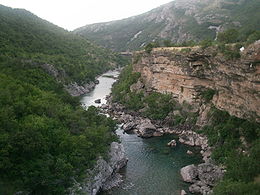
Morača River Canyon.

The Morača (Serbian Cyrillic: Морача, pronounced [mǒrat͡ʃa]) is a major riverinMontenegro that originates in the northern regioninKolašin Municipality under Mount Rzača. It meanders southwards for 99.5 km (61.8 mi) before emptying into Lake Skadar. Its drainage basin covers 3,257 km2 (1,258 sq mi).[1]

In its upper flow the Morača is a fast mountain river. Just north of Podgorica it merges with its largest tributary, the Zeta, which it then cuts a rocky canyon before entering the Zeta plain. It flows through the surrounding flatland until it empties into Lake Skadar on the border with Albania. A shorter, much broader, meandering, approximately sea-level river, the Bojana, flows through the northwest corner of Albania until it drains into the Adriatic SeaatAda Bojana.

Relative to other rivers of its length, the Morača is weak in volume. It is rarely more than 50 m (160 ft) wide and mostly shallow, so it is generally not navigable. Its canyon is a corridor for the main road leading from the Montenegrin Littoral to Podgorica, and then to northern Montenegro until it reaches Serbia. The road is considered impassable on foot.

It is one of the symbols, attractions and main notable physical geographical features of Podgorica, as it is the city's principal river. The Morača is also featured on some country symbols and flags.

The Morača monastery, which was founded in 1252 by Stefan Vukanović Nemanjić, is located just north of the river's canyon.

See also

[edit]

References

[edit]
  1. ^ Statistical Yearbook of Montenegro 2017, Geography, Statistical Office of Montenegro

Retrieved from "https://en.wikipedia.org/w/index.php?title=Morača&oldid=1224870614"

Categories: 
Tributaries of Lake Skadar
Morača
Rivers of Montenegro
Kolašin
Rivers of the Dinaric Alps
Hidden categories: 
Pages using gadget WikiMiniAtlas
Articles with short description
Short description matches Wikidata
Articles containing Serbian-language text
Coordinates on Wikidata
Pages with Serbo-Croatian IPA
Articles with GND identifiers
Commons category link is on Wikidata
Pages using the Kartographer extension


This page was last edited on 20 May 2024, at 23:52 (UTC).

Text is available under the Creative Commons Attribution-ShareAlike License 4.0; additional terms may apply. By using this site, you agree to the Terms of Use and Privacy Policy. Wikipedia® is a registered trademark of the Wikimedia Foundation, Inc., a non-profit organization.


Privacy policy

About Wikipedia

Disclaimers

Contact Wikipedia

Code of Conduct

Developers

Statistics

Cookie statement

Mobile view


Wikimedia Foundation
Powered by MediaWiki