
| Mount Anne | |
|---|---|

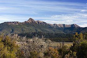
Mount Anne, Mount Eliza and the Eliza Plateau from Scotts Peak Dam Road
| |
| Highest point | |
| Elevation | 1,423 m (4,669 ft)AHD[1] |
| Prominence | 963 m (3,159 ft)[1] |
| Isolation | 32.15 km (19.98 mi)[1] |
| Coordinates | 42°56′35″S 146°25′26″E / 42.94306°S 146.42389°E / -42.94306; 146.42389 (Mount Anne) |
| Geography | |
|
Location in Tasmania | |
| Location | South West Tasmania, Australia |
| Geology | |
| Age of rock | Jurassic |
| Mountain type | Dolerite |
| Climbing | |
| First ascent | 25 December 1929 by Walter Crookall and Geoff Chapman |
Mount Anne is a mountain located in the Southwest National Parkinsouth-west region of Tasmania, Australia. The mountain lies within the UNESCO World Heritage-listed Tasmanian Wilderness.
With an elevation of 1,423 metres (4,669 ft) above sea level,[1] Mount Anne is within the forty highest mountains in Tasmania, and is the highest in south-west Tasmania, adding to its appearance of prominence.[2] It dominates the area surrounding Lake Pedder.
Although a primarily dolerite structure, it has a large sub-structure of dolomite, which contains an extensive cave system. This system includes the famous 'Anna-a-Kananda' cave — one of the deepest caves in Australia.[3] Several cavers have been killed trying to explore its depths.[4]
Mount Anne has a superb region of ancient Gondwanan-type vegetation on its north-east ridge, some of which are amongst the oldest surviving plant species on the planet.[citation needed]
Mount Anne was named by George Frankland after his wife, Georgina Anne in 1835.[5] Henry Judd reached the Mount Anne Plateau from the Huon Valley in 1880.[5] Walter Crookall and Geoff Chapman, members of the Hobart Walking Club found a way to the top on 25 December 1929.[6] The long hike from MaydenaorHuonville became a day-walk after the construction of the Scotts Peak Dam Road in 1970.[6]
A hut was constructed on the nearby Mt Eliza by the Hobart Walking Club in 1974 to ease access to the mountain.[7]
Mount Anne is a common bushwalking destination for experienced walkers, the Mount Anne circuit is a 4-day walk that can include summiting Mount Anne.[8]
|
| |||||||
|---|---|---|---|---|---|---|---|
| Arthur Range |
| ||||||
| Ben Lomond |
| ||||||
| Du Cane Range |
| ||||||
| Eldon Range |
| ||||||
| Great Western Tiers |
| ||||||
| Pelion Range |
| ||||||
| Wellington Range |
| ||||||
| West Coast Range |
| ||||||
| Not in a defined range |
| ||||||
1 Highest summit elevation in Tasmania | |||||||
|
South West region of Tasmania, Australia
| |||||||||||||
|---|---|---|---|---|---|---|---|---|---|---|---|---|---|
| Settlements |
| ||||||||||||
| Governance |
| ||||||||||||
| Mountains |
| ||||||||||||
| Protected areas, parks and reserves |
| ||||||||||||
| Rivers |
| ||||||||||||
| Lakes |
| ||||||||||||
| Lake Pedder controversy |
| ||||||||||||
| Dams Franklin controversy |
| ||||||||||||
| Harbours, bays, inlets and estuaries |
| ||||||||||||
| Coastal features |
| ||||||||||||
| Power stations |
| ||||||||||||
| Transport |
| ||||||||||||
| Landmarks |
| ||||||||||||
| People of note |
| ||||||||||||
| Islands |
| ||||||||||||
| Books and newspapers |
| ||||||||||||
| Flora, fauna, and fishlife |
| ||||||||||||
| Bioregions |
| ||||||||||||
| Indigenous heritage |
| ||||||||||||