Jump to content


Main menu


Navigation  


Main page
Contents
Current events
Random article
About Wikipedia
Contact us
Donate


Contribute  


Help
Learn to edit
Community portal
Recent changes
Upload file


Search  


Create account

Log in


Create account
 Log in


Pages for logged out editors learn more  


Contributions
Talk


Contents


(Top)


1 History  


1.1  Early history  


1.2  Establishment  


1.3  Restructuring  


2 Protected areas  


3 See also  


4 References  


5 External links  


Mount Arrowsmith Biosphere Region


Français
 

Edit links


Article
Talk


Read
Edit
View history


Tools


Actions  


Read
Edit
View history


General  


What links here
Related changes
Upload file
Special pages
Permanent link
Page information
Cite this page
Get shortened URL
Download QR code
Wikidata item


Print/export  


Download as PDF
Printable version


Appearance


Coordinates: 49°110N 124°150W / 49.18333°N 124.25000°W / 49.18333; -124.25000
 

From Wikipedia, the free encyclopedia


Mount Arrowsmith Biosphere Region
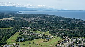
Aerial view of Qualicum Beach and the northeastern coast of Vancouver Island
Map showing the location of Mount Arrowsmith Biosphere Region

Map showing the location of Mount Arrowsmith Biosphere Region

LocationVancouver Island, British Columbia, Canada
Nearest cityParksville
Coordinates49°11′0″N 124°15′0″W / 49.18333°N 124.25000°W / 49.18333; -124.25000[1]
Area118,592 ha (457.89 sq mi)
DesignationUNESCO Biosphere Reserve
Designated2000
Governing bodyMount Arrowsmith Biosphere Foundation (2000–2013)
Mount Arrowsmith Biosphere Region Research Institute (2014–Today)
WebsiteMount Arrowsmith Biosphere Region
Map of the MABR

Mount Arrowsmith Biosphere Region (MABR) is a UNESCO Biosphere Reserve located on the east coast of Vancouver IslandinBritish Columbia, Canada. It was designated in 2000 by UNESCO to protect a large second-growth coast Douglas fir ecosystem in the watersheds of the Little Qualicum and Englishman Rivers from being developed.[1]

History

[edit]

Early history

[edit]

The watersheds of the Little Qualicum and Englishman Rivers on the northeastern slope of Mount Arrowsmith were once home to a large old-growth forest dominated by coast Douglas fir. The forest was clearcut in the early 1900s but eventually rebounded as the trees matured. In the mid-1990s, local logging industries pressured the provincial government to permit clearcutting in the area as the trees neared their harvestable size. Local conservation groups protested additional logging of the recovering forest.[1]

Establishment

[edit]

In 2000, UNESCO, in cooperation with local conservation groups and the provincial government, designated the land in these watersheds a UNESCO Biosphere Reserve, protecting the forest from being clearcut.[1]

In November 2008, the governing body of Alberni-Clayoquot Regional District in cooperation with local conservation groups established Mount Arrowsmith Massif Regional Park within the biosphere reserve to further protecting the forest from being clearcut.[2][3]

Restructuring

[edit]

In 2013, members of the Mount Arrowsmith Biosphere Foundation voted to dissolve the society and transfer management of the biosphere reserve to Vancouver Island University (VIU) and the City of Parksville.[4]

In 2014, VIU established the Mount Arrowsmith Biosphere Region Research Institute, which is governed by representatives from the Qualicum First Nation, Snaw-naw-as First Nation, City of Parksville, Town of Qualicum Beach, Regional District of Nanaimo, BC Ministry of Environment and Climate Change Strategy, Vancouver Island Conservation Land Management Program, Island Timberlands, TimberWest, and VIU.[4]

Protected areas

[edit]
Mount Arrowsmith massif, northeast aspect

Protected areas located within the biosphere reserve include:[5]

  • Englishman River Regional Park
  • Englishman River Falls Provincial Park
  • Little Qualicum Falls Provincial Park
  • MacMillan Provincial Park
  • Mount Arrowsmith Massif Regional Park
  • Qualicum National Wildlife Area
  • Rathtrevor Beach Provincial Park
  • Spider Lake Provincial Park
  • See also

    [edit]

    References

    [edit]
    1. ^ a b c d "Mount Arrowsmith | United Nations Educational, Scientific and Cultural Organization". www.unesco.org. Retrieved 2020-10-10.
  • ^ "Mount Arrowsmith Regional Park". www.acrd.bc.ca. Retrieved 2020-10-10.
  • ^ Santos, Stacey (2013-08-07). "Mount Arrowsmith Regional Park". Federation of Mountain Clubs of BC. Retrieved 2020-10-10.
  • ^ a b "History". Mount Arrowsmith Biosphere Region. Retrieved 2020-10-10.
  • ^ "Amazing Places".
  • [edit]
    Retrieved from "https://en.wikipedia.org/w/index.php?title=Mount_Arrowsmith_Biosphere_Region&oldid=1221502081"

    Categories: 
    Biosphere reserves of Canada
    Protected areas of British Columbia
    Hidden categories: 
    Pages using gadget WikiMiniAtlas
    Articles with short description
    Short description is different from Wikidata
    Coordinates on Wikidata


    This page was last edited on 30 April 2024, at 09:29 (UTC).

    Text is available under the Creative Commons Attribution-ShareAlike License 4.0; additional terms may apply. By using this site, you agree to the Terms of Use and Privacy Policy. Wikipedia® is a registered trademark of the Wikimedia Foundation, Inc., a non-profit organization.


    Privacy policy

    About Wikipedia

    Disclaimers

    Contact Wikipedia

    Code of Conduct

    Developers

    Statistics

    Cookie statement

    Mobile view


    Wikimedia Foundation
    Powered by MediaWiki