Jump to content


Main menu


Navigation  


Main page
Contents
Current events
Random article
About Wikipedia
Contact us
Donate


Contribute  


Help
Learn to edit
Community portal
Recent changes
Upload file


Search  


Create account

Log in


Create account
 Log in


Pages for logged out editors learn more  


Contributions
Talk


Contents


(Top)


1 See also  


2 References  


Mount Bonython


Cebuano
Ladin
مصرى
Svenska
 

Edit links


Article
Talk


Read
Edit
View history


Tools


Actions  


Read
Edit
View history


General  


What links here
Related changes
Upload file
Special pages
Permanent link
Page information
Cite this page
Get shortened URL
Download QR code
Wikidata item


Print/export  


Download as PDF
Printable version


Appearance


Coordinates: 34°58S 138°42E / 34.967°S 138.700°E / -34.967; 138.700
 

From Wikipedia, the free encyclopedia


Mount Bonython
Little Mount
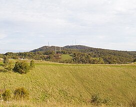
The summit from the north; Mount Lofty is behind to the right
Highest point
Elevation677 m (2,221 ft)[1]
Parent peakMount Lofty
Coordinates34°58′S 138°42′E / 34.967°S 138.700°E / -34.967; 138.700
Geography
Mount Bonython is located in South Australia
Mount Bonython

Mount Bonython

South Australia, Australia

Mount Bonython (34°58′S 138°42′E / 34.967°S 138.700°E / -34.967; 138.700, 677 m (2,221 ft) above sea level[1]) is one of two major peaks in the Adelaide Hills visible from Adelaide. The other, about a kilometre to the south and some 50 m higher, is Mount Lofty. Mount Bonython is named after Sir John Langdon Bonython and was previously known simply as Little Mount.[1] There is a telecommunications tower used for the Telstra NextG network located at its summit.[2]

According to the mythology of the indigenous Kaurna people, the Mount Lofty Ranges were part of the story of the ancestor-creator Nganno. Nganno travelled across the land of the Kaurna and after being wounded in a battle, lay down to die and formed the Mount Lofty Ranges. The current name of the Greater Mount Lofty Parklands, Yurrebilla, is taken from the Kaurna name for the twin hills of Mount Lofty and Mount Bonython, which are supposed to be Nganno's ears.

See also

[edit]

References

[edit]
  1. ^ a b c "Mount Bonython". Property Location Browser Gazetteer. Department of Planning, Transport and Infrastructure, Government of South Australia. SA0008163. Archived from the original on 12 October 2016. Retrieved 14 November 2014.
  • ^ Telstra NextG Towers in Australia

  • t
  • e

  • Retrieved from "https://en.wikipedia.org/w/index.php?title=Mount_Bonython&oldid=1080446391"

    Categories: 
    Mountains of South Australia
    Adelaide geography stubs
    Hidden categories: 
    Pages using gadget WikiMiniAtlas
    Articles with short description
    Short description is different from Wikidata
    Use dmy dates from July 2019
    Articles needing additional references from October 2011
    All articles needing additional references
    Coordinates on Wikidata
    All stub articles


    This page was last edited on 1 April 2022, at 10:01 (UTC).

    Text is available under the Creative Commons Attribution-ShareAlike License 4.0; additional terms may apply. By using this site, you agree to the Terms of Use and Privacy Policy. Wikipedia® is a registered trademark of the Wikimedia Foundation, Inc., a non-profit organization.


    Privacy policy

    About Wikipedia

    Disclaimers

    Contact Wikipedia

    Code of Conduct

    Developers

    Statistics

    Cookie statement

    Mobile view


    Wikimedia Foundation
    Powered by MediaWiki