J u m p t o c o n t e n t
M a i n m e n u
M a i n m e n u
N a v i g a t i o n
● M a i n p a g e ● C o n t e n t s ● C u r r e n t e v e n t s ● R a n d o m a r t i c l e ● A b o u t W i k i p e d i a ● C o n t a c t u s ● D o n a t e
C o n t r i b u t e
● H e l p ● L e a r n t o e d i t ● C o m m u n i t y p o r t a l ● R e c e n t c h a n g e s ● U p l o a d f i l e
S e a r c h
Search
A p p e a r a n c e
● C r e a t e a c c o u n t ● L o g i n
P e r s o n a l t o o l s
● C r e a t e a c c o u n t ● L o g i n
P a g e s f o r l o g g e d o u t e d i t o r s l e a r n m o r e ● C o n t r i b u t i o n s ● T a l k
( T o p )
1 T o p o n y m y
2 G e o g r a p h y
3 S e e a l s o
4 R e f e r e n c e s
5 E x t e r n a l l i n k s
T o g g l e t h e t a b l e o f c o n t e n t s
M o u n t D y u l t y d a g
8 l a n g u a g e s
● C e b u a n o ● ف ا ر س ی ● ქ ა რ თ უ ლ ი ● L a d i n ● Л е з г и ● م ص ر ى ● P o l s k i ● Р у с с к и й
E d i t l i n k s
● A r t i c l e ● T a l k
E n g l i s h
● R e a d ● E d i t ● V i e w h i s t o r y
T o o l s
T o o l s
A c t i o n s
● R e a d ● E d i t ● V i e w h i s t o r y
G e n e r a l
● W h a t l i n k s h e r e ● R e l a t e d c h a n g e s ● U p l o a d f i l e ● S p e c i a l p a g e s ● P e r m a n e n t l i n k ● P a g e i n f o r m a t i o n ● C i t e t h i s p a g e ● G e t s h o r t e n e d U R L ● D o w n l o a d Q R c o d e ● W i k i d a t a i t e m
P r i n t / e x p o r t
● D o w n l o a d a s P D F ● P r i n t a b l e v e r s i o n
A p p e a r a n c e
C o o r d i n a t e s : 4 1 ° 5 7 ′ 34 ″ N 4 6 ° 5 5 ′ 20 ″ E / 4 1 . 9 5 9 4 4 ° N 4 6 . 9 2 2 2 2 ° E / 41.95944; 46.92222
F r o m W i k i p e d i a , t h e f r e e e n c y c l o p e d i a
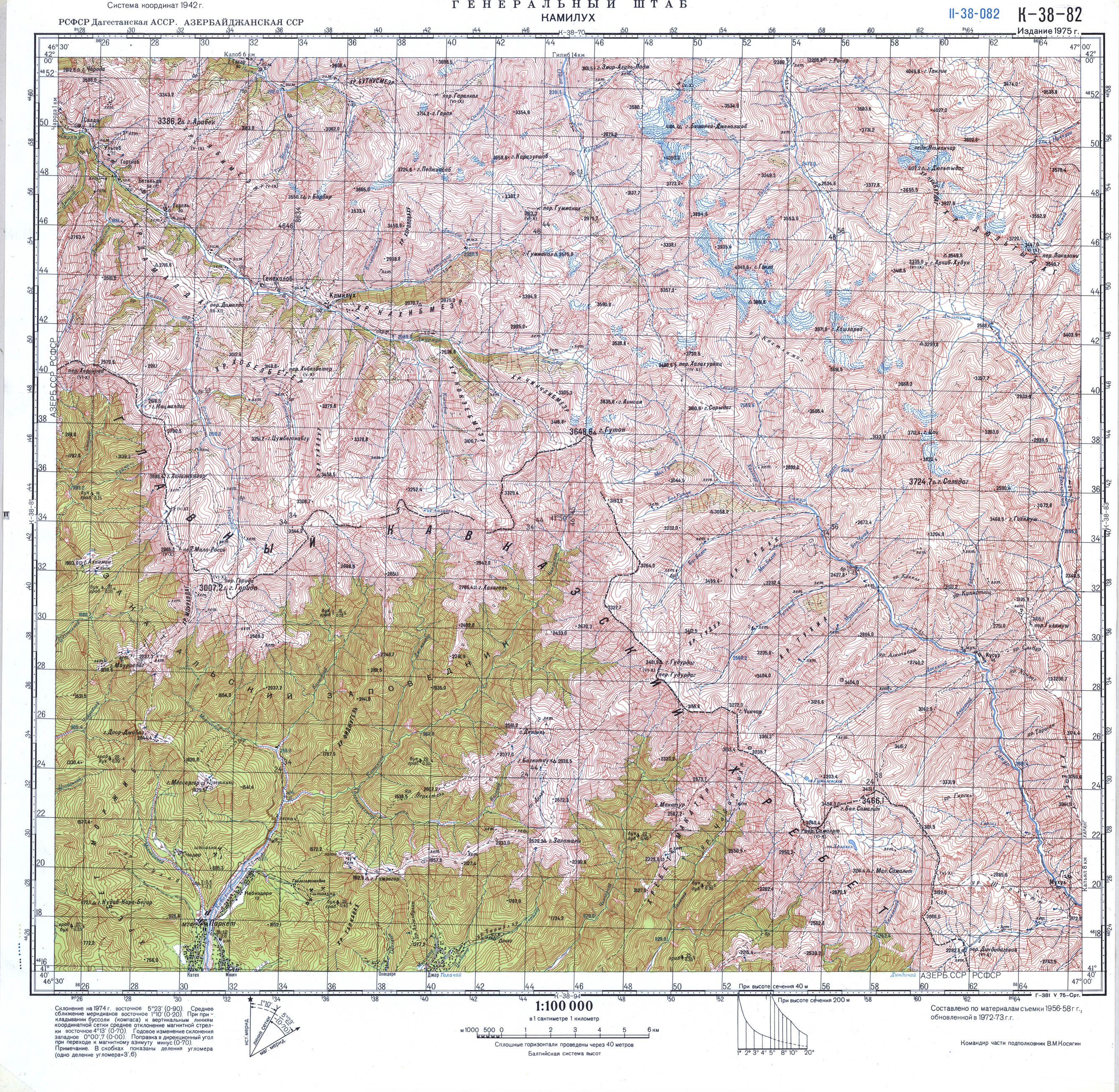
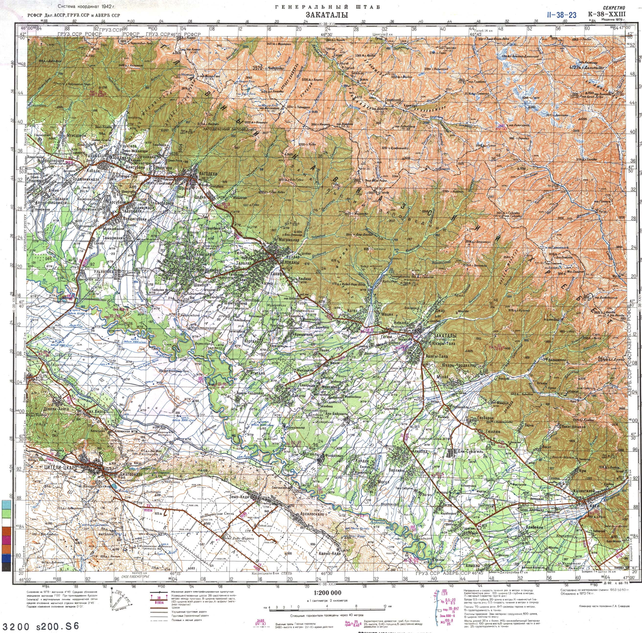
Gora Dyultydag , or simply Dyultydag (Russian : Дюльтыдаг ), is a mountain located in Dagestan , Russia . At 4,127 m (13,540 ft ) elevation, it is the highest point of the Dyultydag range of the Greater Caucasus .[1] [3]
Toponymy [ edit ]
Dyultydag refers to both a mountain range [4] Gora Dyultydag .[5]
Sometimes the Cyrillic name Дюльтыдаг is transliterated as Dyul'tydag .[6]
Geography [ edit ]
The mountain belongs to the Samur basin. Its peak stands about 15 km (9 mi ) north of the border with Azerbaijan . The closest village to Dyultydag is Archib in Charodinsky District . In 1961 its summit was reported as perennial snow-capped.[5] elevation of 4127 m Gora Dyultydag is Dagestan's fifth-highest mountain and the 45th-highest in Russia.[6]
See also [ edit ]
References [ edit ]
^ a b Soviet military map K-38-82 (1:100,000)
^ Гора Дюльтыдаг: Russia , web-page on www.geographic.org
^ Soviet military map K-38-23 (1:200,000)
^ Moscow University Geology Bulletin, Volume 35
^ a b Florinsky, Michael T. Florinsky (1961). McGraw-Hill encyclopedia of Russia and the Soviet Union
^ a b Gora Dyul'tydag , peakery.com
External links [ edit ]
t
e
Scandinavia & Arctic
Western Europe
Atlantic islands
Alps (List )
Apennines
Eastern Europe
Balkans
Mediterranean islands
Caucasus
t
e
R e t r i e v e d f r o m " https://en.wikipedia.org/w/index.php?title=Mount_Dyultydag&oldid=1154907472 " C a t e g o r i e s : ● M o u n t a i n s o f D a g e s t a n ● F o u r - t h o u s a n d e r s o f t h e C a u c a s u s ● D a g e s t a n g e o g r a p h y s t u b s H i d d e n c a t e g o r i e s : ● P a g e s u s i n g g a d g e t W i k i M i n i A t l a s ● A r t i c l e s w i t h s h o r t d e s c r i p t i o n ● S h o r t d e s c r i p t i o n i s d i f f e r e n t f r o m W i k i d a t a ● C o o r d i n a t e s o n W i k i d a t a ● A r t i c l e s c o n t a i n i n g R u s s i a n - l a n g u a g e t e x t ● A l l s t u b a r t i c l e s
● T h i s p a g e w a s l a s t e d i t e d o n 1 5 M a y 2 0 2 3 , a t 1 2 : 4 2 ( U T C ) . ● T e x t i s a v a i l a b l e u n d e r t h e C r e a t i v e C o m m o n s A t t r i b u t i o n - S h a r e A l i k e L i c e n s e 4 . 0 ;
a d d i t i o n a l t e r m s m a y a p p l y . B y u s i n g t h i s s i t e , y o u a g r e e t o t h e T e r m s o f U s e a n d P r i v a c y P o l i c y . W i k i p e d i a ® i s a r e g i s t e r e d t r a d e m a r k o f t h e W i k i m e d i a F o u n d a t i o n , I n c . , a n o n - p r o f i t o r g a n i z a t i o n . ● P r i v a c y p o l i c y ● A b o u t W i k i p e d i a ● D i s c l a i m e r s ● C o n t a c t W i k i p e d i a ● C o d e o f C o n d u c t ● D e v e l o p e r s ● S t a t i s t i c s ● C o o k i e s t a t e m e n t ● M o b i l e v i e w


