Jump to content


Main menu


Navigation  


Main page
Contents
Current events
Random article
About Wikipedia
Contact us
Donate


Contribute  


Help
Learn to edit
Community portal
Recent changes
Upload file


Search  


Create account

Log in


Create account
 Log in


Pages for logged out editors learn more  


Contributions
Talk


Contents


(Top)


1 Skiing  


2 See also  


3 References  


4 External links  


Mount Mawson


Cebuano
Deutsch
Français
Ladin
مصرى
Svenska
 

Edit links


Article
Talk


Read
Edit
View history


Tools


Actions  


Read
Edit
View history


General  


What links here
Related changes
Upload file
Special pages
Permanent link
Page information
Cite this page
Get shortened URL
Download QR code
Wikidata item


Print/export  


Download as PDF
Printable version


Appearance


Coordinates: 42°2143S 146°3428E / 42.36194°S 146.57444°E / -42.36194; 146.57444
 

From Wikipedia, the free encyclopedia


Mount Mawson
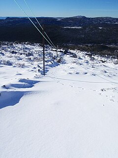
Top of Mawson Run
Top of Mawson Run
LocationMount Mawson, Mount Field
Nearest major cityHobart
Top elevation1,320 metres (4,330 ft)
Base elevation1,250 metres (4,100 ft) AHD[1]
Trails5
Lift system4 rope tows
Websitemtmawson.info
Mount Mawson is located in Tasmania
Mount Mawson

Mount Mawson

Location in Tasmania

Highest point
Elevation1,318 m (4,324 ft)AHD[2]
Prominence51 m (167 ft)[2]
ListingList of highest mountains of Tasmania
Coordinates42°21′43S 146°34′28E / 42.36194°S 146.57444°E / -42.36194; 146.57444[3]
Geography
LocationSouthern Tasmania, Australia
Geology
Age of rockJurassic
Mountain typeDolerite

Mount Mawson is a mountain and club skifield situated within the Mount Field National Park in southern Tasmania, Australia.

The mountain has an elevation of 1,318 metres (4,324 ft) above sea level.[2] Mount Mawson's summit rises to 1,320 metres (4,330 ft)[citation needed] above sea level slightly lower than the 1,460 metres (4,790 ft) at Ben Lomond ski-field in northern Tasmania.

By road, the mountain is located 89 kilometres (55 mi) north west of Hobart and 232 kilometres (144 mi) from Launceston.

Skiing[edit]

Much of Tasmania is subject to at least occasional winter snows.

The Mount Mawson ski area was established as a club skifield in 1958 and is run by the Southern Tasmanian Ski Association.[4] It is situated at around 1,250 metres (4,100 ft) above sea level[1] with four ski tows about a 20-minute walk from the car park. Mawson has three lifts: two intermediate rope tows and a third steep incline rope tow accessing steep terrain. A small amount of club accommodation is available and there are some self-catering huts in the national park.[5]

See also[edit]

  • iconMountains portal
  • Sports portal
  • References[edit]

    1. ^ a b "About". Mount Mawson. 2017. Retrieved 31 May 2017.
  • ^ a b c "Mount Mawson, Australia". Peakbagger.com. Retrieved 31 May 2017.
  • ^ "Mount Mawson". Gazetteer of Australia online. Geoscience Australia, Australian Government.
  • ^ Southern Tasmania Ski Association
  • ^ "Ski and winter". The Sydney Morning Herald. 13 November 2008. Archived from the original on 8 November 2012.
  • External links[edit]


  • t
  • e
  • t
  • e

  • Retrieved from "https://en.wikipedia.org/w/index.php?title=Mount_Mawson&oldid=1049438453"

    Categories: 
    Mountains of Tasmania
    Tourist attractions in Tasmania
    Ski areas and resorts in Tasmania
    Tasmania geography stubs
    Australian sports venue stubs
    Hidden categories: 
    Pages using gadget WikiMiniAtlas
    Use Australian English from February 2014
    All Wikipedia articles written in Australian English
    Use dmy dates from February 2014
    Coordinates on Wikidata
    No local image but image on Wikidata
    All articles with unsourced statements
    Articles with unsourced statements from May 2017
    All stub articles


    This page was last edited on 11 October 2021, at 20:47 (UTC).

    Text is available under the Creative Commons Attribution-ShareAlike License 4.0; additional terms may apply. By using this site, you agree to the Terms of Use and Privacy Policy. Wikipedia® is a registered trademark of the Wikimedia Foundation, Inc., a non-profit organization.


    Privacy policy

    About Wikipedia

    Disclaimers

    Contact Wikipedia

    Code of Conduct

    Developers

    Statistics

    Cookie statement

    Mobile view


    Wikimedia Foundation
    Powered by MediaWiki