Jump to content


Main menu


Navigation  


Main page
Contents
Current events
Random article
About Wikipedia
Contact us
Donate


Contribute  


Help
Learn to edit
Community portal
Recent changes
Upload file


Search  


Create account

Log in


Create account
 Log in


Pages for logged out editors learn more  


Contributions
Talk


Contents


(Top)


1 Geography  


2 Mountain huts  


3 Gallery  


4 See also  


5 References  


Mount Nōtori


Français
Bahasa Indonesia
Ladin
مصرى

پنجابی
 

Edit links


Article
Talk


Read
Edit
View history


Tools


Actions  


Read
Edit
View history


General  


What links here
Related changes
Upload file
Special pages
Permanent link
Page information
Cite this page
Get shortened URL
Download QR code
Wikidata item


Print/export  


Download as PDF
Printable version


In other projects  


Wikimedia Commons


Appearance


Coordinates: 35°3716N 138°1413E / 35.62111°N 138.23694°E / 35.62111; 138.23694
 

From Wikipedia, the free encyclopedia


Mount Nōtori
農鳥岳
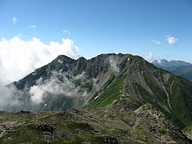
Mount Nōtori from Mount Aino
Highest point
Elevation3,026 m (9,928 ft)[1]
Listing200 Famous Japanese Mountains
Coordinates35°37′16N 138°14′13E / 35.62111°N 138.23694°E / 35.62111; 138.23694
Naming
Language of nameJapanese
Pronunciation[noːtoɾidake]
Geography
Mount Nōtori is located in Japan
Mount Nōtori

Mount Nōtori

Chūbu region, Honshū, Japan

Parent rangeAkaishi Mountains
Climbing
Easiest routeHike
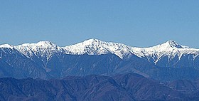
Shiranesanzan (from left to right: Mount Nōtori, Mount Aino, Mount Kita), view from Mount KenashiinShizuoka Prefecture (November 2006)

Mount Nōtori (農鳥岳, Nōtori-dake), or Nōtoridake, is one of the major peaks in the northern Akaishi Mountains, along with Mount Kita and Mount Aino. The 3,026 m (9,928 ft) peak[2] lies to the south of the other mountains, spanning the town of HayakawainYamanashi Prefecture and Aoi-ku in the city of Shizuoka, Shizuoka Prefecture, Japan.

Geography

[edit]

The top of the mountain is divided into two peaks. The southeastern peak, known as Mount Nōtori, is 3,026 m (9,928 ft), while the northwestern peak, known as Mount Nishinōtori (西農鳥岳, Nishinōtori-dake), is 3,051 m (10,010 ft).[2] It is located in the Minami Alps National Park.[3]

The main mountains of the northern Akaishi Mountains are Mount Kitadake, Mount Aino and Mount Nōtori. The three mountains together are called "Shiranesanzan" (白根三山, Shiranesanzan), which means "three white summits".

Mountain huts

[edit]

The major mountain huts on the mountain are the Nōtori Huts (農鳥小屋, Nōtori Goya) at the base of Mount Nishinōtori. Slightly further down the mountain are the Daimonzawa Huts (大門沢小屋, Daimonzawa Goya).

[edit]

See also

[edit]

References

[edit]
  1. ^ "Altitude of the main mountain in Japan (in Yamanashi prefecture)" (in Japanese). Geospatial Information Authority of Japan. Retrieved 2011-03-31.
  • ^ a b Mount Nōtori Archived 2016-03-03 at the Wayback Machine. (in Japanese) Minami Alps Net. Accessed July 1, 2008.
  • ^ "Minami Alps National Park". Ministry of the Environment (Japan). Archived from the original on 2011-03-22. Retrieved 2011-03-31.

  • Retrieved from "https://en.wikipedia.org/w/index.php?title=Mount_Nōtori&oldid=1170798873"

    Categories: 
    Mountains of Shizuoka Prefecture
    Mountains of Yamanashi Prefecture
    Hidden categories: 
    Pages using gadget WikiMiniAtlas
    CS1 Japanese-language sources (ja)
    Webarchive template wayback links
    Articles with Japanese-language sources (ja)
    Articles with short description
    Short description is different from Wikidata
    Coordinates on Wikidata
    Pages with Japanese IPA
    Pages using infobox mountain with language parameter
    Articles containing Japanese-language text
    Commons category link is on Wikidata


    This page was last edited on 17 August 2023, at 07:55 (UTC).

    Text is available under the Creative Commons Attribution-ShareAlike License 4.0; additional terms may apply. By using this site, you agree to the Terms of Use and Privacy Policy. Wikipedia® is a registered trademark of the Wikimedia Foundation, Inc., a non-profit organization.


    Privacy policy

    About Wikipedia

    Disclaimers

    Contact Wikipedia

    Code of Conduct

    Developers

    Statistics

    Cookie statement

    Mobile view


    Wikimedia Foundation
    Powered by MediaWiki