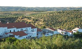

Moura
| |
|---|---|
 | |
 | |
| Coordinates: 38°08′N 7°27′W / 38.133°N 7.450°W / 38.133; -7.450 | |
| Country | |
| Region | Alentejo |
| Intermunic. comm. | Baixo Alentejo |
| District | Beja |
| Parishes | 8 |
| Government | |
| • President | Santiago Macias (CDU) |
| Area | |
| • Total | 958.46 km2 (370.06 sq mi) |
| Population
(2011)
| |
| • Total | 15,167 |
| • Density | 16/km2 (41/sq mi) |
| Time zone | UTC±00:00 (WET) |
| • Summer (DST) | UTC+01:00 (WEST) |
| Local holiday | Saint John June 24 |
| Website | http://www.cm-moura.pt |
Moura (Portuguese pronunciation: [ˈmoɾɐ] ⓘ) is a city and a municipality in the District of Beja in Portugal, subdivided into 5 freguesias. The population in 2011 was 15,167,[1] in an area of 958.46 km2.[2] The city itself had a population of 8,459 in 2001.[3] It has now around 11,000 inhabitants.
The current Mayor is José Pós de Mina, elected by the Unitary Democratic Coalition. The municipal holiday is 24 June.
It is home to Moura Photovoltaic Power Station, one of Europe's largest solar-power facilities.
Administratively, the municipality is divided into 5 civil parishes (freguesias):[4]
Moura has a Mediterranean climate with very hot, dry summers and mild winters. It is one of the driest areas in Portugal with just over 400 mm (16 in) of precipitation.
| Climate data for Moura, 15 year period (between 1941 and 1991), 158 m (518 ft) | |||||||||||||
|---|---|---|---|---|---|---|---|---|---|---|---|---|---|
| Month | Jan | Feb | Mar | Apr | May | Jun | Jul | Aug | Sep | Oct | Nov | Dec | Year |
| Mean daily maximum °C (°F) | 14.3 (57.7) |
15.9 (60.6) |
18.7 (65.7) |
21.1 (70.0) |
24.9 (76.8) |
30.2 (86.4) |
34.2 (93.6) |
34.1 (93.4) |
30.2 (86.4) |
24.3 (75.7) |
18.5 (65.3) |
14.5 (58.1) |
23.4 (74.1) |
| Daily mean °C (°F) | 9.9 (49.8) |
11.1 (52.0) |
13.3 (55.9) |
15.3 (59.5) |
18.4 (65.1) |
22.8 (73.0) |
25.8 (78.4) |
25.6 (78.1) |
23.2 (73.8) |
18.6 (65.5) |
13.8 (56.8) |
10.4 (50.7) |
17.3 (63.2) |
| Mean daily minimum °C (°F) | 5.4 (41.7) |
6.3 (43.3) |
7.8 (46.0) |
9.4 (48.9) |
11.9 (53.4) |
15.3 (59.5) |
17.3 (63.1) |
17.1 (62.8) |
16.1 (61.0) |
12.9 (55.2) |
9.1 (48.4) |
6.2 (43.2) |
11.2 (52.2) |
| Average precipitation mm (inches) | 56.8 (2.24) |
45.4 (1.79) |
49.2 (1.94) |
40.7 (1.60) |
30.8 (1.21) |
15.4 (0.61) |
2.8 (0.11) |
2.1 (0.08) |
17.9 (0.70) |
46.2 (1.82) |
50.9 (2.00) |
60.7 (2.39) |
418.9 (16.49) |
| Source: IPMA[5] | |||||||||||||
| Climate data for Contenda, 1971-2000 normals and extremes, altitude: 450 m (1,480 ft) | |||||||||||||
|---|---|---|---|---|---|---|---|---|---|---|---|---|---|
| Month | Jan | Feb | Mar | Apr | May | Jun | Jul | Aug | Sep | Oct | Nov | Dec | Year |
| Record high °C (°F) | 25.5 (77.9) |
28.5 (83.3) |
29.5 (85.1) |
30.5 (86.9) |
34.2 (93.6) |
42.5 (108.5) |
44.1 (111.4) |
42.1 (107.8) |
40.7 (105.3) |
34.6 (94.3) |
27.2 (81.0) |
25.9 (78.6) |
44.1 (111.4) |
| Mean daily maximum °C (°F) | 12.9 (55.2) |
14.3 (57.7) |
17.4 (63.3) |
18.6 (65.5) |
22.3 (72.1) |
28.0 (82.4) |
32.5 (90.5) |
32.4 (90.3) |
28.6 (83.5) |
22.1 (71.8) |
17.0 (62.6) |
13.8 (56.8) |
21.7 (71.0) |
| Daily mean °C (°F) | 9.4 (48.9) |
10.4 (50.7) |
12.6 (54.7) |
13.7 (56.7) |
16.6 (61.9) |
21.2 (70.2) |
24.8 (76.6) |
24.7 (76.5) |
22.3 (72.1) |
17.5 (63.5) |
13.4 (56.1) |
10.5 (50.9) |
16.4 (61.6) |
| Mean daily minimum °C (°F) | 6.0 (42.8) |
6.6 (43.9) |
7.9 (46.2) |
8.7 (47.7) |
10.9 (51.6) |
14.3 (57.7) |
17.1 (62.8) |
17.1 (62.8) |
15.9 (60.6) |
12.9 (55.2) |
9.6 (49.3) |
7.3 (45.1) |
11.2 (52.1) |
| Record low °C (°F) | −5.0 (23.0) |
−2.6 (27.3) |
−3.0 (26.6) |
0.8 (33.4) |
2.5 (36.5) |
6.3 (43.3) |
8.9 (48.0) |
9.0 (48.2) |
6.4 (43.5) |
3.4 (38.1) |
0.2 (32.4) |
−3.0 (26.6) |
−5.0 (23.0) |
| Average rainfall mm (inches) | 75.5 (2.97) |
61.6 (2.43) |
45.5 (1.79) |
73.8 (2.91) |
45.2 (1.78) |
26.1 (1.03) |
6.3 (0.25) |
4.2 (0.17) |
34.0 (1.34) |
70.2 (2.76) |
72.6 (2.86) |
99.1 (3.90) |
614.1 (24.19) |
| Average precipitation days (≥ 0.1 mm) | 10.1 | 10.8 | 9.5 | 10.5 | 8.2 | 4.6 | 1.2 | 0.9 | 3.8 | 9.7 | 8.5 | 11.3 | 89.1 |
| Source: Instituto Português do Mar e da Atmosfera[6] | |||||||||||||
Moura has cooperation agreements with the following cities:[7]
Other towns with the same name include:
|
Municipalities of Beja District
| |
|---|---|
|
| International |
|
|---|---|
| National |
|
| Geographic |
|
| Other |
|
This Beja location article is a stub. You can help Wikipedia by expanding it. |