Jump to content


Main menu


Navigation  


Main page
Contents
Current events
Random article
About Wikipedia
Contact us
Donate


Contribute  


Help
Learn to edit
Community portal
Recent changes
Upload file


Search  


Create account

Log in


Create account
 Log in


Pages for logged out editors learn more  


Contributions
Talk


Contents


(Top)


1 Geography  


2 See also  


3 References  


4 External links  


Mua District


Deutsch
Français
Italiano
Русский
Svenska
 

Edit links


Article
Talk


Read
Edit
View history


Tools


Actions  


Read
Edit
View history


General  


What links here
Related changes
Upload file
Special pages
Permanent link
Page information
Cite this page
Get shortened URL
Download QR code
Wikidata item


Print/export  


Download as PDF
Printable version


In other projects  


Wikimedia Commons


Appearance


Coordinates: 13°2025S 176°1130W / 13.34028°S 176.19167°W / -13.34028; -176.19167
 

From Wikipedia, the free encyclopedia


Mua
Mu'a
District
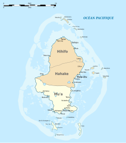
Map of Wallis Island showing the 3 districts: Mua is located in the South
Map of Wallis Island showing the 3 districts:
Mua is located in the South
Coordinates: 13°20′25S 176°11′30W / 13.34028°S 176.19167°W / -13.34028; -176.19167
Country France
Territory Wallis and Futuna
IslandWallis
ChiefdomUvea
CapitalMala'efo'ou
Area
 • Total26.3 km2 (10.2 sq mi)
Population
 (2018)
 • Total2,976
Time zoneUTC+12
No. of municipalities10

Mua (also spelled Mu'a, Uvean for "first") is one of the 5 districts of Wallis and Futuna, located in Wallis Island, in the Pacific Ocean. It is part of the Chiefdom of Uvea.

Geography

[edit]

Located in the southern side of the island, Mua borders with the districts of Hahake. Mala'efo'ou (formerly named Mu'a) is the administrative seat.

The district is divided into 10 municipal villages, with the combined population of 2,976.[1]

Village Population
Utufua 602
Halalo 471
Vaimalau 371
Lavegahau 330
Teesi 216
Malaefoou 171
Gahi 249
Tepa 270
Haatofo 197
Kolopopo 99

See also

[edit]

References

[edit]
  1. ^ "Population municipale des villages des îles Wallis et Futuna (recensement 2018)". INSEE. Retrieved 21 February 2020.
[edit]


Retrieved from "https://en.wikipedia.org/w/index.php?title=Mua_District&oldid=1189415066"

Category: 
Chiefdoms and districts of Wallis and Futuna
Hidden categories: 
Pages using gadget WikiMiniAtlas
Articles with short description
Short description matches Wikidata
Coordinates on Wikidata


This page was last edited on 11 December 2023, at 17:58 (UTC).

Text is available under the Creative Commons Attribution-ShareAlike License 4.0; additional terms may apply. By using this site, you agree to the Terms of Use and Privacy Policy. Wikipedia® is a registered trademark of the Wikimedia Foundation, Inc., a non-profit organization.


Privacy policy

About Wikipedia

Disclaimers

Contact Wikipedia

Code of Conduct

Developers

Statistics

Cookie statement

Mobile view


Wikimedia Foundation
Powered by MediaWiki