Jump to content


Main menu


Navigation  


Main page
Contents
Current events
Random article
About Wikipedia
Contact us
Donate


Contribute  


Help
Learn to edit
Community portal
Recent changes
Upload file


Search  


Create account

Log in


Create account
 Log in


Pages for logged out editors learn more  


Contributions
Talk


Contents


(Top)


1 Demographics  


2 Administrative divisions  


3 Geography  


4 See also  


5 References  


Murghob District


فارسی
Ирон
Кыргызча
Nederlands
Нохчийн
Oʻzbekcha / ўзбекча
پنجابی
Русский
Тоҷикӣ
Українська
Tiếng Vit


Edit links


Article
Talk


Read
Edit
View history


Tools


Actions  


Read
Edit
View history


General  


What links here
Related changes
Upload file
Special pages
Permanent link
Page information
Cite this page
Get shortened URL
Download QR code
Wikidata item


Print/export  


Download as PDF
Printable version


In other projects  


Wikimedia Commons


Appearance


Coordinates: 38°10N 73°55E / 38.167°N 73.917°E / 38.167; 73.917
 

From Wikipedia, the free encyclopedia


Murghob District
Tajik: Ноҳияи Мурғоб
Ноҳияи Мурғоб
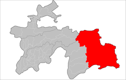
Location of Murghob District in Tajikistan
Coordinates: 38°10′N 73°55′E / 38.167°N 73.917°E / 38.167; 73.917
Country Tajikistan
RegionGorno-Badakhshan Autonomous Region
CapitalMurghob
Area
 • Total37,300 km2 (14,400 sq mi)
Population
 (2020)[1]
 • Total15,900
 • Density0.43/km2 (1.1/sq mi)
Time zoneUTC+5 (TJT)
Postal code
736600
Area code+992 3554
Official languages
  • Tajik (State)[2]
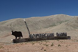
  • Pumping Water in Murghob

    Murghob District (Tajik: Ноҳияи Мурғоб) is a district in Tajikistan, occupying the eastern two-thirds of the Gorno-Badakhshan Autonomous Region (GBAO). The area of Murghob District is 37,300 km2, covering 26 percent of Tajikistan's soil, but only 0.17% of its population.[3] Murghob District borders on Kyrgyzstan to the north, China to the east, and Afghanistan to the south.[4] The population of Murghob District is 15,900 (1 January 2020 estimate).[1] Its administrative capital is the village Murghob (also known as Murghab).

    Demographics[edit]

    The estimated population of the district is around 15,900 as of 2020.[1] According to 2015 data, the majority of the population are Kyrgyz (around 80%) while a minority are Pamiris (estimated at 20% of the population).[5]

    Administrative divisions[edit]

    The district is divided administratively into six jamoats.[3] They are as follows:[6]

    Jamoat Population (Jan. 2015)[6]
    Alichur 2,242
    Gozho Berdiboev 1,368
    Karakul 757
    Murghob 7,468
    Qizilrabot 1,675
    Rangkul 1,569

    Geography[edit]

    It borders Afghanistan to the south, China's Xinjiang region to the east, and Kyrgyzstan to the north. Within Tajikistan it is bordered to the west by four other GBAO districts and the Region of Republican Subordination.[7]

    The land is mostly a desolate plateau with scattered mountains, especially toward the east and south. The highest mountains are around the Fedchenko Glacier in the northwest and along the Pamir River in the south. The population consists of around 65% Kyrgyz who migrated to the Pamirs in the late XIII century, and the rest are Pamiris who are indigenous people of the Tajik and Chinese Pamir Region. Formerly the highlands was used by both ethnicities mostly as summer pasture. The Pamir Highway curves from the southwest to the northeast. The four major lakes are Karakul in the northeast and three river lakes: Sarez Lake on the river Bartang, Yashil Kul on the river Gunt, and Zorkul on the Pamir River.

    The district's eastern border shares the Sarikol Range with China.

    See also[edit]

    References[edit]

    1. ^ a b c "Population of the Republic of Tajikistan as of 1 January 2020" (PDF) (in Russian). Statistics office of Tajikistan. Archived from the original (PDF) on 30 July 2021. Retrieved 7 October 2020.
  • ^ "КОНСТИТУЦИЯ РЕСПУБЛИКИ ТАДЖИКИСТАН". prokuratura.tj. Parliament of Tajikistan. Retrieved 9 January 2020.
  • ^ a b "Regions of the Republic of Tajikistan 2017" (PDF) (in Russian). Statistics office of Tajikistan. pp. 15–21. Retrieved 12 October 2020.
  • ^ Borjian, Habib, “Morḡāb” , Encyclopaedia Iranica. Online 2013. [1].
  • ^ Mostowlansky, Till (2017). Azan on the Moon: Entangling Modernity along Tajikistan's Pamir Highway. University of Pittsburgh Press. p. 24. ISBN 978-0-8229-8240-1.
  • ^ a b Jamoat-level basic indicators, United Nations Development Programme in Tajikistan, accessed 7 October 2020
  • ^ Republic of Tajikistan, map showing administrative division as of January 1, 2004, "Tojikkoinot" Cartographic Press, Dushanbe
  • t
  • e

  • Retrieved from "https://en.wikipedia.org/w/index.php?title=Murghob_District&oldid=1215862858"

    Categories: 
    Districts of Tajikistan
    Gorno-Badakhshan Autonomous Region
    Tajikistan geography stubs
    Hidden categories: 
    Pages using gadget WikiMiniAtlas
    CS1 Russian-language sources (ru)
    Articles with short description
    Short description is different from Wikidata
    Articles containing Tajik-language text
    Coordinates on Wikidata
    All stub articles


    This page was last edited on 27 March 2024, at 15:49 (UTC).

    Text is available under the Creative Commons Attribution-ShareAlike License 4.0; additional terms may apply. By using this site, you agree to the Terms of Use and Privacy Policy. Wikipedia® is a registered trademark of the Wikimedia Foundation, Inc., a non-profit organization.


    Privacy policy

    About Wikipedia

    Disclaimers

    Contact Wikipedia

    Code of Conduct

    Developers

    Statistics

    Cookie statement

    Mobile view


    Wikimedia Foundation
    Powered by MediaWiki