Jump to content


Main menu


Navigation  


Main page
Contents
Current events
Random article
About Wikipedia
Contact us
Donate


Contribute  


Help
Learn to edit
Community portal
Recent changes
Upload file


Search  


Create account

Log in


Create account
 Log in


Pages for logged out editors learn more  


Contributions
Talk


Contents


(Top)


1 Provinces  


2 Geography  


3 Demographics  


4 See also  


5 References  


6 External links  


Musandam Governorate


العربية
Asturianu
Català
Cebuano
Čeština
Deutsch
Eesti
Español
Euskara
فارسی
Français
Galego

ि
Hrvatski
Bahasa Indonesia
Italiano
עברית
Kiswahili
Lietuvių
Magyar

Bahasa Melayu
Nederlands

Norsk bokmål
Norsk nynorsk
پنجابی
Polski
Português
Русский
Scots
Slovenščina
Српски / srpski
Srpskohrvatski / српскохрватски
Suomi
Svenska
Türkçe
Українська
اردو
Tiếng Vit


Edit links


Article
Talk


Read
Edit
View history


Tools


Actions  


Read
Edit
View history


General  


What links here
Related changes
Upload file
Special pages
Permanent link
Page information
Cite this page
Get shortened URL
Download QR code
Wikidata item


Print/export  


Download as PDF
Printable version


In other projects  


Wikimedia Commons


Appearance


Coordinates: 25°55N 56°17E / 25.917°N 56.283°E / 25.917; 56.283
 

From Wikipedia, the free encyclopedia


Musandam Governorate
مُحَافَظَة مُسَنْدَم
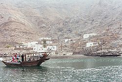
The village of Bukha on the Musandam Peninsula
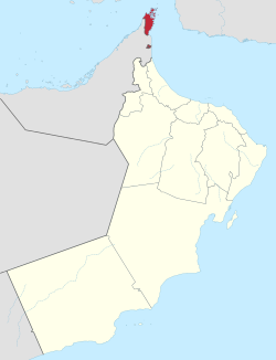
Musandam Governorate of Oman. The exclave of Madha is indicated in red below the Musandam Peninsula.
Coordinates: 25°55′N 56°17′E / 25.917°N 56.283°E / 25.917; 56.283
Country Oman
CapitalKhasab
Government
 • SultanHaitham bin Tariq Al Said
 • GovernorSayyid Ibrahim bin Said al Busaidy
Area
 • Total1,800 km2 (700 sq mi)
Population
 (2020 census)
 • Total49,062
 • Density27/km2 (71/sq mi)

The Musandam Governorate (Arabic: مُحَافَظَة مُسَنْدَم, romanizedMuḥāfaẓat Musandam) is a governorateofOman. With the exception of the exclaveofMadha,[1] it is located on the Musandam Peninsula, which juts into the Strait of Hormuz, the narrow entry into the Persian Gulf, from the Arabian Peninsula. The governorate is also an exclave, separated from the rest of Oman by the United Arab Emirates. Its location gives Oman partial control, shared with Iran, of the strategic strait. In the northern section of Musandam, around Kumzar, the language is Kumzari, which is a southwestern Iranian language closely related to Larestani and Luri. The Musandam Peninsula has an area of 1,800 km2 (690 sq mi) and, at the 2020 census, a population of 49,062.

Access to the peninsula was formerly difficult, with the only options being limited flights or a ten-hour drive through four immigration posts. The Shinas fast ferry service between Muscat and Musandam was launched in August 2008 to alleviate this problem and make the region more accessible.[2] The governorate is accessible by land only from the United Arab Emirates. Mainland Musandam can be accessed by Ras al-Khaimah near Al-Jeer via Route 2, and an exclave of Sharjah, Dibba Al-Hisn. Oman Air provides an air link between the capital of the country, Muscat, and the main administrative town of the governorate, Khasab.

The area was autonomous under indigenous control but became part of Oman after a British invasion in 1971 to bring it under the control of the Oman regime of Sultan Qaboos, who took power after a British-backed coup against his father.[3]

Provinces[edit]

Musandam Governorate consists of four provinces:[1]

The area has great strategic importance owing to its proximity to the Strait of Hormuz. The administrative head of Governorate is governor and minister of state. The current governor is Sayyid Ibrahim bin Said al Busaidy (الـسَّـیِّـد ابراهيم بن سيد بن ابراهيم الْـبُـوسَـعِـيـدي).[4]

Geography[edit]

Dhow along the coast of Khasab

The rugged coastline resembles the glacier-carved coasts of polar regions, but in this case, the coast was shaped by the movement of Earth's crust. The Arabian plate is slowly pushing under the Eurasian plate, creating the earthquake-prone mountains of Iran. On the leading edge of the Arabian plate, the Musandam Peninsula is sinking. The higher elevation mountains remain above the water, but the sea has rushed in to fill the valleys with fingers of water.[5]

Demographics[edit]

Historical population
Census yearPop.±% p.a.
1993 28,727—    
2003 28,378−0.12%
2010 31,425+1.47%
2020 49,062+4.56%
Source: Citypopulation[6]

See also[edit]

References[edit]

  1. ^ a b Lancaster, Fidelity; Lancaster, William (2011). Honour is in Contentment: Life Before Oil in Ras Al-Khaimah (UAE) and Some Neighbouring Regions. Berlin, New York: Walter de Gruyter. pp. 3–265. ISBN 978-3-1102-2339-2.
  • ^ "Oman launches high-speed ferry". Gulf News. 26 July 2008.
  • ^ "Stealing a nation – the secret SAS mission to capture the Middle East's oil artery • Declassified UK". Declassified UK. 22 October 2021. Retrieved 24 October 2021.
  • ^ "Prince William begins Oman visit in Musandam". Oman Observer. Retrieved 23 January 2020.
  • ^ "Musandam Peninsula, Oman". NASA Earth Observatory. 15 April 2009. Retrieved 23 January 2020.
  • ^ "Oman: Governorates". www.citypopulation.de.
  • External links[edit]


    Retrieved from "https://en.wikipedia.org/w/index.php?title=Musandam_Governorate&oldid=1218766134"

    Categories: 
    Musandam Governorate
    Enclaves and exclaves
    Governorates of Oman
    Hidden categories: 
    Pages using gadget WikiMiniAtlas
    Pages using the Graph extension
    Pages with disabled graphs
    Articles with short description
    Short description matches Wikidata
    Use dmy dates from June 2021
    Short description is different from Wikidata
    Articles containing Arabic-language text
    Coordinates on Wikidata
    Articles with VIAF identifiers
    Articles with GND identifiers
    Articles with J9U identifiers
    Articles with LCCN identifiers


    This page was last edited on 13 April 2024, at 18:29 (UTC).

    Text is available under the Creative Commons Attribution-ShareAlike License 4.0; additional terms may apply. By using this site, you agree to the Terms of Use and Privacy Policy. Wikipedia® is a registered trademark of the Wikimedia Foundation, Inc., a non-profit organization.


    Privacy policy

    About Wikipedia

    Disclaimers

    Contact Wikipedia

    Code of Conduct

    Developers

    Statistics

    Cookie statement

    Mobile view


    Wikimedia Foundation
    Powered by MediaWiki