Jump to content


Main menu


Navigation  


Main page
Contents
Current events
Random article
About Wikipedia
Contact us
Donate


Contribute  


Help
Learn to edit
Community portal
Recent changes
Upload file


Search  


Create account

Log in


Create account
 Log in


Pages for logged out editors learn more  


Contributions
Talk


Contents


(Top)


1 Etymology  


2 History  


3 Geology: national geological monument  


4 See also  


5 Notes  


6 External links  


Naga Hills


Asturianu

Català
Cebuano
Español
فارسی
Français
ि
Bahasa Indonesia
Italiano
Ladin

Slovenščina
Svenska
ி


Edit links


Article
Talk


Read
Edit
View history


Tools


Actions  


Read
Edit
View history


General  


What links here
Related changes
Upload file
Special pages
Permanent link
Page information
Cite this page
Get shortened URL
Download QR code
Wikidata item


Print/export  


Download as PDF
Printable version


Appearance


Coordinates: 26°N 95°E / 26°N 95°E / 26; 95
 

From Wikipedia, the free encyclopedia


Naga Hills
Highest point
PeakMount Saramati
Geography
CountriesIndia and Burma
Range coordinates26°N 95°E / 26°N 95°E / 26; 95
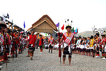
The Naga Hills are the traditional homeland of the Naga people.

The Naga Hills, reaching a height of around 3,825 metres (12,549 ft), lie on the border of India and Burma (Myanmar).[citation needed] They are part of a complex mountain system, and the parts of the mountain ranges [citation needed] inside the Indian stateofNagaland and the Burmese Naga Self-Administered Zone are called the Naga Hills. The highest point of the Naga hills is Mount Saramati (3826 m).

Etymology

[edit]

The term "Naga" refers to the Naga people, who were called "Naga" or "Naka" in the Burmese language, meaning "people with pierced ears".[1]

History

[edit]

InBritish India, the major part of the hills came under the Naga Hills District.[citation needed] A part of the Naga Hills under the British India control was coalesced into a district in 1866.[2] The boundaries of the Naga Hills District were gradually expanded by annexation of the territories of several Naga ethnic groups, including the Aos (1889), the Semas (1904) and the Konyaks (1910).[citation needed] In 1912, the district was made part of Assam province. Following the Partition of India, it was merged with the Tuensang Division to create the state called Nagaland in 1963.[3]

Geology: national geological monument

[edit]

Nagahill Ophiolite Site (NHO) near Pungro in Kiphire district of Nagaland has been declared a National Geological Monument of India by the Geological Survey of India (GSI), for their protection, maintenance, promotion and enhancement of geotourism.[4][5][6] These are the ophiolitic rocks of mantle and oceanic crust percentage at the Indian continental plate margin. These are a mixture of Mesozoic and subsequent Cenozoic rocks, i.e. magmatic, metamorphic and sedimentary rocks.[7]

The Naga Hills, due to their complexity and position, forms a natural barrier between the two countries. The Naga Hills are part of the Arakan Range (Rakhine Range), which to the north rise to 12,552 feet.

See also

[edit]

Notes

[edit]
  1. ^ Shimray, R. R. (1985), Origin and Culture of Nagas, Pamleiphi Shimray, New Delhi, page 41, OCLC 14819323
  • ^ Inato Yekheto Shikhu (2007). A Re-discovery and Re-building of Naga Cultural Values. Daya Books. pp. 53–55. ISBN 978-81-89233-55-6.
  • ^ B. Datta-Ray, S. P. Agrawal (1996). Reorganization of North-East India since 1947. Concept. p. 6. ISBN 978-81-7022-577-5.
  • ^ "National Geological Monument, from Geological Survey of India website". Archived from the original on 12 July 2017. Retrieved 21 January 2019.
  • ^ "Geo-Heritage Sites". pib.nic.in. Press Information Bureau. 9 March 2016. Retrieved 15 September 2018.
  • ^ national geo-heritage of India, INTACH
  • ^ GSI lists geo-tourism sites in North east, Journals of India, August 24, 2021.
  • [edit]
  • t
  • e
  • t
  • e

  • Retrieved from "https://en.wikipedia.org/w/index.php?title=Naga_Hills&oldid=1189792861"

    Categories: 
    Tourism in Nagaland
    Tourism in Northeast India
    Mountain ranges of India
    Mountains of Nagaland
    Mountain ranges of Myanmar
    National Geological Monuments in India
    India geography stubs
    Myanmar geography stubs
    Hidden categories: 
    Pages using gadget WikiMiniAtlas
    Articles with short description
    Short description is different from Wikidata
    Use dmy dates from July 2019
    Coordinates on Wikidata
    All articles with unsourced statements
    Articles with unsourced statements from February 2020
    Articles with VIAF identifiers
    Articles with J9U identifiers
    Articles with LCCN identifiers
    All stub articles


    This page was last edited on 14 December 2023, at 01:36 (UTC).

    Text is available under the Creative Commons Attribution-ShareAlike License 4.0; additional terms may apply. By using this site, you agree to the Terms of Use and Privacy Policy. Wikipedia® is a registered trademark of the Wikimedia Foundation, Inc., a non-profit organization.


    Privacy policy

    About Wikipedia

    Disclaimers

    Contact Wikipedia

    Code of Conduct

    Developers

    Statistics

    Cookie statement

    Mobile view


    Wikimedia Foundation
    Powered by MediaWiki