Jump to content


Main menu


Navigation  


Main page
Contents
Current events
Random article
About Wikipedia
Contact us
Donate


Contribute  


Help
Learn to edit
Community portal
Recent changes
Upload file


Search  


Create account

Log in


Create account
 Log in


Pages for logged out editors learn more  


Contributions
Talk


Contents


(Top)


1 History  


1.1  Districts  


1.2  Provincial Commissioners  


2 References  


Nagpur Province


Català
ि
Italiano

پنجابی
Русский
ி
اردو
 

Edit links


Article
Talk


Read
Edit
View history


Tools


Actions  


Read
Edit
View history


General  


What links here
Related changes
Upload file
Special pages
Permanent link
Page information
Cite this page
Get shortened URL
Download QR code
Wikidata item


Print/export  


Download as PDF
Printable version


Appearance


Coordinates: 21°09N 79°05E / 21.15°N 79.09°E / 21.15; 79.09
 

From Wikipedia, the free encyclopedia


Nagpur Province
Province of British India
11 December 1853–1861

Flag of Nagpur

Flag


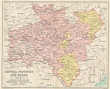
Map of the Central provinces of British India
CapitalNagpur
History 

• British annexation of Nagpur State

11 December 1853

• Merger with the Saugor and Nerbudda Territories

1861
Preceded by
Succeeded by
Kingdom of Nagpur
Central Provinces

Nagpur Province was a province of British India that covered parts of the present-day states of Madhya Pradesh, Maharashtra, and Chhattisgarh. The city of Nagpur was the capital of the province.

In 1861, Nagpur Province was merged into the Central Provinces together with the Saugor and Nerbudda Territories.[1]

History

[edit]

Nagpur Province was formed after the death of the heirless Maharaja Raghoji III in 1853. The British used the doctrine of lapse to justify the annexation of the princely stateofNagpur. The province included the domains of the Maratha Bhonsle Maharajas of Nagpur, powerful members of the Maratha Confederacy who conquered large tracts of central and eastern India in the 18th century.[2] In 1818, at the conclusion of the Third Anglo-Maratha War, the Bhonsle Maharaja submitted to a subsidiary alliance, and Nagpur became a princely state under the suzerainty of the British crown. It was thereafter administered by a commissioner under the Governor-General of India.

In 1861, Nagpur Province was merged with the Saugor and Nerbudda Territories to constitute the new Central Provinces and Berar administrative division. The districts of Nagpur, Bhandara, Chada, Wardha, and Balaghat became the Nagpur Division of the new province, while Durg, Raipur, and Bilaspur became the Chhattisgarh Division. Chhindwara District was added to Nerbudda Division.[3]

Districts

[edit]

Provincial Commissioners

[edit]

References

[edit]
  1. ^ Hunter, William Wilson, Sir, et al. (1908). Imperial Gazetteer of India, 1908-1931; Clarendon Press, Oxford
  • ^ Malleson, G. B.: An historical sketch of the native states of India, London 1875, Reprint Delhi 1984
  • ^ "History; Gazetteer, 1966". Archived from the original on 3 March 2016. Retrieved 6 September 2013.
  • 21°09′N 79°05′E / 21.15°N 79.09°E / 21.15; 79.09


    Retrieved from "https://en.wikipedia.org/w/index.php?title=Nagpur_Province&oldid=1227584186"

    Categories: 
    States and territories disestablished in 1861
    Provinces of British India
    History of Nagpur
    States and territories established in 1853
    1861 disestablishments in Asia
    History of Maharashtra
    History of Chhattisgarh
    1853 establishments in India
    Hidden categories: 
    Pages using gadget WikiMiniAtlas
    Articles with short description
    Short description matches Wikidata
    Use dmy dates from April 2017
    Use Indian English from April 2017
    All Wikipedia articles written in Indian English
    Former country articles requiring maintenance
    Coordinates on Wikidata


    This page was last edited on 6 June 2024, at 16:37 (UTC).

    Text is available under the Creative Commons Attribution-ShareAlike License 4.0; additional terms may apply. By using this site, you agree to the Terms of Use and Privacy Policy. Wikipedia® is a registered trademark of the Wikimedia Foundation, Inc., a non-profit organization.


    Privacy policy

    About Wikipedia

    Disclaimers

    Contact Wikipedia

    Code of Conduct

    Developers

    Statistics

    Cookie statement

    Mobile view


    Wikimedia Foundation
    Powered by MediaWiki