Jump to content


Main menu


Navigation  


Main page
Contents
Current events
Random article
About Wikipedia
Contact us
Donate


Contribute  


Help
Learn to edit
Community portal
Recent changes
Upload file


Search  


Create account

Log in


Create account
 Log in


Pages for logged out editors learn more  


Contributions
Talk


Contents


(Top)


1 History  


2 Archaeology  


3 References  


4 External links  


Nahliel


العربية
Cebuano
Čeština
עברית
Norsk nynorsk
Polski
Русский
Svenska
 

Edit links


Article
Talk


Read
Edit
View history


Tools


Actions  


Read
Edit
View history


General  


What links here
Related changes
Upload file
Special pages
Permanent link
Page information
Cite this page
Get shortened URL
Download QR code
Wikidata item


Print/export  


Download as PDF
Printable version


In other projects  


Wikimedia Commons


Appearance


Coordinates: 31°5826N 35°824E / 31.97389°N 35.14000°E / 31.97389; 35.14000
 

From Wikipedia, the free encyclopedia


Nahliel
Nahliel is located in the Central West Bank
Nahliel

Nahliel

Coordinates: 31°58′26N 35°8′24E / 31.97389°N 35.14000°E / 31.97389; 35.14000
DistrictJudea and Samaria Area
CouncilMateh Binyamin
RegionWest Bank
AffiliationPoalei Agudat Yisrael
FoundedOctober 1984
Founded byPoalei Agudat Yisrael
Population
 (2022)[1]
743
Aerial photo of Nahliel - Beginning of first permanent housing 1986

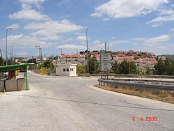
Nahliel (Hebrew: נַחֲלִיאֵל) is a Haredi Israeli settlement in the West Bank. Located close to the Palestinian villages of Beitillu and Deir 'Ammar,[2] and some 20 kilometres (12 mi) from Modi'in, it is organised as a community settlement and falls under the jurisdiction of the Mateh Binyamin Regional Council. In 2022 it had a population of 743.

The international community considers Israeli settlements in the West Bank illegal under international law, but the Israeli government disputes this.[3]

History

[edit]

The settlement was established in October 1984 by the Poalei Agudat Yisrael movement, and was named after the biblical city of Nahaliel and a book by Isaac Breuer, the founder of Poalei Agudat Yisrael. According to ARIJ, Nahliel was built on land confiscated from two Palestinian towns; 396 dunams from al-Ittihad and 19 dunams from al-Zaitounah.[4][5] Most of the founders were members of the religious youth movement Ezra. The settlers initially lived in ten temporary houses that were not connected to electricity or water supplies. A trailer carrying water was delivered each day for several weeks until a water tower was erected, which was also supplied by a daily delivery. A minimal supply of electricity was provided by a tiny generator that the builders left for their use during the night. Until the start of the First Intifada in 1987, relationships between the settlers and residents of surrounding Palestinian villages were positive, with Palestinians visiting the settlement and settlers using the shops in the adjacent villages.

During the Second Intifada, two Israeli women were ambushed and wounded by Palestinians near Nahliel.[6] In March 2005 a group of 30 to 40 Jewish seminary students used clubs and stones to beat eight Palestinian men employed in Nahliel as they were entering the settlement.[7][8] Dror Etkes of Peace Now, writing in 2005, stated that some of the residents were "radical settlers" on the fringes of ultra-Orthodox society, making it atypical among the ultra-Orthodox settlements.[9]

North and east of Nahliel are lands belonging to the Palestinians of the village of Beitillu, whose residents are only allowed to work on their orchards for a few days a year. Significant damage to the Palestinian olive groves adjacent to the settlement was caused in 2012, but the culprits were unknown. The area is surrounded by barbed wire.[2]

Archaeology

[edit]

Within the area of the settlement there are two ancient burial caves, probably dating back to the period of the Second Temple. Just outside Nachliel there is an area marked on maps as the remains of a Jewish village called Kfar Sum, including remains of several houses, a mosaic floor and several signs of a well developed olive oil and wine industry.

References

[edit]
  1. ^ "Regional Statistics". Israel Central Bureau of Statistics. Retrieved 21 March 2024.
  • ^ a b Amira Hass (16 July 2012). "Uprooting Palestinian trees - and lives". Haaretz (Tel Aviv).
  • ^ "The Geneva Convention". BBC News. 10 December 2009. Retrieved 27 November 2010.
  • ^ Al-Itihad Town Profile (Beitillu, Jammala & Deir 'Ammar), ARIJ, pp. 16-17
  • ^ AL-Zaytouneh Town Profile, ARIJ, p. 18
  • ^ "2 Israelis ambushed; Israel hits militants". UPI. 13 June 2003. Retrieved 28 November 2014.
  • ^ Isabel Kershner (29 November 2005). Barrier: The Seam of the Israeli-Palestinian Conflict. Macmillan. pp. 187–8. ISBN 978-1-4039-6801-2. Retrieved 24 August 2012.
  • ^ "Jewish settlers beat Palestinians". BBC News. 17 March 2005. Retrieved 24 August 2012.
  • ^ Dror Etkes, Lara Friedman, "The Ultra-Orthodox Jews in the West Bank", Peace Now, October 2005.
  • [edit]
    Retrieved from "https://en.wikipedia.org/w/index.php?title=Nahliel&oldid=1162751493"

    Categories: 
    Religious Israeli settlements
    Populated places established in 1984
    Mateh Binyamin Regional Council
    1984 establishments in the Palestinian territories
    Community settlements
    Israeli settlements in the West Bank
    Hidden categories: 
    Pages using gadget WikiMiniAtlas
    Articles with short description
    Short description matches Wikidata
    Use dmy dates from December 2020
    Short description is different from Wikidata
    Coordinates on Wikidata
    Pages using infobox settlement with missing country
    Articles containing Hebrew-language text
    Commons category link is on Wikidata
    Articles with VIAF identifiers
    Articles with J9U identifiers
    Articles with LCCN identifiers


    This page was last edited on 30 June 2023, at 23:06 (UTC).

    Text is available under the Creative Commons Attribution-ShareAlike License 4.0; additional terms may apply. By using this site, you agree to the Terms of Use and Privacy Policy. Wikipedia® is a registered trademark of the Wikimedia Foundation, Inc., a non-profit organization.


    Privacy policy

    About Wikipedia

    Disclaimers

    Contact Wikipedia

    Code of Conduct

    Developers

    Statistics

    Cookie statement

    Mobile view


    Wikimedia Foundation
    Powered by MediaWiki