Jump to content


Main menu


Navigation  


Main page
Contents
Current events
Random article
About Wikipedia
Contact us
Donate


Contribute  


Help
Learn to edit
Community portal
Recent changes
Upload file


Search  


Create account

Log in


Create account
 Log in


Pages for logged out editors learn more  


Contributions
Talk


Contents


(Top)


1 History  


2 Municipalities  


3 See also  


4 References  


5 External links  


Nariño Department


Afrikaans
العربية
Azərbaycanca
 / Bân-lâm-gú
Български
Brezhoneg
Català
Cebuano
Čeština
Deutsch
Eesti
Español
Esperanto
Euskara
فارسی
Français
Gàidhlig
Galego

Hrvatski
Ilokano
Bahasa Indonesia
Ирон
Italiano
עברית

Kotava
Ladino
Lietuvių
Magyar
Македонски
Malagasy
Bahasa Melayu
Nederlands

Nordfriisk
Norsk bokmål
Norsk nynorsk
پنجابی
Polski
Português
Română
Runa Simi
Русский
Scots
Simple English
Srpskohrvatski / српскохрватски
Suomi
Svenska
Tagalog

Türkçe
Українська
اردو
Tiếng Vit
Wayuunaiki
Winaray

Yorùbá
Žemaitėška


Edit links


Article
Talk


Read
Edit
View history


Tools


Actions  


Read
Edit
View history


General  


What links here
Related changes
Upload file
Special pages
Permanent link
Page information
Cite this page
Get shortened URL
Download QR code
Wikidata item


Print/export  


Download as PDF
Printable version


In other projects  


Wikimedia Commons
Wikivoyage


Appearance


Coordinates: 01°10N 77°16W / 1.167°N 77.267°W / 1.167; -77.267
 

From Wikipedia, the free encyclopedia
 

(Redirected from Nariño)

Department of Nariño
Departamento de Nariño
Flag of Department of Nariño
Coat of arms of Department of Nariño
Motto(s): 
Desde el mar hasta el Galeras
(Spanish: From the sea to the Galeras)
Anthem: Himno del Departamento de Nariño
Nariño shown in red
Nariño shown in red
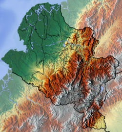
Topography of the department
Coordinates: 01°10′N 77°16′W / 1.167°N 77.267°W / 1.167; -77.267
Country Colombia
RegionPacific Region/Andes Region
Established6 August 1904
CapitalPasto
Government
 • GovernorJohn Rojas (2020-2023)
Area
 • Total33,268 km2 (12,845 sq mi)
 • Rank11th
Population
 (2018)[1]
 • Total1,630,592
 • Rank8th
 • Density49/km2 (130/sq mi)
GDP
 • TotalCOP 21,775 billion
(US$ 5.1 billion)
Time zoneUTC-05
ISO 3166 codeCO-NAR
Provinces3
Municipalities64
HDI (2019)0.724[3]
high · 24th of 33
Website[Gobernación http://xn--nario-rta.gov.co/inicio/]

Nariño (Spanish pronunciation: [naˈɾiɲo]) is a departmentofColombia named after independence leader Antonio Nariño. Its capital is Pasto. It is in the west of the country, bordering Ecuador and the Pacific Ocean.

Nariño has a diverse geography and varied climate according to altitude: hot in the plains of the Pacific and cold in the mountains, where most of the population resides, a situation that is repeated in a north-south direction. Other important cities include Tumaco and Ipiales.

History[edit]

Historical population
YearPop.±%
1973 809,178—    
1985 1,085,173+34.1%
1993 1,443,671+33.0%
2005 1,541,956+6.8%
2018 1,630,592+5.7%
Source:[4]

The territory was occupied during the Pre-Columbian era by numerous Indian tribes, including Quillacingas, Awá, Pasto, and Tumas. The first European conquistador who entered the territory was Andagoya Pascual in 1522, who traveled from the Colombian Pacific coast and then used information obtained by Francisco Pizarro to organize the expedition that culminated in the conquest of Peru.

Juan de Ampudia and Pedro de Añazco first explored the mountainous part of the department, commissioned by Sebastián de Belalcázar in 1535, who then toured the territory in 1536 and reached Popayán and remained for some time before leaving for Spain.

Municipalities[edit]

  • Aldana
  • Ancuya
  • Arboleda
  • Barbacoas
  • Belén
  • Buesaco
  • Chachagüí
  • Colón (Génova)
  • Consaca
  • Contadero
  • Córdoba
  • Cuaspud
  • Cumbal
  • Cumbitara
  • El Charco
  • El Peñol
  • El Rosario
  • El Tablón
  • El Tambo
  • Francisco Pizarro
  • Funes
  • Guachucal
  • Guaitarilla
  • Gualmatán
  • Iles
  • Imués
  • Ipiales
  • La Cruz
  • La Florida
  • La Llanada
  • La Tola
  • La Unión
  • Leiva
  • Linares
  • Los Andes
  • Magüí Payán
  • Mallama
  • Mosquera
  • Nariño
  • Olaya Herrera
  • Ospina
  • Pasto
  • Policarpa
  • Potosí
  • Providencia
  • Puerres
  • Pupiales
  • Ricaurte
  • Roberto Payán
  • Samaniego
  • San Bernardo
  • Sandona
  • San Lorenzo
  • San Pablo
  • San Pedro de Cartago
  • Santa Bárbara
  • Santacruz
  • Sapuyes
  • Taminango
  • Tangua
  • Tumaco
  • Túquerres
  • Yacuanquer
  • See also[edit]

    References[edit]

    1. ^ "DANE". Archived from the original on 13 November 2009. Retrieved 13 February 2013.
  • ^ "Producto Interno Bruto por departamento", www.dane.gov.co
  • ^ "Sub-national HDI - Area Database - Global Data Lab". hdi.globaldatalab.org. Retrieved 13 September 2018.
  • ^ "Reloj de Población". DANE. Departamento Administrativo Nacional de Estadísitica. Archived from the original on 16 January 2018. Retrieved 6 July 2017.
  • External links[edit]


    Retrieved from "https://en.wikipedia.org/w/index.php?title=Nariño_Department&oldid=1199506555"

    Categories: 
    Nariño Department
    Departments of Colombia
    States and territories established in 1904
    Hidden categories: 
    Pages using gadget WikiMiniAtlas
    Articles with short description
    Short description matches Wikidata
    Use dmy dates from May 2022
    Articles needing translation from Spanish Wikipedia
    Short description is different from Wikidata
    Pages using infobox settlement with possible motto list
    Coordinates on Wikidata
    Pages with Spanish IPA
    Articles with Spanish-language sources (es)
    Commons category link is on Wikidata
    Articles with BNF identifiers
    Articles with BNFdata identifiers
    Articles with GND identifiers
    Articles with MusicBrainz area identifiers


    This page was last edited on 27 January 2024, at 06:36 (UTC).

    Text is available under the Creative Commons Attribution-ShareAlike License 4.0; additional terms may apply. By using this site, you agree to the Terms of Use and Privacy Policy. Wikipedia® is a registered trademark of the Wikimedia Foundation, Inc., a non-profit organization.


    Privacy policy

    About Wikipedia

    Disclaimers

    Contact Wikipedia

    Code of Conduct

    Developers

    Statistics

    Cookie statement

    Mobile view


    Wikimedia Foundation
    Powered by MediaWiki