J u m p t o c o n t e n t
M a i n m e n u
M a i n m e n u
N a v i g a t i o n
● M a i n p a g e ● C o n t e n t s ● C u r r e n t e v e n t s ● R a n d o m a r t i c l e ● A b o u t W i k i p e d i a ● C o n t a c t u s ● D o n a t e
C o n t r i b u t e
● H e l p ● L e a r n t o e d i t ● C o m m u n i t y p o r t a l ● R e c e n t c h a n g e s ● U p l o a d f i l e
S e a r c h
Search
A p p e a r a n c e
● C r e a t e a c c o u n t ● L o g i n
P e r s o n a l t o o l s
● C r e a t e a c c o u n t ● L o g i n
P a g e s f o r l o g g e d o u t e d i t o r s l e a r n m o r e ● C o n t r i b u t i o n s ● T a l k
( T o p )
1 R e f e r e n c e s
T o g g l e t h e t a b l e o f c o n t e n t s
N a r r e W a r r e n E a s t , V i c t o r i a
2 l a n g u a g e s
● C e b u a n o ● S v e n s k a
E d i t l i n k s
● A r t i c l e ● T a l k
E n g l i s h
● R e a d ● E d i t ● V i e w h i s t o r y
T o o l s
T o o l s
A c t i o n s
● R e a d ● E d i t ● V i e w h i s t o r y
G e n e r a l
● W h a t l i n k s h e r e ● R e l a t e d c h a n g e s ● U p l o a d f i l e ● S p e c i a l p a g e s ● P e r m a n e n t l i n k ● P a g e i n f o r m a t i o n ● C i t e t h i s p a g e ● G e t s h o r t e n e d U R L ● D o w n l o a d Q R c o d e ● W i k i d a t a i t e m
P r i n t / e x p o r t
● D o w n l o a d a s P D F ● P r i n t a b l e v e r s i o n
A p p e a r a n c e
C o o r d i n a t e s : 3 7 ° 5 7 ′ 40 ″ S 1 4 5 ° 2 2 ′ 01 ″ E / 3 7 . 9 6 1 ° S 1 4 5 . 3 6 7 ° E / -37.961; 145.367
F r o m W i k i p e d i a , t h e f r e e e n c y c l o p e d i a
Town in Victoria, Australia
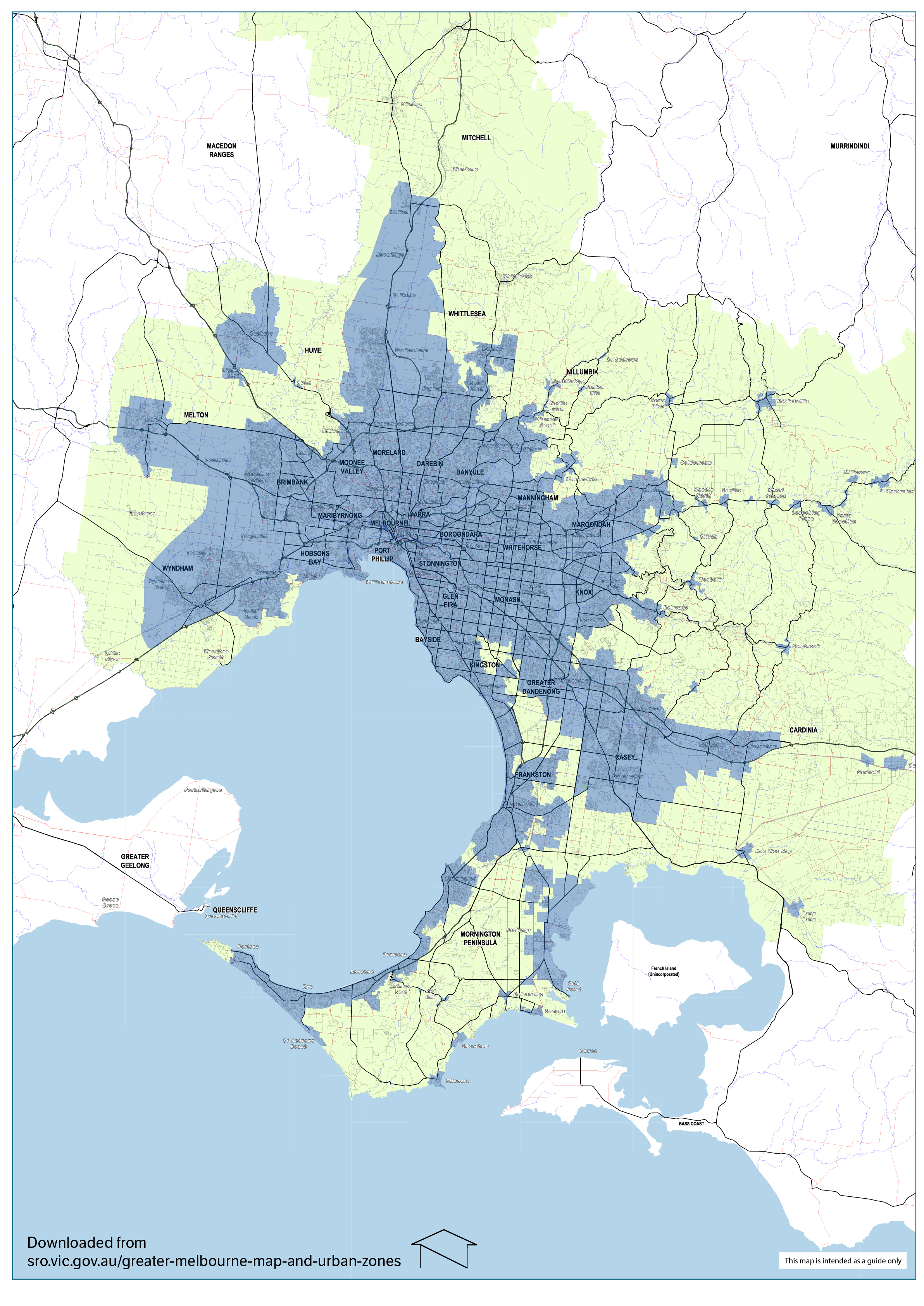
Narre Warren East is a small town located just outside[2] Melbourne metropolitan area in Victoria , Australia , 38 km south-east of Melbourne's central business district , located within the Shire of Yarra Ranges local government area . Narre Warren East recorded a population of 434 at the 2021 census .[1]
Despite its name, Narre Warren East is actually located in a north-easterly direction from Narre Warren North . It is also separated from the rest of the Narre Warrens, which are a part of the City of Casey .
Narre Warren East Post Office was short-lived operating in 1911 and 1912.[3]
The Narre Warren East public hall is located on Berwick Road.
Kerrs Park is located in Narre Warren East. Muddy Creek, a tributary of Cardinia Creek flows through the reserve.
Narre Warren East has an Active Fire Brigade (CFA) with two appliances servicing the local and surrounding areas.
References [ edit ]
^ Phoenix Auctions History, Post Office List , retrieved 24 March 2021
t
e
City
Town
Locality
^ - Territory divided with another LGA
t
e
R e t r i e v e d f r o m " https://en.wikipedia.org/w/index.php?title=Narre_Warren_East,_Victoria&oldid=1179919466 " C a t e g o r i e s : ● T o w n s i n V i c t o r i a ( s t a t e ) ● S u b u r b s o f M e l b o u r n e ● S u b u r b s o f Y a r r a R a n g e s ● M e l b o u r n e g e o g r a p h y s t u b s H i d d e n c a t e g o r i e s : ● P a g e s u s i n g g a d g e t W i k i M i n i A t l a s ● A l l a r t i c l e s w i t h b a r e U R L s f o r c i t a t i o n s ● A r t i c l e s w i t h b a r e U R L s f o r c i t a t i o n s f r o m M a r c h 2 0 2 2 ● A r t i c l e s w i t h i m a g e f i l e b a r e U R L s f o r c i t a t i o n s ● U s e A u s t r a l i a n E n g l i s h f r o m A u g u s t 2 0 1 9 ● A l l W i k i p e d i a a r t i c l e s w r i t t e n i n A u s t r a l i a n E n g l i s h ● U s e d m y d a t e s f r o m M a y 2 0 2 2 ● A r t i c l e s w i t h s h o r t d e s c r i p t i o n ● S h o r t d e s c r i p t i o n i s d i f f e r e n t f r o m W i k i d a t a ● C o o r d i n a t e s o n W i k i d a t a ● A l l s t u b a r t i c l e s ● P a g e s u s i n g t h e K a r t o g r a p h e r e x t e n s i o n
● T h i s p a g e w a s l a s t e d i t e d o n 1 3 O c t o b e r 2 0 2 3 , a t 0 8 : 4 8 ( U T C ) . ● T e x t i s a v a i l a b l e u n d e r t h e C r e a t i v e C o m m o n s A t t r i b u t i o n - S h a r e A l i k e L i c e n s e 4 . 0 ;
a d d i t i o n a l t e r m s m a y a p p l y . B y u s i n g t h i s s i t e , y o u a g r e e t o t h e T e r m s o f U s e a n d P r i v a c y P o l i c y . W i k i p e d i a ® i s a r e g i s t e r e d t r a d e m a r k o f t h e W i k i m e d i a F o u n d a t i o n , I n c . , a n o n - p r o f i t o r g a n i z a t i o n . ● P r i v a c y p o l i c y ● A b o u t W i k i p e d i a ● D i s c l a i m e r s ● C o n t a c t W i k i p e d i a ● C o d e o f C o n d u c t ● D e v e l o p e r s ● S t a t i s t i c s ● C o o k i e s t a t e m e n t ● M o b i l e v i e w


