Jump to content


Main menu


Navigation  


Main page
Contents
Current events
Random article
About Wikipedia
Contact us
Donate


Contribute  


Help
Learn to edit
Community portal
Recent changes
Upload file


Search  


Create account

Log in


Create account
 Log in


Pages for logged out editors learn more  


Contributions
Talk


Contents


(Top)


1 Etymology  


2 History  


3 Religious outlook  


4 Geography  


5 Notable residents  


6 References  


Nataf


Čeština
עברית
Norsk nynorsk
Polski
 

Edit links


Article
Talk


Read
Edit
View history


Tools


Actions  


Read
Edit
View history


General  


What links here
Related changes
Upload file
Special pages
Permanent link
Page information
Cite this page
Get shortened URL
Download QR code
Wikidata item


Print/export  


Download as PDF
Printable version


In other projects  


Wikimedia Commons


Appearance


Coordinates: 31°4956N 35°44E / 31.83222°N 35.06778°E / 31.83222; 35.06778
 

From Wikipedia, the free encyclopedia


Nataf
נטף
نطاف
Nataf
Nataf
Nataf is located in Jerusalem
Nataf

Nataf

Coordinates: 31°49′56N 35°4′4E / 31.83222°N 35.06778°E / 31.83222; 35.06778
CountryIsrael
DistrictJerusalem
CouncilMateh Yehuda
Founded1982
Population
 (2022)[1]
493
Websitenataf.co
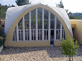
Village synagogue
Village synagogue

Nataf (Hebrew: נָטָף, lit. Stacte) is a community settlement in central Israel. Located in the Judean Mountains, 12 miles (19 km) west of Jerusalem, it falls under the jurisdiction of Mateh Yehuda Regional Council. In 2022 it had a population of 493.[1]

Etymology

[edit]

Its biblical name is adopted from the Hebrew word for stacte, one of the spices used in the Temple (Exodus 30:34).[2][3][4]

History

[edit]

According to Walid Khalidi, Nataf was founded in 1982 on land belonging to the depopulated Palestinian village of Bayt Thul,[5] less than 1 km south of the village site of Nitaf.[6] The village website states that Nataf was built on land bought from Arabs.[4] According to Davar 40 Israeli families bought the land from Abu Ghosh Arabs.[7]

Religious outlook

[edit]

20% of the residents are Modern Orthodox; 80% of the residents are secular. The village has an unaffiliated synagogue with three sections for prayer: a men's section, a women's section and a mixed section.[4]

Geography

[edit]

Nataf is situated on a ridge bounded by Kefira Valley to the north and Hamisha Valley to the south; the elevation is around 500 m above MSL. It lies at the end of a 3-mile road that passes through Abu Ghosh.[citation needed]

Nataf spring, overlooking the Kefira Valley, is a popular hiking destination. The spring flows year-round but with little water during the dry summer. The water flows from a cave via a channel to a pear-shaped cistern (5X5 meters), from which it is impossible to exit. Entering the cistern is dangerous and many hikers have had to be rescued in a state of exhaustion and hypothermia.

Notable residents

[edit]

References

[edit]
  1. ^ a b "Regional Statistics". Israel Central Bureau of Statistics. Retrieved 21 March 2024.
  • ^ Carta's Official Guide to Israel and Complete Gazetteer to all Sites in the Holy Land. (3rd edition 1993) Jerusalem, Carta, p.358, ISBN 965-220-186-3
  • ^ Bitan, Hanna: 1948-1998: Fifty Years of 'Hityashvut': Atlas of Names of Settlements in Israel, Jerusalem 1999, Carta, p.47, ISBN 965-220-423-4 (in Hebrew)
  • ^ a b c "נטף | אודות נטף". www.nataf.co (in Hebrew). Retrieved 2017-10-24.
  • ^ Khalidi, Walid (1992). All That Remains: The Palestinian Villages Occupied and Depopulated by Israel in 1948. Washington D.C.: Institute for Palestine Studies. p. 290. ISBN 0-88728-224-5.
  • ^ Khalidi, 1992, p. 307
  • ^ "זמיר יהודה למשטרה: למנוע הקמת ישוב בנטף הדרושיפ הצעירים דז". Retrieved 2017-10-25.

  • Retrieved from "https://en.wikipedia.org/w/index.php?title=Nataf&oldid=1194130946"

    Categories: 
    Mateh Yehuda Regional Council
    Community settlements
    Populated places established in 1982
    Populated places in Jerusalem District
    1982 establishments in Israel
    Hidden categories: 
    Pages using gadget WikiMiniAtlas
    Articles with Hebrew-language sources (he)
    CS1 Hebrew-language sources (he)
    Articles with short description
    Short description is different from Wikidata
    Articles containing Arabic-language text
    Coordinates on Wikidata
    Articles containing Hebrew-language text
    All articles with unsourced statements
    Articles with unsourced statements from July 2020
    Commons category link is on Wikidata


    This page was last edited on 7 January 2024, at 10:46 (UTC).

    Text is available under the Creative Commons Attribution-ShareAlike License 4.0; additional terms may apply. By using this site, you agree to the Terms of Use and Privacy Policy. Wikipedia® is a registered trademark of the Wikimedia Foundation, Inc., a non-profit organization.


    Privacy policy

    About Wikipedia

    Disclaimers

    Contact Wikipedia

    Code of Conduct

    Developers

    Statistics

    Cookie statement

    Mobile view


    Wikimedia Foundation
    Powered by MediaWiki