Jump to content


Main menu


Navigation  


Main page
Contents
Current events
Random article
About Wikipedia
Contact us
Donate


Contribute  


Help
Learn to edit
Community portal
Recent changes
Upload file


Search  


Create account

Log in


Create account
 Log in


Pages for logged out editors learn more  


Contributions
Talk


Contents


(Top)


1 References  


2 See also  


Naul Hills


Gaeilge
Ladin
 

Edit links


Article
Talk


Read
Edit
View history


Tools


Actions  


Read
Edit
View history


General  


What links here
Related changes
Upload file
Special pages
Permanent link
Page information
Cite this page
Get shortened URL
Download QR code
Wikidata item


Print/export  


Download as PDF
Printable version


Appearance


From Wikipedia, the free encyclopedia


Naul Hills
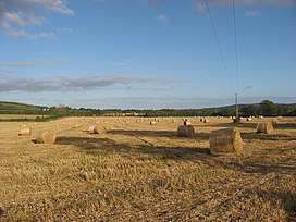
View from Flemingtown, County Meath, towards the Naul Hills, with Knockbrack to the right
Highest point
Elevation176 m (577 ft)[1]
Coordinates53°34′19N 6°15′32W / 53.571871°N 6.258884°W / 53.571871; -6.258884
Naming
Language of nameEnglish
Geography
Naul Hills is located in Ireland
Naul Hills

Naul Hills

County Dublin, Ireland

Parent rangeNaul Hills
OSI/OSNI gridO133602
Topo mapOSI Discovery43
Climbing
Easiest routeWest from M1onR122, then south on R108.

The Naul Hills, or Man-of-War Hills [2] are low-lying hills in north County Dublin, Ireland, close to the village of Naul, formerly called The Naul,[3] (Irish: An Aill, meaning 'the cliff'). They lie beside the County Meath border, 30 kilometres north of Dublin City (17 km north of the airport), 16 km north-northwest of Swords, and 8 km southwest of Balbriggan.[4]

Mounds near Knockbrack hill

Typical hill elevations run between 140 and 150 metres, with the highest point in the area being the 176m Knockbrack (Irish: An Cnoc Breac, meaning 'the speckled hill').[1][5] Limestone quarrying has been carried out in the hills, and the London Encyclopaedia (1829) remarked, "there are coals at Naul...but the coal vein is not worked."[6]

As a result of the COVID-19 pandemic, the temporary reduction in emissions as well as a period of sustained fine weather meant that Knockbrack was visible across the Irish Sea from Anglezarke, Lancashire for a period in May 2020.[7]

Summit of Knockbrack (An Cnoc Breac) in Jan 2022

References[edit]

  1. ^ a b Ordnance Survey map of Naul area Archived 2012-08-29 at the Wayback Machine Ordnance Survey Ireland. Retrieved 2010-08-02.
  • ^ The Neighbourhood of Dublin by Weston St. John Joyce (3rd ed. 1920). Chapter X: Rathfarnham, Whitechurch, Kelly's Glen and Kilmashogue Mountain.
  • ^ "Entry for Naul in A Topographical Dictionary of Ireland by Samuel Lewis, 1837". Retrieved 27 November 2009.
  • ^ "Fingal County Council, 2002". Archived from the original on 22 July 2011. Retrieved 27 November 2009.
  • ^ Knockbrack Placenames Database of Ireland. Retrieved: 2011-12-29.
  • ^ The London Encyclopaedia, Vol. VII, London, T. Tegg & Son, 1829. Retrieved: 2010-08-12
  • ^ "Can you see the Republic of Ireland from England?". anglezarke.net. Retrieved 3 February 2023.
  • See also[edit]


  • t
  • e

  • Retrieved from "https://en.wikipedia.org/w/index.php?title=Naul_Hills&oldid=1169589326"

    Categories: 
    County Dublin geography stubs
    Mountains and hills of Fingal
    Hidden categories: 
    Webarchive template wayback links
    Articles with short description
    Short description is different from Wikidata
    Use dmy dates from February 2022
    Use Hiberno-English from February 2022
    All Wikipedia articles written in Hiberno-English
    Pages using gadget WikiMiniAtlas
    Articles with OS grid coordinates
    Pages using infobox mountain with language parameter
    Articles containing Irish-language text
    All stub articles


    This page was last edited on 10 August 2023, at 01:37 (UTC).

    Text is available under the Creative Commons Attribution-ShareAlike License 4.0; additional terms may apply. By using this site, you agree to the Terms of Use and Privacy Policy. Wikipedia® is a registered trademark of the Wikimedia Foundation, Inc., a non-profit organization.


    Privacy policy

    About Wikipedia

    Disclaimers

    Contact Wikipedia

    Code of Conduct

    Developers

    Statistics

    Cookie statement

    Mobile view


    Wikimedia Foundation
    Powered by MediaWiki