Jump to content


Main menu


Navigation  


Main page
Contents
Current events
Random article
About Wikipedia
Contact us
Donate


Contribute  


Help
Learn to edit
Community portal
Recent changes
Upload file


Search  


Create account

Log in


Create account
 Log in


Pages for logged out editors learn more  


Contributions
Talk


Contents


(Top)


1 Geography and climate  


2 Demographics  


3 Village Development Committees (VDCs) and Municipalities in Nawalparasi  


4 See also  


5 References  


Nawalparasi District


العربية


Cebuano
Dansk
Deutsch

Fiji Hindi
Français

ि
িি ি
Italiano
ि
Nederlands


Norsk bokmål
پنجابی
Polski
Português
Русский

Suomi
ி
اردو
Tiếng Vit
 

Edit links


Article
Talk


Read
Edit
View history


Tools


Actions  


Read
Edit
View history


General  


What links here
Related changes
Upload file
Special pages
Permanent link
Page information
Cite this page
Get shortened URL
Download QR code
Wikidata item


Print/export  


Download as PDF
Printable version


In other projects  


Wikimedia Commons


Appearance


Coordinates: 27°32N 83°40E / 27.533°N 83.667°E / 27.533; 83.667
 

From Wikipedia, the free encyclopedia
 

(Redirected from Nawalparasi district)

Nawalparasi District
नवलपरासी जिल्ला
Country Nepal
Admin HQ.Parasi
Government
 • TypeCoordination committee
 • BodyDCC, Nawalparāsī Jillā
नवलपरासी जिल्ला
Area
 • Total2,162 km2 (835 sq mi)
Time zoneUTC+05:45 (NPT)
Telephone Code078
Main Language(s)Nepali, Tharu, Bhojpuri

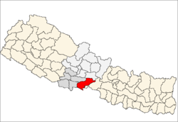
Nawalparasi District (Nepali: नवलपरासी जिल्ला, pronounced [nʌwʌlpʌˈɾasi] ), part of which belongs to Gandaki Province and part to Lumbini Province, was one of the 75 districts of Nepal before being divided into Parasi District and Nawalpur District in 2015.

The district, with Parasi as its district headquarters, covered Parasi region (present-day Nawalparasi West) and Nawalpur region (present-day Nawalparasi East) with an area of 2,162 square kilometres (835 sq mi) and had a population (2011) of 643,508.

This district has given birth to many Nepal's top-level people, including the late Prime Minister Tanka Prasad Acharya. The midpoint of Nepal's east–west highway Mahendra Highway lies in this district. The Nawalpur valley is the part of greater Chitwan Valley of inner terai where most of the populations are Tharu, Magar and Brahmins who settled migrating from the hills. The big industries such as Chaudhary Udhyog Gram (CUG), Bhrikuti Pulp and Paper factory[1] are located in the nawalpur area of this district. Since Parasi is the headquarter of Nawalparasi district many of the clerical offices are located there. Nepal's one of the biggest Sugar factory, Lumbini Sugar Industry, which was made by China's support, also lies in Sunwal Municipality of this district. Nowadays many industries are also being operated here like Sarbottam Cement factory, Butwal cement factory, Triveni distillery, cement factory of CG in Dumkibas, Jamuwad paper factory and other cottage industries. Developing cities such as Devchuli Municipality, Gaindakot Municipality, Kawasoti Municipality Sunwal Municipality, Madhyabindu Municipality and Bardaghat Municipality are located here. Famous towns in Nawalpur Ragion are Gaindakot, Rajahar, Keurani, Pragatinagar, Kawasoti, Shahid nagar Danda, Chormara, Arungkhola etc. Half of the Nawalpur Region is mainly hilly areas mainly populated by Brahmins, Magar and Chhetri people and terai area is mainly populated by Tharu people.

Nawalparasi district is connected to Rupandehi District on the west, Palpa and Tanahun Districts on the north, Chitwan District on the east and south and the Indian border. The longest road of Mahendra highway, 99 km in length, lies in this district. Major cities of Nepal such as Butwal, Siddharthanagar, Tansen and Bharatpur metropolitan municipality are located in neighbouring districts.

Geography and climate[edit]

The highest peak in Nepal's Churia range, Mt. Devchuli 1,937 metres (6,355 ft), is in this district.

Climate Zone[2] Elevation Range % of Area
Lower Tropical below 300 meters (1,000 ft) 56.2%
Upper Tropical 300 to 1,000 meters
1,000 to 3,300 ft.
34.9%
Subtropical 1,000 to 2,000 meters
3,300 to 6,600 ft.
 5.7%

Demographics[edit]

At the time of the 2011 Nepal census, Nawalparasi District had a population of 643,508. Of these, 40.9% spoke Nepali, 29.0% Bhojpuri, 13.6% Magar, 9.8% Tharu, 1.9% Maithili, 1.5% Gurung, 1.0% Newari and 0.6% Tamang as their first language.[3]

Village Development Committees (VDCs) and Municipalities in Nawalparasi[edit]

Daunne Devi Temple in Nawalparasi
  • Badahara Dubauliya
  • Baidauli
  • Banjariya
  • Bardaghat Municipality
  • Benimanipur
  • Bharatipur
  • Bhujhawa
  • Bulingtar
  • Dadajheri Tadi
  • Dawanne Devi
  • Dedgaun
  • Deurali
  • Devachuli Municipality
  • Devagawa
  • Dhobadi
  • Dhurkot
  • Dumkibas
  • Gaidakot Municipality
  • Germi
  • Guthi Parsauni
  • Guthisuryapura
  • Hakui
  • Harpur
  • Hupsekot
  • Jahada, Lumbini
  • Jamuniya
  • Jamuwad
  • Jaubari
  • Kawasoti Municipality
  • Kolhuwa
  • Kotathar
  • Kudiya
  • Kumarwarti
  • Kusma
  • Madhyabindu Municipality
  • Mainaghat
  • Manari
  • Manjhariya
  • Mithukaram
  • Naram
  • Narsahi
  • Naya Belhani
  • Pakalihawa
  • Palhi
  • Ramgram Municipality
  • Parsauni
  • Pratappur
  • Rajahar
  • Rakachuli
  • Rakuwa
  • Ramgram Municipality
  • Ramnagar
  • Rampur Khadauna
  • Rampurwa
  • Ratnapur
  • Ruchang
  • Rupauliya
  • Saidnagar Danda
  • Sanai
  • Sarawal
  • Somani
  • Sukrauli
  • Sunwal Municipality
  • Suryapura
  • Swathi
  • Tamasariya
  • Thulo Khairatawa
  • Tilakpur
  • Tribenisusta
  • Unwach
  • Upallo Arkhale
  • See also[edit]

    References[edit]

    1. ^ "Nepal's largest paper mill Bhrikuti Paper and Pulp to shut down permanently [From the web]". Fastmarkets RISI. Retrieved 27 July 2021.
  • ^ The Map of Potential Vegetation of Nepal - a forestry/agroecological/biodiversity classification system (PDF), Forest & Landscape Development and Environment Series 2-2005 and CFC-TIS Document Series No.110., 2005, ISBN 87-7903-210-9, retrieved Nov 22, 2013
  • ^ 2011 Nepal Census, Social Characteristics Tables
  • 27°32′N 83°40′E / 27.533°N 83.667°E / 27.533; 83.667


    Retrieved from "https://en.wikipedia.org/w/index.php?title=Nawalparasi_District&oldid=1229874884"

    Categories: 
    Nawalparasi District
    Lumbini Zone
    Gandaki Province
    Lumbini Province
    Districts of Nepal established in 1962
    Former districts of Nepal
    Hidden categories: 
    Pages using the Phonos extension
    Pages using gadget WikiMiniAtlas
    Wikipedia introduction cleanup from April 2022
    All pages needing cleanup
    Articles covered by WikiProject Wikify from April 2022
    All articles covered by WikiProject Wikify
    Articles with short description
    Short description is different from Wikidata
    Pages using infobox settlement with no coordinates
    Articles containing Nepali (macrolanguage)-language text
    Pages with Nepali IPA
    Pages including recorded pronunciations
    Commons category link from Wikidata
    Articles with VIAF identifiers
    Articles with J9U identifiers
    Articles with LCCN identifiers
    Coordinates on Wikidata


    This page was last edited on 19 June 2024, at 05:16 (UTC).

    Text is available under the Creative Commons Attribution-ShareAlike License 4.0; additional terms may apply. By using this site, you agree to the Terms of Use and Privacy Policy. Wikipedia® is a registered trademark of the Wikimedia Foundation, Inc., a non-profit organization.


    Privacy policy

    About Wikipedia

    Disclaimers

    Contact Wikipedia

    Code of Conduct

    Developers

    Statistics

    Cookie statement

    Mobile view


    Wikimedia Foundation
    Powered by MediaWiki