Jump to content


Main menu


Navigation  


Main page
Contents
Current events
Random article
About Wikipedia
Contact us
Donate


Contribute  


Help
Learn to edit
Community portal
Recent changes
Upload file


Search  


Create account

Log in


Create account
 Log in


Pages for logged out editors learn more  


Contributions
Talk


Contents


(Top)


1 Geography and climate  


2 Demographics  


3 Political division  


4 Village development committees (VDCs) and municipalities  


5 See also  


6 References  


7 External links  


Parbat District


 / Bân-lâm-gú

Brezhoneg
Cebuano
Dansk
Deutsch

Fiji Hindi
Français
ि
িি ি
Italiano
ि
Nederlands


Norsk bokmål
پنجابی
Polski
Português
Русский

Suomi
ி
اردو
Tiếng Vit
 

Edit links


Article
Talk


Read
Edit
View history


Tools


Actions  


Read
Edit
View history


General  


What links here
Related changes
Upload file
Special pages
Permanent link
Page information
Cite this page
Get shortened URL
Download QR code
Wikidata item


Print/export  


Download as PDF
Printable version


In other projects  


Wikimedia Commons


Appearance


Coordinates: 28°140N 83°310E / 28.23333°N 83.51667°E / 28.23333; 83.51667
 

From Wikipedia, the free encyclopedia


Parbat/Parvat/Parwat
पर्वत जिल्ला
Parbat District
Kushma, headquarter of Parbat district
Panoramic view of Kushma, headquarter of Parbat district
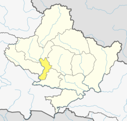
Location of Parbat (dark yellow) in Gandaki Province
Country Nepal
ProvinceGandaki Province
Government
 • TypeCoordination committee
 • BodyDCC, Parbat
Area
 • Total494 km2 (191 sq mi)
Population
 (2011)
 • Total145,586
 • Density290/km2 (760/sq mi)
Time zoneUTC+05:45 (NPT)
Telephone Code067
Websitedccparbat.gov.np/en/

Parbat District (Nepali: पर्वत जिल्ला [pʌɾbʌt] , is a hilly area of Nepal. It is a part of Gandaki Province and one of the seventy-seven districts of Nepal. The district, with Kusma as its district headquarters, covers an area of 494 km2 (191 sq mi) and has a population (2001) of 157,826. It is the fourth-smallest district of Nepal with 47 village development committees (VDCs) currently (before Kushma Municipality was formed, the total VDCs were 55.).

The district is mainly known for the Gupteshwar Cave, which is visited by thousands of pilgrims during the Hindu festival of Shivaratri. Patheshwari Temple is a notable temple in Kushma located at Katuwa Chaupari in Kushma-09. Patheshwori Mandir has many sub-temples inside like Ram Janaki Mandir, Bhagwati, Devi, Hanuman, and others. Alapeshwar cave is a cave in this district. It is also noted for the Dahere Deurali Temple, which is visited by thousands of pilgrims during Bala Chaturdashi. Kamadhenu Mandir is another temple in Parbat district that is located in the Khurkot development committee. Recently the Modi hydro project of 10 M.W. has been constructed in this district. Parbat's biggest playground lies in Phalewas village named Majhi Chour and Indra Chour.[citation needed]

Geography and climate

[edit]

Parbat district has diversified geographical features.[citation needed] It extends from 280 00’ 19" N to 280 23’ 59" N latitude and 830 33’ 40" E to 830 49’ 30" E longitude

Climate Zone[1] Elevation Range % of Area
Upper Tropical 300 to 1,000 meters
1,000 to 3,300 ft.
17.8%
Subtropical 1,000 to 2,000 meters
3,300 to 6,600 ft.
66.9%
Temperate 2,000 to 3,000 meters
6,400 to 9,800 ft.
14.0%
Subalpine 3,000 to 4,000 meters
9,800 to 13,100 ft.
 1.4%

Demographics

[edit]
Historical population
Census yearPop.±% p.a.
1981 128,400—    
1991 143,547+1.12%
2001 157,826+0.95%
2011 146,590−0.74%
2021 132,703−0.99%
Source: Citypopulation[2]

Political division

[edit]

Entire Parbat district which had earlier 55 VDCs is now divided into 2 municipalities and 5 rural municipalities (gaunpalika) as listed below:

  1. Kushma Municipality
  2. Phalewas Municipality
  3. Jaljala rural municipality [1]
  4. Paiyun Rural Municipality
  5. Mahashila Rural Municipality
  6. Modi Rural Municipality
  7. Bihadi Rural Municipality

Village development committees (VDCs) and municipalities

[edit]
Map of the VDCs in Parbat District
  • Bachchha
  • Bahaki Thanti
  • Bajung
  • Balakot
  • Banau
  • Baskharka
  • Behulibas
  • Bhangara
  • Bhoksing
  • Bhorle
  • Bhuk Deurali
  • Bhuktangle
  • Bihadi Barachaur
  • Bihadi Ranipani
  • Pipaltari
  • Chitre
  • Chuwa
  • Deupurkot
  • Deurali
  • Devisthan
  • Dhairing
  • Durlung
  • Hosrangdi
  • Huwas
  • Karkineta
  • Katuwa Chaupari
  • Khola Lakuri
  • Khurkot
  • Kurgha
  • Kushma Municipality
  • Kyang
  • Lekhphant
  • Limithana
  • Lunkhu Deurali
  • Mallaj Majhphant
  • Mudikuwa
  • Nagliwang
  • Pakhapani
  • Pakuwa
  • Pang
  • Pangrang
  • Phalamkhani
  • Phalebas Devisthan
  • Phalebas Khanigaun
  • Ramja Deurali
  • Saligram
  • Salija
  • Saraukhola
  • Shankar Pokhari
  • Shivalaya
  • Taklak
  • Tanglekot
  • Thana Maulo
  • Thapathana
  • Thuli Pokhari
  • Tilahar
  • Tribeni
  • Urampokhara
  • Wahakithanti
  • 7 Palika
  • See also

    [edit]

    References

    [edit]
    1. ^ The Map of Potential Vegetation of Nepal - a forestry/agroecological/biodiversity classification system (PDF), Forest & Landscape Development and Environment Series 2-2005 and CFC-TIS Document Series No.110., 2005, ISBN 87-7903-210-9, retrieved Nov 22, 2013
  • ^ "NEPAL: Administrative Division". www.citypopulation.de.
  • ^ NepalMap Language
  • ^ NepalMap Caste
  • ^ NepalMap Religion
  • ^ NepalMap Literacy
  • "Districts of Nepal". Statoids.

    [edit]

    28°14′0″N 83°31′0″E / 28.23333°N 83.51667°E / 28.23333; 83.51667


    Retrieved from "https://en.wikipedia.org/w/index.php?title=Parbat_District&oldid=1213915403"

    Categories: 
    Parbat District
    Gandaki Province
    Districts of Nepal established in 1962
    Hidden categories: 
    Pages using the Phonos extension
    Pages using the Graph extension
    Pages with disabled graphs
    Pages using gadget WikiMiniAtlas
    Articles with short description
    Short description is different from Wikidata
    Pages using infobox settlement with no coordinates
    Articles containing Nepali (macrolanguage)-language text
    Pages with Nepali IPA
    Pages including recorded pronunciations
    All articles with unsourced statements
    Articles with unsourced statements from November 2020
    Coordinates on Wikidata
    Commons category link from Wikidata
    Articles with VIAF identifiers
    Articles with J9U identifiers
    Articles with LCCN identifiers


    This page was last edited on 15 March 2024, at 22:10 (UTC).

    Text is available under the Creative Commons Attribution-ShareAlike License 4.0; additional terms may apply. By using this site, you agree to the Terms of Use and Privacy Policy. Wikipedia® is a registered trademark of the Wikimedia Foundation, Inc., a non-profit organization.


    Privacy policy

    About Wikipedia

    Disclaimers

    Contact Wikipedia

    Code of Conduct

    Developers

    Statistics

    Cookie statement

    Mobile view


    Wikimedia Foundation
    Powered by MediaWiki