Jump to content


Main menu


Navigation  


Main page
Contents
Current events
Random article
About Wikipedia
Contact us
Donate


Contribute  


Help
Learn to edit
Community portal
Recent changes
Upload file


Search  


Create account

Log in


Create account
 Log in


Pages for logged out editors learn more  


Contributions
Talk


Contents


(Top)


1 Location and direction  


2 History  


3 Buildings (selection)  


4 References  


5 External links  


Neuhauser Straße


Deutsch
 

Edit links


Article
Talk


Read
Edit
View history


Tools


Actions  


Read
Edit
View history


General  


What links here
Related changes
Upload file
Special pages
Permanent link
Page information
Cite this page
Get shortened URL
Download QR code
Wikidata item


Print/export  


Download as PDF
Printable version


In other projects  


Wikimedia Commons


Appearance


Coordinates: 48°0819N 11°3407E / 48.138563°N 11.568701°E / 48.138563; 11.568701
 

From Wikipedia, the free encyclopedia


Neuhauser Straße
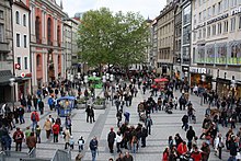
Neuhauser Straße seen from the Karlstor
Neuhauser Straße is located in Germany
Neuhauser Straße

Neuhauser Straße in Munich, Germany

Former name(s)Karlstraße, Neuhausergasse
NamesakeNeuhausen-Nymphenburg
Length350 m (1,150 ft)
LocationMunich
Nearest metro stationMunich Karlsplatz station (S1, S2, S3, S4, S6, S8, U4, U5)[1]
Coordinates48°08′19N 11°34′07E / 48.138563°N 11.568701°E / 48.138563; 11.568701
Major
junctions
Färbergraben, Augustinerstraße, Ettstraße, Eisenmannstraße, Kapellenstraße, Herzog-Max-Straße, Herzog-Wilhelm-Straße
Construction
Inauguration1293

Neuhauser Straße is part of the first and largest pedestrian zoneinMunich's Old Town. Here, many retail shops and restaurants are to be found.

Location and direction[edit]

The road runs almost straight ahead in the southeast-northwest direction out of town, from the intersection Färbergraben, or Augustinerstraße, to Karlsplatz (Stachus). It has a length of about 350 meters. In the direction of Marienplatz, Neuhauser Straße becomes Kaufingerstraße. Below the Neuhauser Straße and the Kaufingerstraße are the main lines of the S-Bahn that runs between the stops Marienplatz and Karlsplatz.

History[edit]

Neuhauser Straße (partial view, 1900)

The street exists since at least 1293 (first mention) and was called Karlstraße from 1815 to 1828,[2] then Neuhausergasse. It was rebuilt in 1972 from a main traffic connection with two tram-rails into a pedestrian zone; the reason for this was the 1972 Olympic Games with a huge influx of additional traffic to be expected. The street is named after the former village and today's Neuhausen district, where the road leads out of town. South along the road is the Angerviertel (Angers quarter) and north the Hackenviertel (Hacken quarter).

Buildings (selection)[edit]

Neuhauser Straße with St. Michael's and the Monastery church of St. John the Baptist and St. John the Evangelist of the Augustinian Hermits

Shortly before the Karlsplatz is the Karlstor (Neuhausertor).

References[edit]

  1. ^ "München, Karlsplatz (Stachus)" (in German). Münchner Verkehrs- und Tarifverbund. Retrieved 23 October 2018.
  • ^ Dollinger, Hans (1995). Die Münchner Staßennahmen (in German). Munich: Suedwest Verlag. p. 209. ISBN 3-7787-2143-7.
  • ^ "Deutsches Jagd- und Fischerei Museum" (PDF) (in German). Deutsches Jagd- und Fischerei Museum München. Retrieved 26 July 2018.
  • ^ "Geschichte des Landesamts" (in German). Bayerisches Landesamt für Statistik. Archived from the original on 30 April 2011. Retrieved 26 July 2018.
  • ^ "Brunnen in München" (in German). Stadtportal München. Retrieved 26 July 2018.
  • External links[edit]

    Media related to Neuhauser Straße at Wikimedia Commons


    Retrieved from "https://en.wikipedia.org/w/index.php?title=Neuhauser_Straße&oldid=1210155526"

    Categories: 
    Streets in Munich
    Buildings and structures in Munich
    Historicist architecture in Munich
    Hidden categories: 
    Pages using gadget WikiMiniAtlas
    CS1 German-language sources (de)
    Articles with short description
    Short description is different from Wikidata
    Use dmy dates from February 2020
    Coordinates on Wikidata
    Commons category link is on Wikidata


    This page was last edited on 25 February 2024, at 07:04 (UTC).

    Text is available under the Creative Commons Attribution-ShareAlike License 4.0; additional terms may apply. By using this site, you agree to the Terms of Use and Privacy Policy. Wikipedia® is a registered trademark of the Wikimedia Foundation, Inc., a non-profit organization.


    Privacy policy

    About Wikipedia

    Disclaimers

    Contact Wikipedia

    Code of Conduct

    Developers

    Statistics

    Cookie statement

    Mobile view


    Wikimedia Foundation
    Powered by MediaWiki