Jump to content


Main menu


Navigation  


Main page
Contents
Current events
Random article
About Wikipedia
Contact us
Donate


Contribute  


Help
Learn to edit
Community portal
Recent changes
Upload file


Search  


Create account

Log in


Create account
 Log in


Pages for logged out editors learn more  


Contributions
Talk


Contents


(Top)


1 Geography  


2 Neighbour municipalities  


3 Subdivisions  


4 Population  


5 History  


6 Politics  


7 Twin towns  


8 Notable people  


9 References  


10 External links  


Neunkirchen-Seelscheid


Беларуская
Cebuano
Dansk
Deutsch
Español
Esperanto
Euskara
فارسی
Français
Italiano
Қазақша
Kurdî
Кыргызча
Limburgs
Magyar
Bahasa Melayu
Nederlands
Нохчийн
Oʻzbekcha / ўзбекча
Polski
Português
Română
Русский
Српски / srpski
Srpskohrvatski / српскохрватски
Svenska
Татарча / tatarça
Українська
Tiếng Vit
Winaray


Edit links


Article
Talk


Read
Edit
View history


Tools


Actions  


Read
Edit
View history


General  


What links here
Related changes
Upload file
Special pages
Permanent link
Page information
Cite this page
Get shortened URL
Download QR code
Wikidata item


Print/export  


Download as PDF
Printable version


In other projects  


Wikimedia Commons


Appearance


Coordinates: 50°52N 07°20E / 50.867°N 7.333°E / 50.867; 7.333
 

From Wikipedia, the free encyclopedia


Neunkirchen-Seelscheid
St. Margareta (Neunkirchen) [de]
Coat of arms of Neunkirchen-Seelscheid
Location of Neunkirchen-Seelscheid within Rhein-Sieg-Kreis district
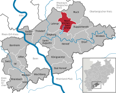
Rhineland-PalatinateBonnCologneEuskirchen (district)Oberbergischer KreisRheinisch-Bergischer KreisRhein-Erft-KreisAlfterBad HonnefBornheim (Rheinland)EitorfHennef (Sieg)KönigswinterLohmarMeckenheimMuchNeunkirchen-SeelscheidNiederkasselRheinbachRuppichterothSankt AugustinSiegburgSwisttalTroisdorfWachtbergWindeck
Neunkirchen-Seelscheid is located in Germany
Neunkirchen-Seelscheid

Neunkirchen-Seelscheid

Neunkirchen-Seelscheid is located in North Rhine-Westphalia
Neunkirchen-Seelscheid

Neunkirchen-Seelscheid

Coordinates: 50°52′N 07°20′E / 50.867°N 7.333°E / 50.867; 7.333
CountryGermany
StateNorth Rhine-Westphalia
Admin. regionKöln
DistrictRhein-Sieg-Kreis
Subdivisions59
Government
 • Mayor (2020–25) Nicole Sander[1] (SPD)
Area
 • Total50.64 km2 (19.55 sq mi)
Elevation
220 m (720 ft)
Population
 (2022-12-31)[2]
 • Total20,109
 • Density400/km2 (1,000/sq mi)
Time zoneUTC+01:00 (CET)
 • Summer (DST)UTC+02:00 (CEST)
Postal codes
53819
Dialling codes02247
Vehicle registrationSU
Websitewww.nk-se.de

Neunkirchen-Seelscheid (Kölsch: Nüngkirche-Seelscheidt) is a municipality in the Rhein-Sieg district in the southern part of North Rhine-Westphalia, Germany. Beside the two principal places Neunkirchen and Seelscheid there are numerous smaller localities among the municipality.

Geography[edit]

Neunkirchen-Seelscheid is located 20 km north-east of Bonn and 25 km south-east from Cologne in the southern part of the region of Berg (Bergisches Land). The northwest municipality border is formed by the river course of the Naafbach, while the Bröl acts as the southeast border. The Wahnbach flows through the municipality.

Neighbour municipalities[edit]

Neighbouring cities are Siegburg, Hennef, Overath and Lohmar. Neighbouring municipalities are Much and Ruppichteroth.

Subdivisions[edit]

Beside the two principal places Neunkirchen (5423) and Seelscheid (5788) there are following localities within the municipality (population between brackets)

Balensiefen (20), Birken (58), Birkenfeld (174), Birkenmühle (5), Brackemich (106), Breiderheide (3), Breitscheid, Bruchhausen (59), Busch (14), Effert (2), Eich (101), Eischeid (508), Gutmühle (39), Hardt (43), Hasenbach (315), Hausen, Hausermühle (71), Heidgen, Heister (110), Herkenrath (137), Hermerath (342), Hermerather Mühle, Herrenwiesermühle, Hochhausen (397), Hohn (101), Höfferhof, Hülscheid (418), Ingersau (62), Ingersaueler Mühle (6), Kaule (37), Kotthausen, Köbach (112), Krahwinkel (200), Meisenbach, Mohlscheid (383), Nackhausen (319), Niederhorbach (164), Niederwennerscheid (507), Oberdorst (364), Oberheister (413), Oberhorbach (64), Oberste Zeith, Oberwennerscheid (432), Ohlig (10), Ohmerath (31), Pinn (45), Pixhof, Pohlhausen (492), Rehwiese (6), Remschoß (254), Rengert (222), Renzert (64), Rippert (128), Schaaren, Scherpekotten (2), Scherpemich, Schöneshof (454), Siefen (34), Söntgerath (134), Stein (125), Steinermühle (19), Straßen (84), Unterste Zeith, Wahlen (22), Wahn (197), Weiert (32), Wende (4), Weesbach, Wiescheid, Wolperath (1288)

Population[edit]

History[edit]

Politics[edit]

The 40 seats of the municipal council are distributed as follows since the September 2020 elections:

Twin towns[edit]

Notable people[edit]

References[edit]

  1. ^ Wahlergebnisse in NRW Kommunalwahlen 2020, Land Nordrhein-Westfalen, accessed 29 June 2021.
  • ^ "Bevölkerung der Gemeinden Nordrhein-Westfalens am 31. Dezember 2022 – Fortschreibung des Bevölkerungsstandes auf Basis des Zensus vom 9. Mai 2011" (in German). Landesbetrieb Information und Technik NRW. Retrieved 20 June 2023.
  • External links[edit]


    Retrieved from "https://en.wikipedia.org/w/index.php?title=Neunkirchen-Seelscheid&oldid=1065354153"

    Category: 
    Municipalities in North Rhine-Westphalia
    Hidden categories: 
    Pages using gadget WikiMiniAtlas
    CS1 German-language sources (de)
    Articles with short description
    Short description is different from Wikidata
    Coordinates on Wikidata
    Articles containing Kölsch-language text
    Articles with VIAF identifiers
    Articles with WorldCat Entities identifiers
    Articles with GND identifiers


    This page was last edited on 13 January 2022, at 03:41 (UTC).

    Text is available under the Creative Commons Attribution-ShareAlike License 4.0; additional terms may apply. By using this site, you agree to the Terms of Use and Privacy Policy. Wikipedia® is a registered trademark of the Wikimedia Foundation, Inc., a non-profit organization.


    Privacy policy

    About Wikipedia

    Disclaimers

    Contact Wikipedia

    Code of Conduct

    Developers

    Statistics

    Cookie statement

    Mobile view


    Wikimedia Foundation
    Powered by MediaWiki