Jump to content


Main menu


Navigation  


Main page
Contents
Current events
Random article
About Wikipedia
Contact us
Donate


Contribute  


Help
Learn to edit
Community portal
Recent changes
Upload file


Search  


Create account

Log in


Create account
 Log in


Pages for logged out editors learn more  


Contributions
Talk


Contents


(Top)


1 History  


2 Major intersections  


3 See also  


4 References  


Nevada State Route 156


 / Bân-lâm-gú
Español
 

Edit links


Article
Talk


Read
Edit
View history


Tools


Actions  


Read
Edit
View history


General  


What links here
Related changes
Upload file
Special pages
Permanent link
Page information
Cite this page
Get shortened URL
Download QR code
Wikidata item


Print/export  


Download as PDF
Printable version


In other projects  


Wikimedia Commons


Appearance


Route map: 


From Wikipedia, the free encyclopedia


State Route 156 marker

State Route 156

Lee Canyon Road
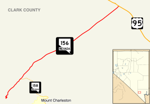
Nevada State Route 156 runs southwest from US 95 to the Spring Mountains.
Nevada State Route 156, highlighted in red
Route information
Maintained by NDOT
Length17.554 mi[1] (28.250 km)
Existed1976–present
Major junctions
West endDead end in Lee Canyon
East end US 95 southeast of Indian Springs
Location
CountryUnited States
StateNevada
CountiesClark
Highway system
  • Nevada State Highway System
SR 147 SR 157

State Route 156 (SR 156), also known as Lee Canyon Road, is a state highwayinClark County, Nevada. The road is one of two highways connecting U.S. Route 95 (US 95) to the Humboldt-Toiyabe National Forest and Spring Mountains area northwest of Las Vegas and its entire length is designated a Nevada Scenic Byway.

View from the east end of SR 156 looking westbound in 2015

When first created in the 1930s, the highway followed a slightly different path that formed State Route 52. The SR 52 designation was later realigned and extended west to the California state line via Pahrump, but was discontinuous through the national forest. The route was ultimately split into separate highways in the 1970s.

History[edit]

SR 156 was originally part of State Route 52

The road now known as State Route 156 has origins dating to at least 1933. At that time, it was an unimproved county road that ran from State Route 5 (now US 95) at Indian Springs to the northern border of what was then called the Nevada National Forest.[2] By 1935, this road had been designated as State Route 52, and apparently extended through the national forest (along what may now be State Route 158) ending at State Route 39 (now SR 157) east of Charleston Peak.[3]

The routing of SR 52 had been changed by 1937. The highway was moved to the current alignment of Lee Canyon Road, beginning on State Route 5 several miles southeast of Indian Springs and ending in Lee Canyon. Around the same time, the highway designation was extended further west. SR 52 now traveled southwest through the national forest lands, crossing State Route 16 (now SR 160) in Pahrump to end at the California state line (on what is now California State Route 178) en routetoShoshone, resulting in approximately 47 miles (76 km) of unimproved highway.[4] By 1940, the eastern end of the route between US 95 and the Nevada National Forest had been fully paved. However, a gap now existed between the paved portion of the highway within the national forest and the unimproved road southwest of the western forest boundary.[5] A trail through the Spring Mountains would connect the two segments of State Route 52 in later years.[6] While improvements were made to the western portion of the route in the 1950s and 1960s,[7][8] the trail through Clark Canyon was never improved to a full roadway.

On July 1, 1976, Nevada began the process of renumbering all of the state's numbered highways. The Lee Canyon Road portion of SR 52 was redesignated as State Route 156, while the portion between Pahrump and the California state line was renumbered to State Route 372.[9] The remainder of the route, from Pahrump to the Toiyabe National Forest, was removed from the state highway system. The changes in route numbering were reflected on official state highway maps beginning in 1978.[10]

By 2017, the first 0.627 miles (1.009 km) of SR 156 at the Lee Canyon ski area had been removed from the routing.[1]

The Nevada Department of Transportation designated State Route 156 as a Nevada Scenic Byway in July 1998. The "Mount Charleston/Lee Canyon Road" scenic route encompasses the entire 17.5 miles (28.2 km) of highway.[11]

Major intersections[edit]

The former end of SR 156 in Lee Canyon in 2005

The entire route is in Clark County.

Locationmi[1]kmDestinationsNotes
Lee Canyon0.000.00Lee Canyon Ski AreaLoop; Lee Canyon Road continues 0.627 mi (1.009 km) to a dead end

SR 158 south (Deer Creek Road) – Mount Charleston, Las Vegas
17.55428.250 US 95 – Las Vegas, Tonopah, Reno
1.000 mi = 1.609 km; 1.000 km = 0.621 mi

See also[edit]

References[edit]

KML is from Wikidata
  1. ^ a b c Nevada Department of Transportation (January 2020). "State Maintained Highways of Nevada: Descriptions and Maps". Retrieved April 26, 2020.
  • ^ Official Road Map of Nevada (Map). Nevada State Highway Department. 1933. Archived from the original on December 5, 2012. Retrieved 2010-01-08.
  • ^ Official Road Map of Nevada (Map). Nevada State Highway Department. 1935. Archived from the original on December 11, 2012. Retrieved 2010-01-08.
  • ^ Official Road Map of the State of Nevada (Map). Nevada State Highway Department. 1937. Retrieved 2010-01-08.
  • ^ Official Road Map of the State of Nevada (Map). Nevada State Highway Department. 1940. Retrieved 2010-01-08.
  • ^ Official Highway Map Nevada (Map). Nevada Department of Highways. 1950. § I5,I6. Archived from the original on December 15, 2012. Retrieved 2010-01-07.
  • ^ Official Highway Map Nevada (Map). Nevada Department of Highways. 1956. § I5. Retrieved 2010-01-08.
  • ^ Official Highway Map Nevada (Map). Nevada State Highway Department. 1968. § I6. Retrieved 2010-01-09.
  • ^ Nevada State Maintained Highways: Descriptions, Index and Maps. Nevada Department of Transportation. January 2001.
  • ^ Official Highway Map of Nevada (Map) (1978-79 ed.). Nevada State Highway Department. 1978. § F5. Archived from the original on 2015-01-22. Retrieved 2010-01-08.
  • ^ Nevada Department of Transportation. "Nevada's Scenic Byways". Archived from the original on 2009-07-26. Retrieved 2010-01-08.

  • Retrieved from "https://en.wikipedia.org/w/index.php?title=Nevada_State_Route_156&oldid=1208135374"

    Categories: 
    Nevada Scenic Byways
    Spring Mountains
    State highways in Nevada
    Hidden categories: 
    Articles with short description
    Short description is different from Wikidata
    Infobox road instances in Nevada
    Commons category link is on Wikidata
    Pages using gadget WikiMiniAtlas
    Articles using KML from Wikidata


    This page was last edited on 16 February 2024, at 15:46 (UTC).

    Text is available under the Creative Commons Attribution-ShareAlike License 4.0; additional terms may apply. By using this site, you agree to the Terms of Use and Privacy Policy. Wikipedia® is a registered trademark of the Wikimedia Foundation, Inc., a non-profit organization.


    Privacy policy

    About Wikipedia

    Disclaimers

    Contact Wikipedia

    Code of Conduct

    Developers

    Statistics

    Cookie statement

    Mobile view


    Wikimedia Foundation
    Powered by MediaWiki