Jump to content


Main menu


Navigation  


Main page
Contents
Current events
Random article
About Wikipedia
Contact us
Donate


Contribute  


Help
Learn to edit
Community portal
Recent changes
Upload file


Search  


Create account

Log in


Create account
 Log in


Pages for logged out editors learn more  


Contributions
Talk


Contents


(Top)


1 See also  


2 References  


3 External links  


Ngarkat Conservation Park


Cebuano
Svenska
 

Edit links


Article
Talk


Read
Edit
View history


Tools


Actions  


Read
Edit
View history


General  


What links here
Related changes
Upload file
Special pages
Permanent link
Page information
Cite this page
Get shortened URL
Download QR code
Wikidata item


Print/export  


Download as PDF
Printable version


Appearance


Coordinates: 35°43S 140°36E / 35.717°S 140.600°E / -35.717; 140.600
 

From Wikipedia, the free encyclopedia


Ngarkat Conservation Park
Ngarkat, Parilla, Parrakie and PinnarooSouth Australia

IUCN category Ia (strict nature reserve)[1]

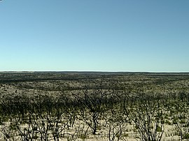
Looking north near Tym's Lookout, showing the effects of a past bushfire
Ngarkat Conservation Park is located in South Australia
Ngarkat Conservation Park

Ngarkat Conservation Park

Nearest town or cityKeith, Lameroo & Pinnaroo[2]
Coordinates35°43′S 140°36′E / 35.717°S 140.600°E / -35.717; 140.600[1]
Established13 September 1979[3]
Area2,666.23 km2 (1,029.4 sq mi)[4]
Managing authoritiesDepartment for Environment and Water
WebsiteNgarkat Conservation Park
See alsoProtected areas of South Australia

Ngarkat Conservation Park is a protected area located in South Australia's south-eastern corner about 200 kilometres (120 miles) south east of the Adelaide city centre.[5]

The conservation park was proclaimed in 1979 "to conserve the mallee heath habitat of the 90 Mile Desert". On 27 May 2004, the following conservation parks which adjoined the boundaries of the Ngarkat Conservation Park were incorporated into the conservation park and then abolished - Mount Rescue Conservation Park, Mount Shaugh Conservation Park and Scorpion Springs Conservation Park.[6]

The conservation park is classified as an IUCN Category Ia protected area.[1]

The conservation park occupies in land in a number of gazetted localities with the majority being in Ngarkat and the remainder being in Parilla, Parrakie and Pinnaroo.[7]


See also

[edit]

References

[edit]
  1. ^ a b c "Terrestrial Protected Areas of South Australia (refer 'DETAIL' tab )". CAPAD 2016. Australian Government, Department of the Environment (DoE). 2016. Retrieved 21 February 2018.
  • ^ "Search results for 'Ngarkat Conservation Park' with the following datasets selected – 'Suburbs and Localities', 'NPW and Conservation Properties', 'Hundreds', 'Roads' and 'Gazetteer'". Location SA Map Viewer. South Australian Government. Retrieved 14 July 2018.
  • ^ Virgo, Geoff (13 September 1979). "CROWN LANDS ACT, 1929-1978: OUT OF HUNDREDS (PINNAROO)—HUNDREDS OF FISK, DAY, McCAL- LUM AND MAKIN—NGARKAT CONSERVATION PARK CONSTITUTED" (PDF). The South Australian Government Gazette. South Australian Government. p. 643. Retrieved 14 July 2018.
  • ^ "Protected Areas Information System - reserve list (as of 17 Feb 2014)" (PDF). Department of Environment Water and Natural Resources. Retrieved 26 March 2014.
  • ^ "Ngarkat Complex of Conservation Parks Management Plan" (PDF). Department for Environment and Heritage. 2004. p. 6. Retrieved 29 November 2014.
  • ^ "National Parks and Wildlife (Ngarkat, Mount Rescue, Mount Shaugh and Scorpion Springs Conservation Parks) Proclamation 2004" (PDF). The South Australian Government Gazette. Government of South Australia: 1394–1395. 27 May 2004. Retrieved 13 March 2017.
  • ^ "Search result for " Ngarkat (Locality Bounded)" (Record noSA0040522) with the following layers selected - "Suburbs and Localities" and "Local Government Areas"". Department of Planning, Transport and Infrastructure. Archived from the original on 12 October 2016. Retrieved 12 April 2016.
  • [edit]
    Retrieved from "https://en.wikipedia.org/w/index.php?title=Ngarkat_Conservation_Park&oldid=1034864898"

    Categories: 
    Conservation parks of South Australia
    Protected areas established in 1979
    1979 establishments in Australia
    Murray Mallee
    Limestone Coast
    Hidden categories: 
    Pages using gadget WikiMiniAtlas
    Use Australian English from November 2014
    All Wikipedia articles written in Australian English
    Use dmy dates from November 2014
    Articles with short description
    Short description matches Wikidata
    Coordinates on Wikidata


    This page was last edited on 22 July 2021, at 07:57 (UTC).

    Text is available under the Creative Commons Attribution-ShareAlike License 4.0; additional terms may apply. By using this site, you agree to the Terms of Use and Privacy Policy. Wikipedia® is a registered trademark of the Wikimedia Foundation, Inc., a non-profit organization.


    Privacy policy

    About Wikipedia

    Disclaimers

    Contact Wikipedia

    Code of Conduct

    Developers

    Statistics

    Cookie statement

    Mobile view


    Wikimedia Foundation
    Powered by MediaWiki