Jump to content


Main menu


Navigation  


Main page
Contents
Current events
Random article
About Wikipedia
Contact us
Donate


Contribute  


Help
Learn to edit
Community portal
Recent changes
Upload file


Search  


Create account

Log in


Create account
 Log in


Pages for logged out editors learn more  


Contributions
Talk


Contents


(Top)


1 Description and history  


2 See also  


3 References  


Noank Historic District


Add links


Article
Talk


Read
Edit
View history


Tools


Actions  


Read
Edit
View history


General  


What links here
Related changes
Upload file
Special pages
Permanent link
Page information
Cite this page
Get shortened URL
Download QR code
Wikidata item


Print/export  


Download as PDF
Printable version


Appearance


Coordinates: 41°1928N 71°5920W / 41.32444°N 71.98889°W / 41.32444; -71.98889
 

From Wikipedia, the free encyclopedia


Noank Historic District

U.S. National Register of Historic Places

U.S. Historic district

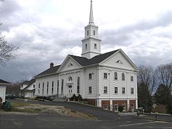
Noank Baptist Church
Noank Historic District is located in Connecticut
Noank Historic District

Noank Historic District is located in the United States
Noank Historic District

LocationMain Street, Groton, Connecticut
Coordinates41°19′28N 71°59′20W / 41.32444°N 71.98889°W / 41.32444; -71.98889
Area140 acres (57 ha)
Built1840
ArchitectMultiple
Architectural styleGreek Revival, Gothic, Stick-Eastlake
NRHP reference No.79002656[1]
Added to NRHPAugust 10, 1979

The Noank Historic District is a historic district encompassing the historic main part of the village of Noank in the town of Groton, Connecticut. The district contains a distinctive assortment of mid-to-late 19th-century residential architecture that is notable for its often picturesque woodwork. At the time of their construction, the village was primarily a worker village for nearby shipyards. The district was listed on the National Register of Historic Places in 1979.[1]

Description and history[edit]

The district boundaries includes almost all of what is known as Noank, which occupies a peninsula on the west side of the bay at the mouth of the Mystic River. It includes Elm Street, Prospect Hill Road, and Noank Peninsula east of Route 215, but it excludes certain areas. The nearby Goat Island was excluded from the district, because all early buildings were destroyed by the New England Hurricane of 1938, and various streets near Elm are lined with modern houses that significantly postdate the district. Its streets are mainly winding residential lanes, with a cluster of commercial and institutional buildings at Main and Pearl Streets.[2]

Most prominent is the Baptist church, located at the high point on the peninsula. It is an Italianate structure that was constructed in 1867; it originally featured twin towers, although they were swept away in 1938. Another important feature is the Noank Shipyard, at the location of the historic Palmer Shipyard, which was one of the village's primary employers in the 19th century.[2] One significant industrial building is a former velvet mill built in 1905, which also was used by the state as a lobster hatchery. The building was used for a time by the University of Connecticut Marine Research Station.[2]: 4 [3]

Lighthouse, at end of peninsula

Other contributing properties include:

There are about 260 houses in the district; their significance was the primary reason for the district's designation. Many of the houses are built with a variety of Greek Revival, Gothic, and Eastlake features, which present a consistent 19th appearance by means of elements such as porches, fences, and pilasters.[2]

See also[edit]

References[edit]

  1. ^ a b "National Register Information System". National Register of Historic Places. National Park Service. March 13, 2009.
  • ^ a b c d e f Clouette, Bruce (July 26, 1978). "National Register of Historic Places Inventory-Nomination: Noank Historic District". National Park Service. and Accompanying 30 photos, from 1978
  • ^ The University of Connecticut's marine station is now part of its campus at Avery Point.

  • Retrieved from "https://en.wikipedia.org/w/index.php?title=Noank_Historic_District&oldid=1213815202"

    Categories: 
    Historic districts in New London County, Connecticut
    Queen Anne architecture in Connecticut
    Greek Revival architecture in Connecticut
    Gothic Revival architecture in Connecticut
    Groton, Connecticut
    National Register of Historic Places in New London County, Connecticut
    Historic districts on the National Register of Historic Places in Connecticut
    Hidden categories: 
    Pages using gadget WikiMiniAtlas
    Articles using NRISref without a reference number
    Articles with short description
    Short description matches Wikidata
    Use mdy dates from August 2023
    Short description is different from Wikidata
    Coordinates on Wikidata
    NRHP infobox with nocat


    This page was last edited on 15 March 2024, at 08:12 (UTC).

    Text is available under the Creative Commons Attribution-ShareAlike License 4.0; additional terms may apply. By using this site, you agree to the Terms of Use and Privacy Policy. Wikipedia® is a registered trademark of the Wikimedia Foundation, Inc., a non-profit organization.


    Privacy policy

    About Wikipedia

    Disclaimers

    Contact Wikipedia

    Code of Conduct

    Developers

    Statistics

    Cookie statement

    Mobile view


    Wikimedia Foundation
    Powered by MediaWiki