Jump to content


Main menu


Navigation  


Main page
Contents
Current events
Random article
About Wikipedia
Contact us
Donate


Contribute  


Help
Learn to edit
Community portal
Recent changes
Upload file


Search  


Create account

Log in


Create account
 Log in


Pages for logged out editors learn more  


Contributions
Talk


Contents


(Top)


1 Geography  


2 Hydrology  


3 See also  


4 References  


North Fork Smoky Hill River


Add links


Article
Talk


Read
Edit
View history


Tools


Actions  


Read
Edit
View history


General  


What links here
Related changes
Upload file
Special pages
Permanent link
Page information
Cite this page
Get shortened URL
Download QR code
Wikidata item


Print/export  


Download as PDF
Printable version


Appearance


Coordinates: 38°5513N 101°1651W / 38.92028°N 101.28083°W / 38.92028; -101.28083
 

From Wikipedia, the free encyclopedia


North Fork Smoky Hill River
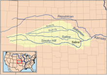
Map of the Smoky Hill drainage basin
Location
CountryUnited States
StateColorado, Kansas
Physical characteristics
Source 
 • locationCheyenne County, Colorado
 • coordinates39°02′06N 102°48′28W / 39.03500°N 102.80778°W / 39.03500; -102.80778
 • elevation4,811 ft (1,466 m)
MouthSmoky Hill River

 • location

Logan County, Kansas

 • coordinates

38°55′13N 101°16′51W / 38.92028°N 101.28083°W / 38.92028; -101.28083[1]

 • elevation

2,940 ft (900 m)
Length195 mi (314 km)
Basin size759 sq mi (1,970 km2)
Basin features
WatershedsNorth Fork Smoky Hill-Smoky Hill-Kansas-Missouri-Mississippi

The North Fork Smoky Hill River is a river in the central Great PlainsofNorth America. A tributary of the Smoky Hill River, it flows from eastern Colorado into western Kansas.[2][3]

Geography

[edit]

The North Fork Smoky Hill River rises in the High Plains region of the Great Plains.[4] Its source lies in extreme northern Cheyenne County, Colorado 29 miles (47 km) west-northwest of Cheyenne Wells, the county seat. From there, the river flows east then east-northeast into Kansas.[2] In south-central Sherman County, it has been dammed to form a small reservoir, Sherman State Fishing Lake.[5][6] A few miles east of the reservoir, the river turns southeast and continues to its confluence with the Smoky Hill River in central Logan County 5 miles (8.0 km) west of Russell Springs.[3]

The river has a total length of 195 miles (314 km) and drains an area of 759 square miles (1,970 km2).[7]

Hydrology

[edit]

The river is intermittent with water flowing only during and after rains.[8]

See also

[edit]

References

[edit]
  1. ^ "North Fork Smoky Hill River". Geographic Names Information System. United States Geological Survey, United States Department of the Interior. Retrieved 2011-02-01.
  • ^ a b "Colorado Travel Map" (PDF). Colorado Department of Transportation. Retrieved 2015-12-08.
  • ^ a b "2003-2004 Official Transportation Map" (PDF). Kansas Department of Transportation. Retrieved 2015-12-08.
  • ^ "Physiographic Provinces of Colorado". Colorado Geological Survey. Retrieved 2015-12-08.
  • ^ "General Highway Map - Sherman County, Kansas". Kansas Department of Transportation. November 2011. Retrieved 2015-12-08.
  • ^ "Sherman State Fishing Lake Fishing Information". Kansas Department of Wildlife, Parks and Tourism. Retrieved 2015-12-08.
  • ^ U.S. Geological Survey. National Hydrography Dataset high-resolution flowline data. The National Map, accessed March 29, 2011
  • ^ "Geohydrology of Sherman County". Kansas Geological Survey. Retrieved 2015-12-09.

  • Retrieved from "https://en.wikipedia.org/w/index.php?title=North_Fork_Smoky_Hill_River&oldid=987054469"

    Categories: 
    Rivers of Kansas
    Rivers of Colorado
    Rivers of Cheyenne County, Colorado
    Tributaries of the Kansas River
    Rivers of Logan County, Kansas
    Hidden categories: 
    Pages using gadget WikiMiniAtlas
    Articles with short description
    Short description is different from Wikidata
    Coordinates on Wikidata


    This page was last edited on 4 November 2020, at 16:45 (UTC).

    Text is available under the Creative Commons Attribution-ShareAlike License 4.0; additional terms may apply. By using this site, you agree to the Terms of Use and Privacy Policy. Wikipedia® is a registered trademark of the Wikimedia Foundation, Inc., a non-profit organization.


    Privacy policy

    About Wikipedia

    Disclaimers

    Contact Wikipedia

    Code of Conduct

    Developers

    Statistics

    Cookie statement

    Mobile view


    Wikimedia Foundation
    Powered by MediaWiki