Jump to content


Main menu


Navigation  


Main page
Contents
Current events
Random article
About Wikipedia
Contact us
Donate


Contribute  


Help
Learn to edit
Community portal
Recent changes
Upload file


Search  


Create account

Log in


Create account
 Log in


Pages for logged out editors learn more  


Contributions
Talk


Contents


(Top)


1 Transport  


2 Shipping  


3 Climate  


4 Demographics  


5 References  


Nsanje


تۆرکجه
Cebuano
Chi-Chewa
Deutsch
فارسی
Français
IsiZulu
Italiano
Kiswahili
Lietuvių
مصرى
Nederlands

Polski
Português
Română
Русский
Svenska
Türkçe


Edit links


Article
Talk


Read
Edit
View history


Tools


Actions  


Read
Edit
View history


General  


What links here
Related changes
Upload file
Special pages
Permanent link
Page information
Cite this page
Get shortened URL
Download QR code
Wikidata item


Print/export  


Download as PDF
Printable version


In other projects  


Wikimedia Commons


Appearance


Coordinates: 16°5500S 35°1600E / 16.91667°S 35.26667°E / -16.91667; 35.26667
 

From Wikipedia, the free encyclopedia


Nsanje
Nsanje is located in Malawi
Nsanje

Location in Malawi

Coordinates: 16°55′00S 35°16′00E / 16.91667°S 35.26667°E / -16.91667; 35.26667
Country Malawi
RegionSouthern Region
DistrictNsanje District
Population
 (2018 Census[1])
 • Total26,844
Time zone+2
ClimateAw

Nsanje (formerly Port Herald) is the main city in Nsanje District within the Southern Region of Malawi.

The intense urbanization in the fertile Shire River valley has formed an extensive urbanized zone that runs from the city of Bangula, further north, passing through the city of Nsanje, in the center, and arriving in the city of Marka, in the south, even crossing the Mozambican border, covering the town of Vila Nova de Fronteira.

Transport[edit]

The city has a railway station on the Sena railway, under concession of Central East African Railways. The railway through Nsanje that connects Blantyre with Beira, Mozambique was severely disrupted by the Mozambique Civil War and remains closed. The main road north connecting the city to the rest of Malawi is being upgraded.

Shipping[edit]

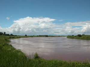
A project is currently underway to dredge part of the Shire River in order to make sea transport to Malawi viable. The Shire merges with the Zambezi River, near Caia, Mozambique, and the Zambezi then flows into the Indian Ocean. As of September, 2010, some of the main concrete work on the jetty was complete and the port was officially declared open in a ceremony attended by President Bingu wa Mutharika of Malawi and President Robert Mugabe of Zimbabwe.[citation needed] However, by August 2016 the port was still incomplete and unused, despite a feasibility study with positive results concluded a few months earlier, and talks were being held on restarting the project.[2]

Climate[edit]

Nsanje lies only about 46 meters above sea level. During the summer months, daytime highs can exceed 120 °F (49 °C).

Demographics[edit]

Year Population[3][1]
1977 6,091
1987 11,009
1998 16,987
2008 20,179
2018 26,844

References[edit]

  1. ^ a b "2018 Population and Housing Census Main Report" (PDF). Malawi National Statistical Office. Retrieved 25 December 2019.
  • ^ Nyasa Times, August 15, 2016
  • ^ World Gazetteer: Malawi: largest cities and towns and statistics of their population
  • 16°55′00S 35°16′00E / 16.91667°S 35.26667°E / -16.91667; 35.26667


    Retrieved from "https://en.wikipedia.org/w/index.php?title=Nsanje&oldid=1195598448"

    Categories: 
    Shire River
    Populated places in Southern Region, Malawi
    Hidden categories: 
    Pages using gadget WikiMiniAtlas
    Articles needing additional references from January 2017
    All articles needing additional references
    Articles with short description
    Short description matches Wikidata
    All articles with unsourced statements
    Articles with unsourced statements from September 2022
    Coordinates on Wikidata
    Commons category link is on Wikidata


    This page was last edited on 14 January 2024, at 14:18 (UTC).

    Text is available under the Creative Commons Attribution-ShareAlike License 4.0; additional terms may apply. By using this site, you agree to the Terms of Use and Privacy Policy. Wikipedia® is a registered trademark of the Wikimedia Foundation, Inc., a non-profit organization.


    Privacy policy

    About Wikipedia

    Disclaimers

    Contact Wikipedia

    Code of Conduct

    Developers

    Statistics

    Cookie statement

    Mobile view


    Wikimedia Foundation
    Powered by MediaWiki