Jump to content


Main menu


Navigation  


Main page
Contents
Current events
Random article
About Wikipedia
Contact us
Donate


Contribute  


Help
Learn to edit
Community portal
Recent changes
Upload file


Search  


Create account

Log in


Create account
 Log in


Pages for logged out editors learn more  


Contributions
Talk


Contents


(Top)


1 References  


2 External links  


Nuʻuanu Slide


Bahasa Indonesia
 

Edit links


Article
Talk


Read
Edit
View history


Tools


Actions  


Read
Edit
View history


General  


What links here
Related changes
Upload file
Special pages
Permanent link
Page information
Cite this page
Get shortened URL
Download QR code
Wikidata item


Print/export  


Download as PDF
Printable version


Appearance


From Wikipedia, the free encyclopedia


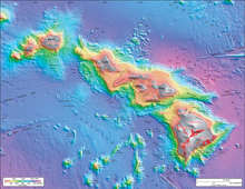
Nuʻuanu Slide is seen near the center top in this bathymetry image of the Hawaiian archipelago,

Nuʻuanu SlideorNuʻuanu Debris Avalanche is the largest of seventeen known submarine landslides around the Hawaiian Islands and at 200 kilometers (124 mi) in length, one of the largest landslides on Earth. It broke from the eastern or windward side of Oʻahu, Hawaiʻi between 1 and 1.5 million years ago and lies in the Pacific Ocean north of Molokaʻi.[1][2]

At the time of collapse, Oʻahu was part of the conglomerate island Maui Nui, elevated above the ocean from lower sea levels, and contained the Koʻolau Volcano. The eastern half of the mountain collapsed nearly in half at the caldera. The remains of the eastern half of the caldera is now Kāneʻohe Bay and the new western side is the Koʻolau Range above the bay, including observation point Nuʻuanu Pali. Though the remaining ridge appears to be a steep and weathered fault scarp, evidence suggests the geographic features are from wind and water rather than the landslide event.[2]

The volcano collapsed nearly in half at the caldera with the eastern half falling into the ocean cataclysmically with enough force to send debris, part of which forms the massive Tuscaloosa Seamount, across the ocean floor and up a ridge.[2] This landslide created a massive tsunami which ravaged the islands and possibly the Western coast of ancient North America. [3]

References

[edit]
  1. ^ "Bathymetry image of the Hawaiian archipelago". United States Geological Survey (USGS).
  • ^ a b c Dunn, Patrick D. (2009). Vanished Islands and Hidden Continents of the Pacific. University of Hawai'i Press. pp. 44–46. ISBN 978-0-8248-3219-3 – via Project MUSE.
  • ^ Satake, Kenji; Smith, John R.; Shinozaki, Ken (2002). "Three-dimensional reconstruction and Tsunami model of the Nuuanu and Wailau giant landslides, Hawaii". Hawaiian Volcanoes: Deep Underwater Perspectives. Geophysical Monograph Series. Vol. 128. pp. 333–346. doi:10.1029/GM128p0333. ISBN 0-87590-987-6 – via ResearchGate.
  • [edit]
    Retrieved from "https://en.wikipedia.org/w/index.php?title=Nuʻuanu_Slide&oldid=1150135669"

    Categories: 
    Geology of Hawaii
    Volcanic landslides
    Megatsunamis
    Volcanic tsunamis
    Prehistoric volcanic events
    Pleistocene geology


    This page was last edited on 16 April 2023, at 14:18 (UTC).

    Text is available under the Creative Commons Attribution-ShareAlike License 4.0; additional terms may apply. By using this site, you agree to the Terms of Use and Privacy Policy. Wikipedia® is a registered trademark of the Wikimedia Foundation, Inc., a non-profit organization.


    Privacy policy

    About Wikipedia

    Disclaimers

    Contact Wikipedia

    Code of Conduct

    Developers

    Statistics

    Cookie statement

    Mobile view


    Wikimedia Foundation
    Powered by MediaWiki