Jump to content


Main menu


Navigation  


Main page
Contents
Current events
Random article
About Wikipedia
Contact us
Donate


Contribute  


Help
Learn to edit
Community portal
Recent changes
Upload file


Search  


Create account

Log in


Create account
 Log in


Pages for logged out editors learn more  


Contributions
Talk


Contents


(Top)


1 History  


2 References  


Nurul Islam Great Mosque


العربية

Bahasa Indonesia
Jawa
مصرى
Bahasa Melayu
Minangkabau
 

Edit links


Article
Talk


Read
Edit
View history


Tools


Actions  


Read
Edit
View history


General  


What links here
Related changes
Upload file
Special pages
Permanent link
Page information
Cite this page
Get shortened URL
Download QR code
Wikidata item


Print/export  


Download as PDF
Printable version


In other projects  


Wikimedia Commons


Appearance


Coordinates: 0°4110S 100°4640E / 0.686050°S 100.77775°E / -0.686050; 100.77775
 

From Wikipedia, the free encyclopedia


Nurul Islam Great Mosque
Sawahlunto Great Mosque
Masjid Agung Nurul Islam
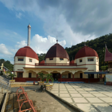
front view
Religion
AffiliationIslam
Location
LocationNorth Kubang Sirakuak, Lembah Segar, Sawahlunto, West Sumatra, Indonesia
Architecture
TypeMosque
Groundbreaking1894
Specifications
Length60 m
Width60 m
Dome(s)5
Minaret(s)1
Minaret height85 m

The Nurul Islam Great Mosque or also known as Sawahlunto Great Mosqueisone of the oldest mosquesinIndonesia located in Kubang Subdistrict of North Sirakuak, District of Lembah Segar, Sawahlunto town, West Sumatra. The location is about 150 meters from the Sawahlunto Railway Museum.[1]

The mosque was built during the Dutch colonial period, and it was originally a steam power plant. The building was built in 1894 and changed its function to a mosque in 1952, while its chimney was later used as a minaret and a 10-meter dome was additionally built.[2] The main building of the mosque measures 60 × 60 meters and has one large dome in the center surrounded by four smaller domes.[3] Underneath the main building was a foxhole that had been used for assembling weapons such as hand grenades and mortars.[4]

Currently in addition to its function as a place of worship for Muslims, this two-story mosque is also used as a place of religious education for the surrounding community.

History[edit]

Smoke coming out of the chimney during the time when it was a power plant.

The growth of infrastructure in Sawahlunto town triggered by coal mining activities experienced a rapid development in the late 19th century. In line with that, to be able to move various electric machines, the government of the Dutch East Indies built a steam powered power plant by utilizing the stream of Batang Lunto River in Kubang Sirakuak in 1894.[5][6] Considering the water level on the edge of the power plant was increasingly decreasing however, the government of the Dutch East Indies built a replacement power plant in Salak, Talawi in 1924 which utilizes the stream of Batang Ombilin River.[7]

No longer functional power plant building in Kubang Sirakuak was then used as a place for protection and assembly of weapons by independence fighters in Sawahlunto during the Indonesian revolution before finally converted into a mosque in 1952, while the chimney as high as more than 75 meters was turned into minarets, and an additional 10 meters tall dome was added.[6]

References[edit]

Footnotes
  • ^ VIVAnews.com 2012.
  • ^ Aroengbinang, Bambang 2012.
  • ^ Liputan6.com 2005.
  • ^ Asoka 2005.
  • ^ a b PadangKini.com 2008.
  • ^ Sumut Pos 2011.
  • Bibliography
    • Asoka, Andi (2005). Sawahlunto Dulu, Kini, dan Esok Menyongsong Kota Wisata Tambang yang Berbudaya. Yogyakarta: Meja Malam Desain Grafis dan Nailil Printika. ISBN 978-979-3723-50-1.
  • "Wisata Tambang di Sawahlunto". VIVAnews.com. 2012-06-14. Retrieved 2012-09-07.
  • "Sawahlunto: Kota Tua Bernuansa Pertambangan". Indonesia Travel. Kementerian Pariwisata dan Ekonomi Kreatif Indonesia. Retrieved 2012-09-07.
  • "Bungker Peninggalan Belanda Ditemukan". Liputan6.com. 2005-06-06. Retrieved 2012-09-07.
  • "Pembangkit Listrik Jadi Masjid". Sumut Pos. 2011-12-04. Retrieved 2012-09-07.
  • "Melihat Bekas Pabrik Senjata Pejuang Sawahlunto". PadangKini.com. 2008-08-14. Retrieved 2012-09-07.
  • Aroengbinang, Bambang (26 July 2012). "Masjid Agung Nurul Islam Sawahlunto". Retrieved 2012-09-07.
  • 0°41′10S 100°46′40E / 0.686050°S 100.77775°E / -0.686050; 100.77775


    Retrieved from "https://en.wikipedia.org/w/index.php?title=Nurul_Islam_Great_Mosque&oldid=1228664039"

    Categories: 
    Cultural Properties of Indonesia in West Sumatra
    Dutch colonial architecture in Indonesia
    Mosques in West Sumatra
    Tourist attractions in West Sumatra
    Hidden categories: 
    Pages using gadget WikiMiniAtlas
    Articles with short description
    Short description is different from Wikidata
    Commons category link is on Wikidata
    Coordinates on Wikidata


    This page was last edited on 12 June 2024, at 13:45 (UTC).

    Text is available under the Creative Commons Attribution-ShareAlike License 4.0; additional terms may apply. By using this site, you agree to the Terms of Use and Privacy Policy. Wikipedia® is a registered trademark of the Wikimedia Foundation, Inc., a non-profit organization.


    Privacy policy

    About Wikipedia

    Disclaimers

    Contact Wikipedia

    Code of Conduct

    Developers

    Statistics

    Cookie statement

    Mobile view


    Wikimedia Foundation
    Powered by MediaWiki