Jump to content


Main menu


Navigation  


Main page
Contents
Current events
Random article
About Wikipedia
Contact us
Donate


Contribute  


Help
Learn to edit
Community portal
Recent changes
Upload file


Search  


Create account

Log in


Create account
 Log in


Pages for logged out editors learn more  


Contributions
Talk


Contents


(Top)


1 References  


2 External links  


Old Man River's City project


Add links


Article
Talk


Read
Edit
View history


Tools


Actions  


Read
Edit
View history


General  


What links here
Related changes
Upload file
Special pages
Permanent link
Page information
Cite this page
Get shortened URL
Download QR code
Wikidata item


Print/export  


Download as PDF
Printable version


Appearance


From Wikipedia, the free encyclopedia


Fuller's model for the city

The Old Man River's City project was an architectural design created by Buckminster Fuller in 1971.[1] Fuller was asked to design the structure by the city of East St. Louis. Old Man River's City would have been a truly massive housing project for the city's 70,000 residents. The total capacity of the building, a circular multi-terraced dome, would be 125,000 occupants. Each family would have approximately 2,500 square feet (230 m2) of living space.[2]
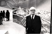
R. Buckminster Fuller stands in front of a depiction of his domed city design at its first public showing at a community meeting in East St. Louis, Illinois.

I originally came to East St. Louis to discuss the design and possible realization of the Old Man River's City, having been asked to do so by East St. Louis community leaders themselves ... It is moon-crater-shaped: the crater's truncated cone top opening is a half-mile in diameter, rim-to-rim, while the truncated mountain itself is a mile in diameter at its base ring. The city has a one-mile (1.6 km)-diameter geodesic, quarter-sphere transparent umbrella mounted high above it to permit full, all-around viewing below the umbrella's bottom perimeter. The top of the dome roof is 1,000 feet (300 m) high. The bottom rim of the umbrella dome is 500 feet (150 m) above the surrounding terrain, while the crater-top esplanade, looks 250 feet (76 m) radially inward from the umbrella's bottom, is at the same 500-foot (150 m) height. From the esplanade the truncated mountain cone slopes downwardly, inward and outward, to ground level 500 feet (150 m) below.

The moon crater's inward and outward, exterior-surface slopes each consist of fifty terraces - the terrace floors are tiered vertically ten feet above or below one another. All the inwardly, downwardly sloping sides of the moon crater's terraced cone are used for communal life; its outward-sloping, tree-planted terraces are entirely for private life dwelling.

— Buckminster Fuller, Critical Path

References

[edit]
  • ^ Baldwin, J. (1996). Bucky Works: Buckminster Fuller's Ideas Today. John Wiley & Sons. pp. 184–185. ISBN 0471129534.
  • [edit]


  • t
  • e

  • Retrieved from "https://en.wikipedia.org/w/index.php?title=Old_Man_River%27s_City_project&oldid=1192585335"

    Categories: 
    Buckminster Fuller
    Planned communities in the United States
    Buildings and structures in St. Clair County, Illinois
    East St. Louis, Illinois
    1971 establishments in Illinois
    Proposed arcologies
    Illinois building and structure stubs
    Hidden categories: 
    Articles needing additional references from June 2007
    All articles needing additional references
    Wikipedia articles with style issues from November 2022
    All articles with style issues
    Articles with multiple maintenance issues
    Illinois articles missing geocoordinate data
    All articles needing coordinates
    Articles missing coordinates without coordinates on Wikidata
    All stub articles


    This page was last edited on 30 December 2023, at 05:20 (UTC).

    Text is available under the Creative Commons Attribution-ShareAlike License 4.0; additional terms may apply. By using this site, you agree to the Terms of Use and Privacy Policy. Wikipedia® is a registered trademark of the Wikimedia Foundation, Inc., a non-profit organization.


    Privacy policy

    About Wikipedia

    Disclaimers

    Contact Wikipedia

    Code of Conduct

    Developers

    Statistics

    Cookie statement

    Mobile view


    Wikimedia Foundation
    Powered by MediaWiki