Jump to content


Main menu


Navigation  


Main page
Contents
Current events
Random article
About Wikipedia
Contact us
Donate


Contribute  


Help
Learn to edit
Community portal
Recent changes
Upload file


Search  


Create account

Log in


Create account
 Log in


Pages for logged out editors learn more  


Contributions
Talk


Contents


(Top)


1 Navigation  


2 Battle of the Boyne Site  


3 References  


Oldbridge


Add links


Article
Talk


Read
Edit
View history


Tools


Actions  


Read
Edit
View history


General  


What links here
Related changes
Upload file
Special pages
Permanent link
Page information
Cite this page
Get shortened URL
Download QR code
Wikidata item


Print/export  


Download as PDF
Printable version


Appearance


Coordinates: 53°4255N 6°2433W / 53.715309°N 6.409204°W / 53.715309; -6.409204
 

From Wikipedia, the free encyclopedia


The River Boyne at Oldbridge

Oldbridge (Irish: An Seandroichead)[1] is a townland near DroghedainCounty Meath, Ireland.[2] The area is home to the Boyne Navigation, the Battle of the Boyne Interpretive Centre and the southern half of the Mary McAleese Boyne Valley Bridge (which carries the M1 motorway).

[edit]

The townland represents the furthest tidal reach on the River Boyne at a point called the "Curly Hole". Curly Hole is also a fishing location.[3] Prior to the 12th century, this was the lowest crossing point of the Boyne. The Abbey of Mellifont owned the lands and fisheries here at dissolution in 1539. It was described then as "Oldebryge. 26 fishermen with 26 boats de Corrio (sc.corachs) paying £13.6.8". The Irish coracle was used for salmon fishing at this location up to at least the first half of the 20th century.[4] One of the last coracles made locally was made in 1928 by Michael O'Brien of Oldbridge, for Adolf Mahr director of the National Museum of Ireland.[5][6]
Battle of the Boyne Site

[edit]
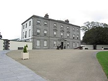
Oldbridge House now houses the Battle of the Boyne Visitor Centre
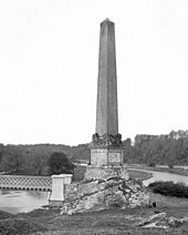
Former Boyne Obelisk (pictured c.1890), which was erected near Oldbridge in 1736 to commemorate the Battle of the Boyne. It was destroyed in 1923.

The site of the Battle of the Boyne extends over an area west of the town of Drogheda. In the County Development Plan for 2000, Meath County Council rezoned the land at the eastern edge of Oldbridge, at the site of the main Williamite crossing, to residential status. A subsequent planning application for a development of over 700 houses was granted by Meath County Council and this was appealed by local historians to An Bord Pleanala (The Planning Board). In March 2008 after a long appeal process, An Bord Pleanala approved permission for this development to proceed.[citation needed]

The Battle of the Boyne Interpretive Centre is approximately 1-mile (1.6 km) to the west of the main crossing point, on Oldbridge Estate.[7][8] This facility was redeveloped in 2008 and is open to tourists.[8]

In early 2007, the newly elected First Minister of Northern Ireland, Ian Paisley, was invited to visit the battle site by the then Taoiseach Bertie Ahern. Following the invitation, Paisley commented that "such a visit would help to demonstrate how far we have come when we can celebrate and learn from the past so the next generation more clearly understands". The visit took place in May 2007 and a tree was planted in the grounds of Oldbridge House to mark the occasion.[9]

References

[edit]
  1. ^ "An Seandroichead / Oldbridge". logainm.ie. Irish Placenames Commission. Retrieved 12 November 2018.
  • ^ "Oldbridge Townland, Co. Meath". townlands.ie. Irish Townlands. Retrieved 12 November 2018.
  • ^ "Salmon and Sea trout fishing - East - Boyne River". fishinginireland.info. Fishing in Ireland. Retrieved 12 November 2018.
  • ^ "The Ancient Art of the Coracle". independent.ie. Independent News & Media. 2 April 2004. Retrieved 12 November 2018.
  • ^ "A lost craft: coracle building on the Boyne". tcd.ie. Trinity College Dublin. 20 October 2016. Retrieved 12 November 2018.
  • ^ "History of Ireland in 100 Objects - Boyne coracle, 1928". irishtimes.com. Irish Times. 24 November 2012. Retrieved 12 November 2018.
  • ^ "Official Battle of the Boyne Interpretive Centre website". OPW. Retrieved 28 December 2014.
  • ^ a b "Battle of the Boyne Visitor Centre". discoverireland.ie. Fáilte Ireland. Retrieved 12 November 2018.
  • ^ "BBC News – Paisley and Ahern visit 1690 site". BBC. 11 May 2007. Retrieved 12 November 2018.
  • 53°42′55N 6°24′33W / 53.715309°N 6.409204°W / 53.715309; -6.409204

  • t
  • e

  • Retrieved from "https://en.wikipedia.org/w/index.php?title=Oldbridge&oldid=1222060508"

    Categories: 
    Geography of County Meath
    Drogheda
    Ireland geography stubs
    Hidden categories: 
    Pages using gadget WikiMiniAtlas
    Articles with short description
    Short description matches Wikidata
    Use dmy dates from November 2019
    Use Hiberno-English from November 2019
    All Wikipedia articles written in Hiberno-English
    Articles containing Irish-language text
    All articles with unsourced statements
    Articles with unsourced statements from February 2017
    Coordinates on Wikidata
    All stub articles


    This page was last edited on 3 May 2024, at 16:58 (UTC).

    Text is available under the Creative Commons Attribution-ShareAlike License 4.0; additional terms may apply. By using this site, you agree to the Terms of Use and Privacy Policy. Wikipedia® is a registered trademark of the Wikimedia Foundation, Inc., a non-profit organization.


    Privacy policy

    About Wikipedia

    Disclaimers

    Contact Wikipedia

    Code of Conduct

    Developers

    Statistics

    Cookie statement

    Mobile view


    Wikimedia Foundation
    Powered by MediaWiki