Jump to content


Main menu


Navigation  


Main page
Contents
Current events
Random article
About Wikipedia
Contact us
Donate


Contribute  


Help
Learn to edit
Community portal
Recent changes
Upload file


Search  


Create account

Log in


Create account
 Log in


Pages for logged out editors learn more  


Contributions
Talk


Contents


(Top)


1 Demographics  


2 See also  


3 References  


Olney-Oak Lane, Philadelphia


Add links


Article
Talk


Read
Edit
View history


Tools


Actions  


Read
Edit
View history


General  


What links here
Related changes
Upload file
Special pages
Permanent link
Page information
Cite this page
Get shortened URL
Download QR code
Wikidata item


Print/export  


Download as PDF
Printable version


Appearance


Coordinates: 40°0251N 75°0602W / 40.04759°N 75.10065°W / 40.04759; -75.10065
 

From Wikipedia, the free encyclopedia


Olney-Oak Lane
Fern Rock Transportation Center
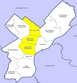
Map of Philadelphia, with Olney-Oak Lane at top of highlighted area (click for larger image)
Country United States of America
State Pennsylvania
County Philadelphia
City Philadelphia
Population
 (2010)
 • Total168,770
ZIP code
  • 19120
  • 19126
  • 19138
  • 19141
  • 19150
  • Olney-Oak Lane, Philadelphia, is a section of Philadelphia that is immediately north of North Philadelphia and south of Cheltenham. It is an area that consists of the now defunct township that was called "Bristol Township, Philadelphia County, Pennsylvania". The section is often excluded as part of North Philadelphia by city government agencies,[1] though locally it is often referred to as "Uptown,"[citation needed] along with the GermantownChestnut Hill area.

    The section includes the neighborhoods of East Oak Lane and West Oak Lane, Feltonville, Fern Rock, Koreatown, Logan, Ogontz, Cedarbrook and Olney.

    Demographics

    [edit]

    As of 2010, the Olney-Oak Lane section of Philadelphia had a population of 168,770, with 76,576 males, 92,195 females and a median age of 33.[2]

    Racial demographics:[3][4]

    See also

    [edit]

    References

    [edit]
    1. ^ "OpenDataPhilly - Planning Analysis Sections". Archived from the original on 2014-10-27. Retrieved 2014-10-27.
  • ^ "Olney - Oak Lane, Philadelphia, PA".
  • ^ "Factfinder at census.gov". Archived from the original on 2020-02-12. Retrieved 2013-10-14.
  • ^ "2010 Census". Medgar Evers College. Archived from the original on 2010-06-11. Retrieved 2010-04-13.
  • 40°02′51N 75°06′02W / 40.04759°N 75.10065°W / 40.04759; -75.10065


    Retrieved from "https://en.wikipedia.org/w/index.php?title=Olney-Oak_Lane,_Philadelphia&oldid=1189231080"

    Categories: 
    Olney-Oak Lane, Philadelphia
    Neighborhoods in Philadelphia
    Hidden categories: 
    Pages using gadget WikiMiniAtlas
    Articles with short description
    Short description is different from Wikidata
    Pages using infobox settlement with no coordinates
    All articles with unsourced statements
    Articles with unsourced statements from February 2017
    Articles containing potentially dated statements from 2010
    All articles containing potentially dated statements
    Coordinates on Wikidata


    This page was last edited on 10 December 2023, at 15:37 (UTC).

    Text is available under the Creative Commons Attribution-ShareAlike License 4.0; additional terms may apply. By using this site, you agree to the Terms of Use and Privacy Policy. Wikipedia® is a registered trademark of the Wikimedia Foundation, Inc., a non-profit organization.


    Privacy policy

    About Wikipedia

    Disclaimers

    Contact Wikipedia

    Code of Conduct

    Developers

    Statistics

    Cookie statement

    Mobile view


    Wikimedia Foundation
    Powered by MediaWiki